|
|
| St. Charles Airport |
| IATA: none – ICAO: none – FAA LID: 3SQ |
| Summary |
| Airport type |
Public |
| Owner |
P.F.A. Associates |
| Serves |
St. Charles, Missouri |
| Elevation AMSL |
442 ft / 135 m |
| Coordinates |
38°50′55.181″N 090°30′00.426″W / 38.84866139°N 90.50011833°W / 38.84866139; -90.50011833 |
| Runways |
| Direction |
Length |
Surface |
| ft |
m |
| 09/27 |
3,451 |
1,052 |
Asphalt |
| 15/33 |
2,310 |
704 |
Turf |
| 18/36 |
2,145 |
654 |
Turf |
| Statistics (2007) |
| Aircraft operations |
40,260 |
| Based aircraft |
77 |
| Source: Federal Aviation Administration |
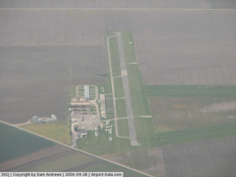
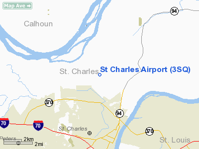
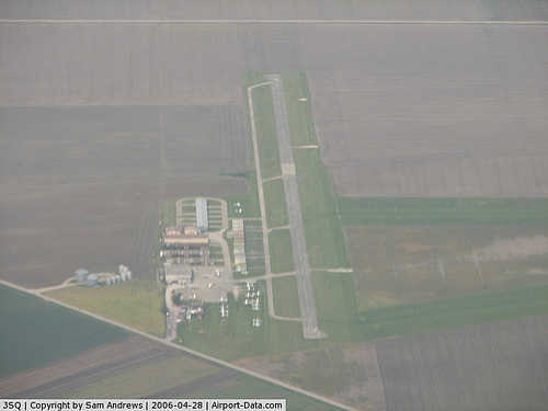
St. Charles Airport Closed June 30, 2010. It was a public use airport in St. Charles County, Missouri, United States. It is privately owned by P.F.A. Associates and is located four nautical miles (7.41 km) north of the central business district of the city of St. Charles. According to the FAA's National Plan of Integrated Airport Systems for 2007-2011, it is categorized as a reliever airport.
Although most U.S. airports use the same three-letter location identifier for the FAA and IATA, St. Charles Airport is assigned 3SQ by the FAA but has no designation from the IATA.
Facilities and aircraft
St. Charles Airport covers an area of 72 acres (29 ha) at an elevation of 442 feet (135 m) above mean sea level. It has one asphalt runway: 09/27 measuring 3,451 by 50 feet (1,052 x 15 m) and two turf runways: 15/33 measuring 2,310 by 103 feet (704 x 31 m) and 18/36 measuring 2,145 by 100 feet (654 x 30 m).
For the 12-month period ending August 27, 2007, the airport had 40,260 aircraft operations, an average of 151 per day: 95% general aviation and 5% air taxi. At that time there were 77 aircraft based at this airport: 88% single-engine, 10% multi-engine, and 1% ultralights.
The above content comes from Wikipedia and is published under free licenses – click here to read more.
|
 |
(Click on the photo to enlarge) |
Location & QuickFacts
| FAA Information Effective: | 2008-09-25 |
| Airport Identifier: | 3SQ |
| Airport Status: | Operational |
| Longitude/Latitude: | 090-30-00.4260W/38-50-55.1810N
-90.500118/38.848661 (Estimated) |
| Elevation: | 442 ft / 134.72 m (Surveyed) |
| Land: | 72 acres |
| From nearest city: | 4 nautical miles N of St Charles, MO |
| Location: | St Charles County, MO |
| Magnetic Variation: | 04E (1975) |
Owner & Manager
| Ownership: | Privately owned |
| Owner: | P.f.a. Associates |
| Address: | 165 N. Meramec, Suite 150
Clayton, MO 63105 |
| Phone number: | 314-727-5600 |
| Manager: | Dennis Bampton |
| Address: | 3001 New Town Blvd.
St. Charles, MO 63301 |
| Phone number: | 636-946-6066 |
Airport Operations and Facilities
| Airport Use: | Open to public |
| Wind indicator: | Yes |
| Segmented Circle: | No |
| Control Tower: | No |
| Lighting Schedule: | DUSK-DAWN
ACTVT VASI RY 09; PAPI RY 27 - CTAF. |
| Beacon Color: | Clear-Green (lighted land airport) |
| Landing fee charge: | No |
| Sectional chart: | St Louis |
| Region: | ACE - Central |
| Traffic Pattern Alt: | 650 ft |
| Boundary ARTCC: | ZKC - Kansas City |
| Tie-in FSS: | STL - Saint Louis |
| FSS on Airport: | No |
| FSS Toll Free: | 1-800-WX-BRIEF |
| NOTAMs Facility: | STL (NOTAM-d service avaliable) |
| Federal Agreements: | N |
Airport Communications
| CTAF: | 123.000 |
| Unicom: | 123.000 |
Airport Services
| Fuel available: | 100LL |
| Airframe Repair: | MAJOR |
| Power Plant Repair: | MAJOR |
| Bottled Oxygen: | NONE |
| Bulk Oxygen: | NONE |
Runway Information
Runway 09/27
| Dimension: | 3451 x 50 ft / 1051.9 x 15.2 m |
| Surface: | ASPH, Poor Condition
ROUGH RY SURFACE. TRANSVERSE ASPHALT RIDGES OVER MAJORITY OF RY.
ROLLING & UNEVEN.
ROLLING ROUGH AND UNEVEN.
VARIOUS AREAS ARE ROLLING AND ROUGH. |
| Weight Limit: | Single wheel: 8000 lbs. |
| Edge Lights: | Non-standard lighting system
NSTD LIRL; 4 THLD LGTS RY 09; ALL THLD LGT LENS NSTD COLOR; THLD LGTS AND RY EDGE LGTS PLACED 45-50 FT FM PAVEMENT EDGE. RY EDGE LGTS WHITE LAST 1700 FT OF RY 09. |
| |
Runway 09 |
Runway 27 |
| Longitude: | 090-30-27.3680W | 090-29-43.7530W |
| Latitude: | 38-50-49.0760N | 38-50-48.5900N |
| Elevation: | 442.00 ft | 442.00 ft |
| Alignment: | 91 | 127 |
| Traffic Pattern: | Left | Right |
| Markings: | Nonstandard, Fair Condition
MARKINGS FADED. | Nonstandard, Fair Condition
MARKINGS FADED. |
| Crossing Height: | 40.00 ft | 39.00 ft |
| VASI: | 4-box on left side | 4-light PAPI on right side |
| Visual Glide Angle: | 3.00° | 3.00° |
| Obstruction: | 26 ft brdg, 896.0 ft from runway, 26:1 slope to clear
+1-10' CROPS, 0-200 FT FM RY END, 0B. | 20 ft pline, 325.0 ft from runway, 250 ft left of centerline, 6:1 slope to clear |
|
Runway 15/33
| Dimension: | 2310 x 103 ft / 704.1 x 31.4 m |
| Surface: | TURF, Fair Condition
ROUGH RY SURFACE. TRANSVERSE ASPHALT RIDGES OVER MAJORITY OF RY.
ROLLING & UNEVEN.
ROLLING ROUGH AND UNEVEN.
VARIOUS AREAS ARE ROLLING AND ROUGH. |
| |
Runway 15 |
Runway 33 |
| Traffic Pattern: | Left | Left |
| Displaced threshold: | 400.00 ft | 0.00 ft |
| Obstruction: | 16 ft road, 40.0 ft from runway, 2:1 slope to clear
25:1 TO DSPLCD THLD | 20 ft pline, 650.0 ft from runway, 32:1 slope to clear |
|
Runway 18/36
| Dimension: | 2145 x 100 ft / 653.8 x 30.5 m |
| Surface: | TURF, Fair Condition
ROUGH RY SURFACE. TRANSVERSE ASPHALT RIDGES OVER MAJORITY OF RY.
ROLLING & UNEVEN.
ROLLING ROUGH AND UNEVEN.
VARIOUS AREAS ARE ROLLING AND ROUGH. |
| |
Runway 18 |
Runway 36 |
| Traffic Pattern: | Left | Left |
| Displaced threshold: | 400.00 ft | 200.00 ft |
| Obstruction: | 16 ft road, 40.0 ft from runway, 2:1 slope to clear
27:1 TO DSPLCD THLD | 20 ft bldg, 450.0 ft from runway, 22:1 slope to clear
32:1 TO DSPLCD THLD. |
|
Radio Navigation Aids
| ID |
Type |
Name |
Ch |
Freq |
Var |
Dist |
| LM | NDB | Oblio | | 338.00 | 00E | 3.1 nm |
| CVM | NDB | Civic Memorial | | 263.00 | 02E | 20.9 nm |
| FES | NDB | Festus | | 269.00 | 01E | 39.6 nm |
| BL | NDB | Belleville | | 362.00 | 02E | 41.8 nm |
| LTD | NDB | Litchfield | | 371.00 | 01E | 43.0 nm |
| UUV | NDB | Sullivan | | 356.00 | 02E | 48.3 nm |
| PPQ | NDB | Pittsfield | | 344.00 | 02E | 49.4 nm |
| SKE | TACAN | Scott | 059X | | 02E | 35.5 nm |
| CSX | VOR/DME | Cardinal | 111Y | 116.45 | 00E | 8.7 nm |
| STL | VORTAC | St Louis | 121X | 117.40 | 01E | 1.1 nm |
| FTZ | VORTAC | Foristell | 045X | 110.80 | 05E | 23.9 nm |
| TOY | VORTAC | Troy | 107X | 116.00 | 04E | 28.0 nm |
| STL | VOT | St Louis Lambert | | 111.00 | | 8.8 nm |
| SUS | VOT | Spirit Of St Louis | | 112.20 | | 13.3 nm |
Remarks
- PARTIAL PARALLEL TWY FOR RY 09/27 LOCATED 70-75 FT FM RY.
- MODERATE STUDENT TRAINING.
- NTSD RY SAFETY AREA CLEARING AND TERRAIN GRADES BYD THE ENDS OF RYS 09,27,15,& 18; CROPS AND DITCH.
- CROPS LOCATED 60 FT FM RY THLDS AND 120 FT FM CNTRLN FIRST 1,800 FT OF RY 09 ARE WITHIN RY OBJECT FREE AREA & PRIMARY AND TRANSITIONAL SURFACES.
- EXISTED PRIOR TO 1959.
Images and information placed above are from
http://www.airport-data.com/airport/3SQ/
We thank them for the data!
| General Info
|
| Country |
United States
|
| State |
MISSOURI
|
| FAA ID |
3SQ
|
| Latitude |
38-50-55.181N
|
| Longitude |
090-30-00.426W
|
| Elevation |
442 feet
|
| Near City |
ST CHARLES
|
We don't guarantee the information is fresh and accurate. The data may
be wrong or outdated.
For more up-to-date information please refer to other sources.
|
|