 |
|
|
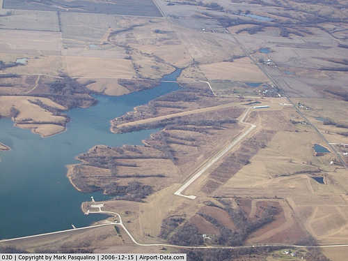 |
(Click on the photo to enlarge) |
Location & QuickFacts
| FAA Information Effective: | 2008-09-25 |
| Airport Identifier: | 03D |
| Airport Status: | Operational |
| Longitude/Latitude: | 092-13-37.0000W/40-26-50.0000N
-92.226944/40.447222 (Estimated) |
| Elevation: | 813 ft / 247.80 m (Estimated) |
| Land: | 80 acres |
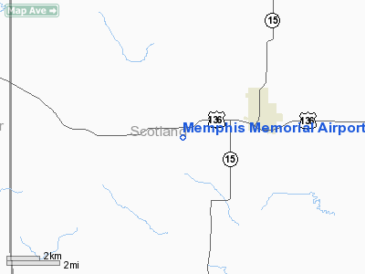
| From nearest city: | 3 nautical miles SW of Memphis, MO |
| Location: | Scotland County, MO |
| Magnetic Variation: | 03E (1985) |
Owner & Manager
| Ownership: | Publicly owned |
| Owner: | City Of Memphis |
| Address: | 135 S Main
Memphis, MO 63555 |
| Phone number: | 660-465-7285 |
| Manager: | H Middleton
CHAIRMAN ARPT BOARD. |
| Address: | 114 West Monroe
Memphis, MO 63555 |
| Phone number: | 660-465-8595 |
Airport Operations and Facilities
| Airport Use: | Open to public |
| Wind indicator: | Yes |
| Segmented Circle: | Yes |
| Control Tower: | No |
| Lighting Schedule: | DUSK-DAWN |
| Beacon Color: | Clear-Green (lighted land airport) |
| Landing fee charge: | No |
| Sectional chart: | Chicago |
| Region: | ACE - Central |
| Boundary ARTCC: | ZKC - Kansas City |
| Tie-in FSS: | COU - Columbia |
| FSS on Airport: | No |
| FSS Toll Free: | 1-800-WX-BRIEF |
| NOTAMs Facility: | COU (NOTAM-d service avaliable) |
| Federal Agreements: | N |
Airport Communications
Airport Services
| Fuel available: | 100LL
FOR FUEL CALL (660) 465-2611. |
| Bottled Oxygen: | NONE |
| Bulk Oxygen: | NONE |
Runway Information
Runway 12/30
| Dimension: | 3300 x 60 ft / 1005.8 x 18.3 m |
| Surface: | CONC, Fair Condition
ISOLATED AREAS WITH LONGITUDINAL CRACKING. |
| Weight Limit: | Single wheel: 12500 lbs. |
| Edge Lights: | Low |
| |
Runway 12 |
Runway 30 |
| Longitude: | 092-13-55.0800W | 092-13-18.9000W |
| Latitude: | 40-26-58.7000N | 40-26-41.3800N |
| Traffic Pattern: | Left | Left |
| Markings: | Basic, Poor Condition
RWY 12 MARKINGS FADED. | Basic, Fair Condition |
| Obstruction: | 21 ft pole, 1096.0 ft from runway, 113 ft right of centerline, 42:1 slope to clear | 30 ft trees, 1100.0 ft from runway, 100 ft right of centerline, 30:1 slope to clear |
|
Radio Navigation Aids
| ID |
Type |
Name |
Ch |
Freq |
Var |
Dist |
| BEX | NDB | Bloomfield | | 269.00 | 02E | 20.2 nm |
| TVK | NDB | Centerville | | 290.00 | 04E | 33.9 nm |
| FFL | NDB | Fairfield | | 332.00 | 03E | 35.6 nm |
| EOK | NDB | Keokuk | | 366.00 | 02E | 36.3 nm |
| MPZ | NDB | Mount Pleasant | | 212.00 | 02E | 44.2 nm |
| OOA | NDB | Oskaloosa | | 414.00 | 03E | 48.3 nm |
| OTM | VOR/DME | Ottumwa | 053X | 111.60 | 06E | 35.3 nm |
| MCM | VOR/DME | Macon | 076X | 112.90 | 06E | 49.1 nm |
| IRK | VORTAC | Kirksville | 093X | 114.60 | 06E | 25.1 nm |
Remarks
- RADIO CONTROLLED MODEL PLANES ON & INVOF ARPT.
- PROVIDED APCH TO EACH RWY IS MAINTAINED FOR A MIN 20:1 GLIDE SLOPE AND THE TRANSITIONAL SURFACE BE MAINTAINED FOR A 7:1 SLOPE.
Images and information placed above are from
http://www.airport-data.com/airport/03D/
We thank them for the data!
| General Info
|
| Country |
United States
|
| State |
MISSOURI
|
| FAA ID |
03D
|
| Latitude |
40-26-50.132N
|
| Longitude |
092-13-37.058W
|
| Elevation |
813 feet
|
| Near City |
MEMPHIS
|
We don't guarantee the information is fresh and accurate. The data may
be wrong or outdated.
For more up-to-date information please refer to other sources.
|
|


