|
|
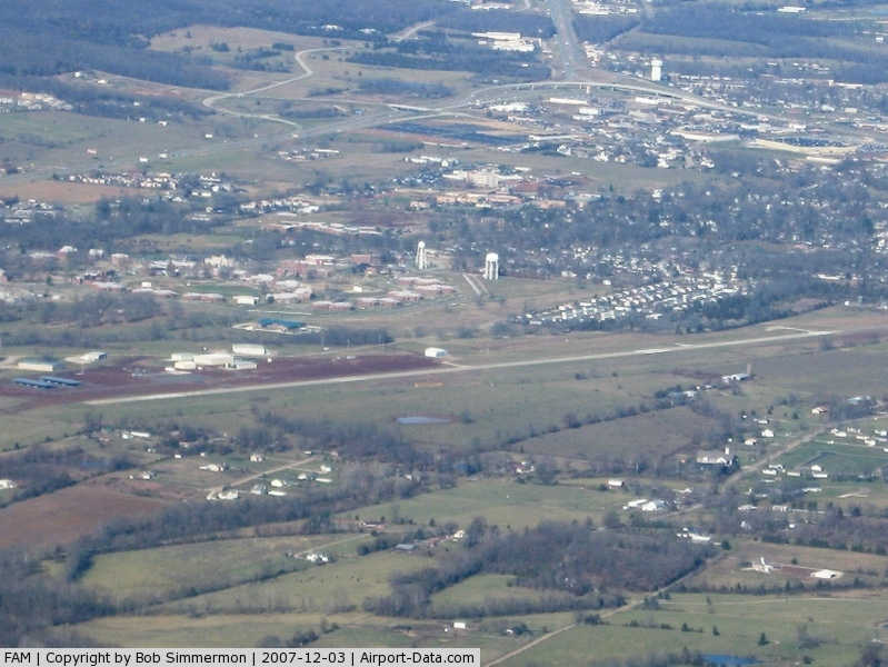
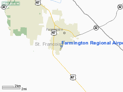
Farmington Regional Airport |
|
 |
(Click on the photo to enlarge) |
Location & QuickFacts
| FAA Information Effective: | 2008-09-25 |
| Airport Identifier: | FAM |
| Airport Status: | Operational |
| Longitude/Latitude: | 090-25-42.9500W/37-45-39.8850N
-90.428597/37.761079 (Estimated) |
| Elevation: | 947 ft / 288.65 m (Surveyed) |
| Land: | 188 acres |
| From nearest city: | 1 nautical miles S of Farmington, MO |
| Location: | St Francois County, MO |
| Magnetic Variation: | 02E (1990) |
Owner & Manager
| Ownership: | Publicly owned |
| Owner: | City Of Farmington |
| Address: | 110 W. Columbia St., Long Memorial Bldg.
Farmington, MO 63640 |
| Phone number: | 314-756-4413 |
| Manager: | Larry Mccormick |
| Address: | 1436 Perrine Rd
Farmington, MO 63640 |
| Phone number: | 573-756-4502 |
Airport Operations and Facilities
| Airport Use: | Open to public |
| Wind indicator: | Yes |
| Segmented Circle: | Yes |
| Control Tower: | No |
| Lighting Schedule: | DUSK-DAWN
ACTVT MIRL RY 02/20 & REIL RWY 02 - CTAF. PAPI RWY 02 ON 24 HRS. |
| Beacon Color: | Clear-Green (lighted land airport) |
| Landing fee charge: | No |
| Sectional chart: | St Louis |
| Region: | ACE - Central |
| Boundary ARTCC: | ZKC - Kansas City |
| Tie-in FSS: | STL - Saint Louis |
| FSS on Airport: | No |
| FSS Toll Free: | 1-800-WX-BRIEF |
| NOTAMs Facility: | FAM (NOTAM-d service avaliable) |
| Federal Agreements: | NGY |
Airport Communications
| CTAF: | 122.800 |
| Unicom: | 122.800 |
Airport Services
| Fuel available: | 100LLA |
| Airframe Repair: | MAJOR |
| Power Plant Repair: | MAJOR |
| Bottled Oxygen: | NONE |
| Bulk Oxygen: | NONE |
Runway Information
Runway 02/20
| Dimension: | 4221 x 75 ft / 1286.6 x 22.9 m
100 FT X 75 FT FULL STRENGTH CONC SAFETY AREA SOUTHWEST END; 590 FT BY 60 FT ASPH SAFETY AREA NORTHEAST END, NOT FULL STRENGTH. |
| Surface: | CONC, Good Condition |
| Weight Limit: | Single wheel: 30000 lbs.
FOR RY ONLY; CONTACT AMGR FOR TWY STRENGHT. |
| Edge Lights: | Medium |
| |
Runway 02 |
Runway 20 |
| Longitude: | 090-25-53.2000W | 090-25-31.9800W |
| Latitude: | 37-45-21.4100N | 37-45-59.6300N |
| Elevation: | 910.00 ft | 945.00 ft |
| Alignment: | 24 | 127 |
| Traffic Pattern: | Right | Left |
| Markings: | Non-precision instrument, Fair Condition | Basic, Poor Condition
RWY 20 MARKINGS FADED. |
| Crossing Height: | 40.00 ft | 0.00 ft |
| Displaced threshold: | 223.00 ft
RY 02 DSPLCD THLD 1 FT HIGHER THAN END OF RY. | 0.00 ft |
| VASI: | 4-light PAPI on left side | |
| Visual Glide Angle: | 3.00° | 0.00° |
| Runway End Identifier: | Yes | |
| Obstruction: | 29 ft trees, 906.0 ft from runway, 348 ft right of centerline, 24:1 slope to clear
RWY 02 RY 02-APCH SLOPE 32:1 TO DSPLCD THLD. | 79 ft tree, 1449.0 ft from runway, 56 ft left of centerline, 15:1 slope to clear |
|
Radio Navigation Aids
| ID |
Type |
Name |
Ch |
Freq |
Var |
Dist |
| PRI | NDB | Perrine | | 367.00 | 02E | 0.2 nm |
| FES | NDB | Festus | | 269.00 | 01E | 26.2 nm |
| SAR | NDB | Sparta | | 239.00 | 01E | 41.5 nm |
| UUV | NDB | Sullivan | | 356.00 | 02E | 45.0 nm |
| FAM | VORTAC | Farmington | 104X | 115.70 | 01E | 10.6 nm |
Remarks
- HEL ACTIVITY ON & INVOF AIRFIELD.
- (OVERRUN LEN, RWY 02) 560 FT UNUSBL.
- PROVIDED A CLEAR APCH TO EACH RY FOR A MINIM 20:1 GLIDE SLOPE AND A CLEAR TRANSITIONAL SFC FOR A 7:1 SLOPE.
Images and information placed above are from
http://www.airport-data.com/airport/FAM/
We thank them for the data!
| General Info
|
| Country |
United States
|
| State |
MISSOURI
|
| FAA ID |
FAM
|
| Latitude |
37-45-39.885N
|
| Longitude |
090-25-42.950W
|
| Elevation |
947 feet
|
| Near City |
FARMINGTON
|
We don't guarantee the information is fresh and accurate. The data may
be wrong or outdated.
For more up-to-date information please refer to other sources.
|
|