 |
|
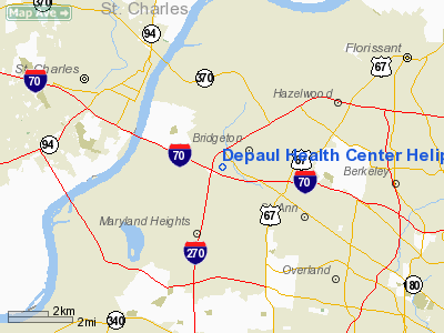
Depaul Health Center Heliport |
Location & QuickFacts
| FAA Information Effective: | 2008-09-25 |
| Airport Identifier: | MO92 |
| Airport Status: | Operational |
| Longitude/Latitude: | 090-26-00.4230W/38-45-00.1840N
-90.433451/38.750051 (Estimated) |
| Elevation: | 543 ft / 165.51 m (Estimated) |
| Land: | 0 acres |
| From nearest city: | 0 nautical miles N of Bridgeton, MO |
| Location: | St Louis County, MO |
| Magnetic Variation: | 02E (1985) |
Owner & Manager
| Ownership: | Privately owned |
| Owner: | Depaul Health Center |
| Address: | 12303 Depaul Drive
St. Louis, MO 63044 |
| Phone number: | 314-344-6360 |
| Manager: | Robert Henkel |
| Address: | 12303 Depaul Drive
St. Louis, MO 63044 |
| Phone number: | 573-344-7205 |
Airport Operations and Facilities
| Airport Use: | Private
MEDICAL. |
| Wind indicator: | Yes |
| Segmented Circle: | No |
| Control Tower: | No |
| Lighting Schedule: | PHONE REQ
FOR HELIPAD LGTS CALL 314-344-7055. |
| Landing fee charge: | No |
| Sectional chart: | St Louis |
| Region: | ACE - Central |
| Boundary ARTCC: | ZKC - Kansas City |
| Tie-in FSS: | STL - Saint Louis |
| FSS on Airport: | No |
| FSS Toll Free: | 1-800-WX-BRIEF |
Runway Information
Helipad H1
| Dimension: | 60 x 60 ft / 18.3 x 18.3 m
90' X 90' ASPH LANDING/TAKEOFF AREA. |
| Surface: | ASPH, |
| |
Runway H1 |
Runway |
| Traffic Pattern: | Left | Left |
| Obstruction: | 50 ft pole | |
|
Radio Navigation Aids
| ID |
Type |
Name |
Ch |
Freq |
Var |
Dist |
| LM | NDB | Oblio | | 338.00 | 00E | 3.6 nm |
| CVM | NDB | Civic Memorial | | 263.00 | 02E | 19.6 nm |
| FES | NDB | Festus | | 269.00 | 01E | 33.4 nm |
| BL | NDB | Belleville | | 362.00 | 02E | 36.1 nm |
| LTD | NDB | Litchfield | | 371.00 | 01E | 43.3 nm |
| UUV | NDB | Sullivan | | 356.00 | 02E | 46.2 nm |
| SKE | TACAN | Scott | 059X | | 02E | 30.0 nm |
| CSX | VOR/DME | Cardinal | 111Y | 116.45 | 00E | 3.4 nm |
| STL | VORTAC | St Louis | 121X | 117.40 | 01E | 7.0 nm |
| TOY | VORTAC | Troy | 107X | 116.00 | 04E | 24.1 nm |
| FTZ | VORTAC | Foristell | 045X | 110.80 | 05E | 25.4 nm |
| STL | VOT | St Louis Lambert | | 111.00 | | 3.3 nm |
| SUS | VOT | Spirit Of St Louis | | 112.20 | | 11.5 nm |
Remarks
- PROVDD THE APCH/DEP PATHS ARE MAINTD FOR A 8:1 SLOPE & TRSNL SFC MAINTD FOR A 2:1 SLOPE. LGT POLE LCTD 110' E OF PAD BE REMOVED & RELCTD SW OF SE INGRESS/EGRESS RTE. WND CONE RELCTD SW OF NNW RTE & INGRESS/EGRESS RTES BE RESTRD TO NNW & SE ONLY.
Images and information placed above are from
http://www.airport-data.com/airport/MO92/
We thank them for the data!
| General Info
|
| Country |
United States
|
| State |
MISSOURI
|
| FAA ID |
MO92
|
| Latitude |
38-45-00.184N
|
| Longitude |
090-26-00.423W
|
| Elevation |
543 feet
|
| Near City |
BRIDGETON
|
We don't guarantee the information is fresh and accurate. The data may
be wrong or outdated.
For more up-to-date information please refer to other sources.
|
|


