 |
|
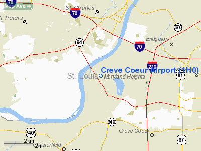
| Creve Coeur Airport |
| IATA: none – ICAO: none – FAA LID: 1H0 |
| Summary |
| Airport type |
Private |
| Owner |
Creve Coeur Airport Impr. Corp. |
| Location |
Maryland Heights, Missouri |
| Elevation AMSL |
463 ft / 141.1 m |
| Coordinates |
38°43′36″N 90°30′30″W / 38.72667°N 90.50833°W / 38.72667; -90.50833 |
| Runways |
| Direction |
Length |
Surface |
| ft |
m |
| 16/34 |
4,500 |
1,372 |
Concrete |
| 7/25 |
3,120 |
951 |
Turf |
| Statistics (2007) |
| Aircraft operations |
33,640 |
| Based aircraft |
316 |
| Area (Acres) |
400 |
| Source: Federal Aviation Administration |
Creve Coeur Airport (FAA LID: 1H0) is a small general aviation airport located in Maryland Heights, Missouri. The airport is also home to the Historic Aircraft Restoration Museum.
The above content comes from Wikipedia and is published under free licenses – click here to read more.
Location & QuickFacts
| FAA Information Effective: | 2008-09-25 |
| Airport Identifier: | 1H0 |
| Airport Status: | Operational |
| Longitude/Latitude: | 090-30-29.7000W/38-43-36.2000N
-90.508250/38.726722 (Estimated) |
| Elevation: | 463 ft / 141.12 m (Surveyed) |
| Land: | 400 acres |
| From nearest city: | 4 nautical miles NW of St Louis, MO |
| Location: | St Louis County, MO |
| Magnetic Variation: | 00E (2000) |
Owner & Manager
| Ownership: | Privately owned |
| Owner: | Creve Coeur Arpt Impr Corp |
| Address: | 3127 Creve Coeur Mill Rd
St Louis, MO 63146 |
| Phone number: | 314-878-6400 |
| Manager: | Bob Cameron |
| Address: | 3127 Creve Coeur Mill Rd
St Louis, MO 63146 |
| Phone number: | 314-878-6400 |
Airport Operations and Facilities
| Airport Use: | Open to public |
| Wind indicator: | Yes |
| Segmented Circle: | Yes |
| Control Tower: | No |
| Lighting Schedule: | DUSK-DAWN
MIRL RY 16/34 PRESET ON LOW INTST; TO INCR INTST & ACTVT REIL RYS 16 & 34 - CTAF. |
| Beacon Color: | Clear-Green (lighted land airport) |
| Landing fee charge: | No |
| Sectional chart: | St Louis |
| Region: | ACE - Central |
| Traffic Pattern Alt: | 650 ft |
| Boundary ARTCC: | ZKC - Kansas City |
| Tie-in FSS: | STL - Saint Louis |
| FSS on Airport: | No |
| FSS Toll Free: | 1-800-WX-BRIEF |
| NOTAMs Facility: | STL (NOTAM-d service avaliable) |
| Federal Agreements: | N |
Airport Communications
| CTAF: | 122.800 |
| Unicom: | 122.800 |
Airport Services
| Fuel available: | 100LLA |
| Airframe Repair: | MAJOR |
| Power Plant Repair: | MINOR |
| Bottled Oxygen: | NONE |
| Bulk Oxygen: | NONE |
Runway Information
Runway 07/25
| Dimension: | 3120 x 220 ft / 951.0 x 67.1 m |
| Surface: | TURF, Fair Condition |
| |
Runway 07 |
Runway 25 |
| Longitude: | 090-30-35.4320W | 090-30-00.4310W |
| Latitude: | 38-43-35.1870N | 38-43-47.1860N |
| Traffic Pattern: | Left | Right |
| Obstruction: | 68 ft trees, 2600.0 ft from runway, 38:1 slope to clear | 12 ft crops, 4.0 ft from runway, 1:1 slope to clear |
|
Runway 16/34
| Dimension: | 4500 x 75 ft / 1371.6 x 22.9 m |
| Surface: | CONC, Good Condition |
| Weight Limit: | Single wheel: 3000 lbs.
RY 16/34 RESTRICTED TO ACFT 30,000 LBS MAX GROSS WEIGHT OR LESS, SINGLE WHEEL. |
| Edge Lights: | Medium |
| |
Runway 16 |
Runway 34 |
| Longitude: | 090-30-48.3043W | 090-30-27.4385W |
| Latitude: | 38-43-53.8214N | 38-43-12.4529N |
| Elevation: | 451.00 ft | 462.00 ft |
| Alignment: | 127 | 127 |
| Traffic Pattern: | Right | Left |
| Markings: | Non-precision instrument, Good Condition | Non-precision instrument, Good Condition |
| Crossing Height: | 40.00 ft | 30.00 ft |
| VASI: | 4-light PAPI on left side | 4-light PAPI on left side |
| Visual Glide Angle: | 3.00° | 3.00° |
| Runway End Identifier: | Yes | Yes |
| Obstruction: | 62 ft trees, 1364.0 ft from runway, 391 ft right of centerline, 18:1 slope to clear | 18 ft pole, 670.0 ft from runway, 237 ft right of centerline, 26:1 slope to clear |
|
Radio Navigation Aids
| ID |
Type |
Name |
Ch |
Freq |
Var |
Dist |
| LM | NDB | Oblio | | 338.00 | 00E | 4.7 nm |
| CVM | NDB | Civic Memorial | | 263.00 | 02E | 23.4 nm |
| FES | NDB | Festus | | 269.00 | 01E | 32.4 nm |
| BL | NDB | Belleville | | 362.00 | 02E | 38.7 nm |
| UUV | NDB | Sullivan | | 356.00 | 02E | 42.7 nm |
| LTD | NDB | Litchfield | | 371.00 | 01E | 47.0 nm |
| SKE | TACAN | Scott | 059X | | 02E | 32.7 nm |
| CSX | VOR/DME | Cardinal | 111Y | 116.45 | 00E | 7.1 nm |
| STL | VORTAC | St Louis | 121X | 117.40 | 01E | 8.1 nm |
| FTZ | VORTAC | Foristell | 045X | 110.80 | 05E | 21.8 nm |
| TOY | VORTAC | Troy | 107X | 116.00 | 04E | 27.7 nm |
| STL | VOT | St Louis Lambert | | 111.00 | | 7.0 nm |
| SUS | VOT | Spirit Of St Louis | | 112.20 | | 7.8 nm |
Remarks
- ULTRALIGHTS NOT ALLOWED.
- RYS 07/25 & 16/34 CLSD TO TGLS.
- CALL AMGR FOR INFO ABOUT TWY & APRON STRENGTH.
- BE ALERT TO INCREASED ANTIQUE ACFT OPS ON AND INVOF ARPT ON WEEKENDS.
- HELICOPTER OPS ON & INVOF ARPT. HOVER TAXI TRNG OPS ARE CNCTD PARLLEL TO RY 07/25.
Images and information placed above are from
http://www.airport-data.com/airport/1H0/
We thank them for the data!
| General Info
|
| Country |
United States
|
| State |
MISSOURI
|
| FAA ID |
1H0
|
| Latitude |
38-43-39.072N
|
| Longitude |
090-30-29.895W
|
| Elevation |
451 feet
|
| Near City |
ST LOUIS
|
We don't guarantee the information is fresh and accurate. The data may
be wrong or outdated.
For more up-to-date information please refer to other sources.
|
|


