|
|
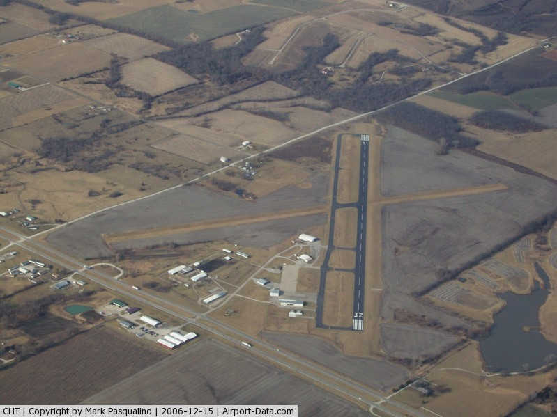
Chillicothe Municipal Airport |
|
 |
(Click on the photo to enlarge) |
Location & QuickFacts
| FAA Information Effective: | 2008-09-25 |
| Airport Identifier: | CHT |
| Airport Status: | Operational |
| Longitude/Latitude: | 093-29-44.4500W/39-46-55.7500N
-93.495681/39.782153 (Estimated) |
| Elevation: | 783 ft / 238.66 m (Surveyed) |
| Land: | 272 acres |
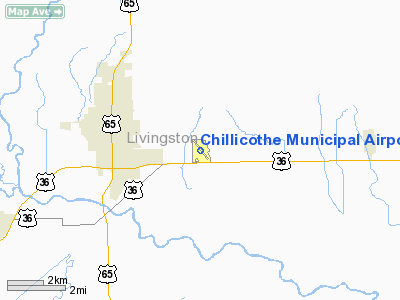
| From nearest city: | 3 nautical miles E of Chillicothe, MO |
| Location: | Livingston County, MO |
| Magnetic Variation: | 03E (1995) |
Owner & Manager
| Ownership: | Publicly owned |
| Owner: | City Of Chillicothe |
| Address: | 715 Washington
Chillicothe, MO 64601 |
| Phone number: | 660-646-1877 |
| Manager: | Bill Kieffer |
| Address: | 13844 Liv 253
Chillicothe, MO 64601 |
| Phone number: | 660-646-5270 |
Airport Operations and Facilities
| Airport Use: | Open to public |
| Wind indicator: | Yes |
| Segmented Circle: | Yes |
| Control Tower: | No |
| Lighting Schedule: | DUSK-DAWN
ACTVT PAPI RY 32 - CTAF. |
| Beacon Color: | Clear-Green (lighted land airport) |
| Landing fee charge: | No |
| Sectional chart: | Kansas City |
| Region: | ACE - Central |
| Boundary ARTCC: | ZKC - Kansas City |
| Tie-in FSS: | COU - Columbia |
| FSS on Airport: | No |
| FSS Toll Free: | 1-800-WX-BRIEF |
| NOTAMs Facility: | COU (NOTAM-d service avaliable) |
| Federal Agreements: | NGY |
Airport Communications
| CTAF: | 122.800 |
| Unicom: | 122.800 |
Airport Services
| Fuel available: | 100LL |
| Bottled Oxygen: | NONE |
| Bulk Oxygen: | NONE |
Runway Information
Runway 02/20
| Dimension: | 3614 x 110 ft / 1101.5 x 33.5 m
WIDTH VARIANCE 74-75 FT. |
| Surface: | TURF, Fair Condition
ROLLING & UNEVEN. |
| |
Runway 02 |
Runway 20 |
| Longitude: | 093-29-57.7670W | 093-29-38.7670W |
| Latitude: | 39-46-39.5650N | 39-47-10.0650N |
| Elevation: | 761.00 ft | 774.00 ft |
| Traffic Pattern: | Left | Left |
| Displaced threshold: | 200.00 ft | 400.00 ft |
| Obstruction: | 35 ft pole, 717.0 ft from runway, 12 ft left of centerline, 20:1 slope to clear
RWY 02 26:1 TO DSPLCD THLD. | 20 ft trees, 406.0 ft from runway, 109 ft right of centerline, 20:1 slope to clear
RWY 20 40:1 TO DSPLCD THLD. |
|
Runway 14/32
| Dimension: | 3900 x 74 ft / 1188.7 x 22.6 m
WIDTH VARIANCE 74-75 FT. |
| Surface: | ASPH, Good Condition
ROLLING & UNEVEN. |
| Weight Limit: | Single wheel: 15000 lbs. |
| Edge Lights: | Medium |
| |
Runway 14 |
Runway 32 |
| Longitude: | 093-29-59.3790W | 093-29-29.5240W |
| Latitude: | 39-47-11.2010N | 39-46-40.3050N |
| Elevation: | 783.00 ft | 763.00 ft |
| Alignment: | 127 | 127 |
| Traffic Pattern: | Left | Left |
| Markings: | Non-precision instrument, Good Condition | Non-precision instrument, Good Condition |
| Crossing Height: | 0.00 ft | 44.00 ft |
| VASI: | | 4-light PAPI on right side |
| Visual Glide Angle: | 0.00° | 3.50° |
| Obstruction: | 17 ft trees, 646.0 ft from runway, 150 ft left of centerline, 26:1 slope to clear | 12 ft road, 505.0 ft from runway, 295 ft left of centerline, 26:1 slope to clear
RWY 32 +1-8 FT TREE, 112 FT FM RWY END 150 FT R; +1-8 FT TREE, 50 FT FM RWY END, 156 FT L. |
|
Radio Navigation Aids
| ID |
Type |
Name |
Ch |
Freq |
Var |
Dist |
| CHT | NDB | Chillicothe | | 375.00 | 03E | 0.3 nm |
| BZK | NDB | Brookfield | | 383.00 | 03E | 17.9 nm |
| TRX | NDB | Trenton | | 400.00 | 03E | 18.5 nm |
| EZZ | NDB | Cameron | | 394.00 | 03E | 36.0 nm |
| GPH | NDB | Mosby | | 284.00 | 03E | 45.8 nm |
| PUR | NDB | Marshall | | 371.00 | 03E | 46.6 nm |
| BQS | VOR/DME | Braymer | 049X | 111.20 | 03E | 19.8 nm |
| MCM | VOR/DME | Macon | 076X | 112.90 | 06E | 47.5 nm |
| IRK | VORTAC | Kirksville | 093X | 114.60 | 06E | 46.7 nm |
Remarks
- ULTRALIGHT ACFT ON & INVOF ARPT.
- WILDLIFE & GEESE ON & INVOF ARPT.
- NTSD RWY SAFETY AREA BYND BOTH ENDS OF RWY 02/20; INCORRECT TERRAIN GRADES AND CROPS.
Images and information placed above are from
http://www.airport-data.com/airport/CHT/
We thank them for the data!
| General Info
|
| Country |
United States
|
| State |
MISSOURI
|
| FAA ID |
CHT
|
| Latitude |
39-46-55.750N
|
| Longitude |
093-29-44.450W
|
| Elevation |
783 feet
|
| Near City |
CHILLICOTHE
|
We don't guarantee the information is fresh and accurate. The data may
be wrong or outdated.
For more up-to-date information please refer to other sources.
|
|