 |
|
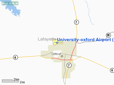
University-oxford Airport |
Location & QuickFacts
| FAA Information Effective: | 2008-09-25 |
| Airport Identifier: | UOX |
| Airport Status: | Operational |
| Longitude/Latitude: | 089-32-12.5000W/34-23-03.6000N
-89.536806/34.384333 (Estimated) |
| Elevation: | 452 ft / 137.77 m (Surveyed) |
| Land: | 297 acres |
| From nearest city: | 2 nautical miles NW of Oxford, MS |
| Location: | Lafayette County, MS |
| Magnetic Variation: | 01E (1990) |
Owner & Manager
| Ownership: | Publicly owned |
| Owner: | University Of Mississippi |
| Address: | P.o. Box 8750
University, MS 38677 |
| Phone number: | 662-915-5435 |
| Manager: | Mac Mcmanus |
| Address: | University/oxford Airport, 1 Airport Road
Oxford, MS 38655 |
| Phone number: | 662-234-2036 |
Airport Operations and Facilities
| Airport Use: | Open to public |
| Wind indicator: | Yes |
| Segmented Circle: | Yes |
| Control Tower: | No |
| Lighting Schedule: | DUSK-DAWN
MIRL RY 09/27 OPERATES DUSK-2200. AFTER 2200, ACTVT MIRL 09/27 - CTAF. |
| Beacon Color: | Clear-Green (lighted land airport) |
| Landing fee charge: | No |
| Sectional chart: | Memphis |
| Region: | ASO - Southern |
| Boundary ARTCC: | ZME - Memphis |
| Tie-in FSS: | GWO - Greenwood |
| FSS on Airport: | No |
| FSS Toll Free: | 1-800-WX-BRIEF |
| NOTAMs Facility: | GWO (NOTAM-d service avaliable) |
| Certification type/date: | IV A U 09/198
CLSD TO ACR OPNS WITH MORE THAN 30 PSGR SEATS EXCP PPR CALL AMGR 662-234-2036. |
| Federal Agreements: | NGY |
Airport Communications
| CTAF: | 123.000 |
| Unicom: | 123.000 |
Airport Services
| Fuel available: | A |
| Airframe Repair: | MINOR |
| Power Plant Repair: | NONE |
| Bottled Oxygen: | NONE |
| Bulk Oxygen: | NONE |
Runway Information
Runway 09/27
| Dimension: | 5600 x 100 ft / 1706.9 x 30.5 m |
| Surface: | ASPH, Good Condition |
| Weight Limit: | Single wheel: 38000 lbs.
Dual wheel: 55000 lbs.
Dual tandem wheel: 90000 lbs. |
| Edge Lights: | Medium |
| |
Runway 09 |
Runway 27 |
| Longitude: | 089-32-45.8634W | 089-31-39.0594W |
| Latitude: | 34-23-04.0009N | 34-23-03.1945N |
| Elevation: | 413.00 ft | 452.00 ft |
| Alignment: | 91 | 127 |
| ILS Type: | LOCALIZER
| |
| Traffic Pattern: | Left | Left |
| Markings: | Non-precision instrument, Good Condition | Non-precision instrument, Good Condition |
| Crossing Height: | 35.00 ft | 0.00 ft |
| VASI: | 4-box on right side
VASI OTS INDEFLY. | |
| Visual Glide Angle: | 3.00° | 0.00° |
| Runway End Identifier: | | Yes |
| Obstruction: | , 50:1 slope to clear | 40 ft tree, 800.0 ft from runway, 75 ft right of centerline, 15:1 slope to clear |
|
Radio Navigation Aids
| ID |
Type |
Name |
Ch |
Freq |
Var |
Dist |
| SBQ | NDB | Scobey | | 245.00 | 01E | 34.1 nm |
| OLV | NDB | Olive Branch | | 275.00 | 01E | 37.9 nm |
| ME | NDB | Elvis | | 287.00 | 01E | 48.5 nm |
| CKM | NDB | Clarksdale | | 341.00 | 02E | 48.9 nm |
| FYE | NDB | Somerville | | 255.00 | 00E | 49.9 nm |
| OTB | VOR/DME | Tupelo | 035X | 109.80 | 04E | 38.0 nm |
| HLI | VORTAC | Holly Springs | 071X | 112.40 | 03E | 23.3 nm |
| MEM | VORTAC | Memphis | 122X | 117.50 | 01E | 43.9 nm |
| MEM | VOT | Memphis Metropolitn | | 111.00 | | 45.6 nm |
Remarks
Images and information placed above are from
http://www.airport-data.com/airport/UOX/
We thank them for the data!
| General Info
|
| Country |
United States
|
| State |
MISSISSIPPI
|
| FAA ID |
UOX
|
| Latitude |
34-23-03.535N
|
| Longitude |
089-32-07.115W
|
| Elevation |
452 feet
|
| Near City |
OXFORD
|
We don't guarantee the information is fresh and accurate. The data may
be wrong or outdated.
For more up-to-date information please refer to other sources.
|
|


