 |
|
| Tupelo Regional Airport |
| IATA: TUP – ICAO: KTUP |
| Summary |
| Airport type |
Public |
| Operator |
Tupelo Airport Authority |
| Location |
Tupelo, Mississippi |
| Elevation AMSL |
346 ft / 105.5 m |
| Coordinates |
34°16′05.19″N 88°46′11.62″W / 34.2681083°N 88.7698944°W / 34.2681083; -88.7698944Coordinates: 34°16′05.19″N 88°46′11.62″W / 34.2681083°N 88.7698944°W / 34.2681083; -88.7698944 |
| Website |
[1] |
| Runways |
| Direction |
Length |
Surface |
| ft |
m |
| 18/36 |
6,500 |
1,981 |
Asphalt |
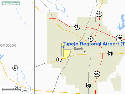
Tupelo Regional Airport (IATA: TUP, ICAO: KTUP) is a public airport located three miles (5 km) west of the city of Tupelo in Lee County, Mississippi, USA. The airport has a single runway. It is mostly used for general aviation, but is also served by one commercial airline.
Airlines
| Airlines |
Destinations |
| Delta Connection operated by Mesaba Airlines |
Atlanta, Memphis |
The above content comes from Wikipedia and is published under free licenses – click here to read more.
Location & QuickFacts
| FAA Information Effective: | 2008-09-25 |
| Airport Identifier: | TUP |
| Airport Status: | Operational |
| Longitude/Latitude: | 088-46-11.6220W/34-16-05.1900N
-88.769895/34.268108 (Estimated) |
| Elevation: | 346 ft / 105.46 m (Surveyed) |
| Land: | 1061 acres |
| From nearest city: | 3 nautical miles W of Tupelo, MS |
| Location: | Lee County, MS |
| Magnetic Variation: | 01E (1985) |
Owner & Manager
| Ownership: | Publicly owned |
| Owner: | Tupelo Airport Authority |
| Address: | 2704 W. Jackson,
Tupelo, MS 38801 |
| Phone number: | 662-823-2375
EXT 8. |
| Manager: | Terry L. Anderson |
| Address: | 2704 W. Jackson, Suite A
Tupelo, MS 38801 |
| Phone number: | 662-823-2375 |
Airport Operations and Facilities
| Airport Use: | Open to public |
| Wind indicator: | Yes |
| Segmented Circle: | Yes |
| Control Tower: | Yes |
| Lighting Schedule: | DUSK-DAWN
ACTVT HIRL RY 18/36, MALSR RY 36 & REIL RY 18 - CTAF. ON 118.775 |
| Beacon Color: | Clear-Green (lighted land airport) |
| Landing fee charge: | No |
| Sectional chart: | Memphis |
| Region: | ASO - Southern |
| Boundary ARTCC: | ZME - Memphis |
| Tie-in FSS: | GWO - Greenwood |
| FSS on Airport: | No |
| FSS Toll Free: | 1-800-WX-BRIEF |
| NOTAMs Facility: | TUP (NOTAM-d service avaliable) |
| Certification type/date: | I A S 05/1973
PPR FOR UNSKED ACR OPNS WITH MORE THAN 30 PSGR SEATS CALL AMGR 662-841-6570 EXT 8. |
| Federal Agreements: | NGY |
Airport Communications
Airport Services
| Fuel available: | 100 A1+ |
| Airframe Repair: | MAJOR |
| Power Plant Repair: | MAJOR |
| Bottled Oxygen: | NONE |
| Bulk Oxygen: | NONE |
Runway Information
Runway 18/36
| Dimension: | 6500 x 100 ft / 1981.2 x 30.5 m |
| Surface: | ASPH, Good Condition |
| Surface Treatment: | Saw-cut or plastic Grooved |
| Weight Limit: | Single wheel: 45000 lbs.
Dual wheel: 60000 lbs.
Dual tandem wheel: 90000 lbs. |
| Edge Lights: | High |
| |
Runway 18 |
Runway 36 |
| Longitude: | 088-46-11.7140W | 088-46-11.5280W |
| Latitude: | 34-16-37.3390N | 34-15-33.0580N |
| Elevation: | 342.00 ft | 346.00 ft |
| Alignment: | 127 | 127 |
| ILS Type: | | ILS/DME
|
| Traffic Pattern: | Left | Left |
| Markings: | Non-precision instrument, Good Condition | Precision instrument, Good Condition |
| Crossing Height: | 34.00 ft | 0.00 ft |
| VASI: | 4-box on left side
ACFT WITH COCKPIT HEIGHTS GREATER THAN 13 FT WILL RECEIVE INACCURATE VISUAL REFERENCE. | |
| Visual Glide Angle: | 3.00° | 0.00° |
| Approach lights: | | MALSR |
| Runway End Identifier: | Yes
REIL RY 18 OTS INDEFLY. | |
|
Radio Navigation Aids
| ID |
Type |
Name |
Ch |
Freq |
Var |
Dist |
| OTB | VOR/DME | Tupelo | 035X | 109.80 | 04E | 3.0 nm |
| HAB | VORTAC | Hamilton | 041X | 110.40 | 02E | 37.9 nm |
| CBM | VORTAC | Caledonia | 099X | 115.20 | 00E | 41.1 nm |
| HLI | VORTAC | Holly Springs | 071X | 112.40 | 03E | 47.0 nm |
| IGB | VORTAC | Bigbee | 109X | 116.20 | 04E | 48.7 nm |
Remarks
- HEL OPNS ALL HRS 700' AGL E OF RY 18/36; CTC CTAF FOR ADZY.
- ACR RAMP RSTRD TO ACR OPNS EXCP WITH PPR CALL AMGR 662-841-6570 EXT 8.
- HELICOPTER PARKING & REFUELING CTC FBO ON 128.85 OR 129.9.
- SERVICE: ACFT WITH COCKPIT HGT GREATER THAN 13' WILL RCV INACCURATE VASI VISUAL REF RWY 18.
- FUEL: A+ (SOUTHERNAIRE CARRIERS INC., 1200-0200Z++ WKD; 1400-0200Z++ WKEND; C662-842-6918 OT C662-841-0658 OR C662-678-4914.) (NC-100, 100LL, A1+)
- RSTD: COPTER PRK AND REFUL RSTD TO E END OF CLSD RWY, CTC FBO ON 128.85 OR 129.9. ACFT RAMP RSTD TO ACFT OPR EXC WITH PPR CALL ARPT MGR C662-841-6570, EXTN 8.
- CAUTION: COPTER OPR ALL HR 700 FT AGL E OF RY 18-36 CTC CTAF.
- ARNG: SUPPORT FAC OPR 1300-2200Z++ MON-FRI EXC HOL. LTD PRK AVBL. NO TRAN FUEL. DSN 293-3400 C662-891-4400.
- EXISTED PRIOR TO 1959.
Images and information placed above are from
http://www.airport-data.com/airport/TUP/
We thank them for the data!
| General Info
|
| Country |
United States
|
| State |
MISSISSIPPI
|
| FAA ID |
TUP
|
| Latitude |
34-16-05.190N
|
| Longitude |
088-46-11.622W
|
| Elevation |
346 feet
|
| Near City |
TUPELO
|
We don't guarantee the information is fresh and accurate. The data may
be wrong or outdated.
For more up-to-date information please refer to other sources.
|
|


