 |
|
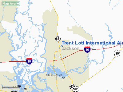
Trent Lott International Airport |
| Trent Lott International Airport |
| IATA: PGL – ICAO: KPQL – FAA LID: PQL |
| Summary |
| Airport type |
Public |
| Owner |
Jackson County |
| Serves |
Pascagoula, Mississippi |
| Elevation AMSL |
17 ft / 5 m |
| Coordinates |
30°27′46″N 088°31′45″W / 30.46278°N 88.52917°W / 30.46278; -88.52917 |
| Website |
www.co.jackson.ms.us/... |
| Runways |
| Direction |
Length |
Surface |
| ft |
m |
| 17/35 |
6,500 |
1,981 |
Asphalt |
| Statistics (2007) |
| Aircraft operations |
50,205 |
| Based aircraft |
53 |
| Source: Federal Aviation Administration |
Trent Lott International Airport (IATA: PGL, ICAO: KPQL, FAA LID: PQL) is a county-owned public-use airport located six miles (10 km) north of the central business district of Pascagoula, a city in Jackson County, Mississippi, United States. The airport is named for Trent Lott, the United States Senator from Mississippi.
Although most U.S. airports use the same three-letter location identifier for the FAA and IATA, Trent Lott International Airport is assigned PQL by the FAA and PGL by the IATA. PGL was formerly assigned to Jackson County Airport in Pascagoula which closed sometime between 1982 and 1989.
DayJet provided an on-demand jet air taxi service from this airport to Jacksonville, Lakeland, Tallahassee, Pensacola, Gainesville, Boca Raton, Opa-Locka/Miami Dade County, Naples, Sarasota/Bradenton, Savannah, Macon, and Montgomery. This service ended in September 2008.
Facilities and aircraft
Trent Lott International Airport covers an area of 906 acres (367 ha) and has one runway designated 17/35 with an asphalt pavement measuring 6,500 x 100 ft (1,981 x 30 m).
For the 12-month period ending May 31, 2007, the airport had 50,205 aircraft operations, an average of 137 per day: 87% general aviation, 10% air taxi and 4% military. At that time there were 53 aircraft based at this airport: 66% single-engine, 15% multi-engine, 13% jet and 6% helicopter.
The airport offers flight lessons as well as parachuting/skydiving lessons.
The above content comes from Wikipedia and is published under free licenses – click here to read more.
Location & QuickFacts
| FAA Information Effective: | 2008-09-25 |
| Airport Identifier: | PQL |
| Airport Status: | Operational |
| Longitude/Latitude: | 088-31-45.2200W/30-27-46.0120N
-88.529228/30.462781 (Estimated) |
| Elevation: | 17 ft / 5.18 m (Surveyed) |
| Land: | 906 acres |
| From nearest city: | 6 nautical miles N of Pascagoula, MS |
| Location: | Jackson County, MS |
| Magnetic Variation: | 01E (1995) |
Owner & Manager
| Ownership: | Publicly owned |
| Owner: | Jackson County
DR. KENNETH SMITH - CHAIRMAN, AIRPORT BOARD. |
| Address: | 8301 Saracennia
Moss Point, MS 39563-9478 |
| Phone number: | 228-769-3089 |
| Manager: | Carol Snapp |
| Address: | 8301 Saracennia Rd
Moss Point, MS 39563-9478 |
| Phone number: | 228-475-1371 |
Airport Operations and Facilities
| Airport Use: | Open to public |
| Wind indicator: | Yes |
| Segmented Circle: | Yes |
| Control Tower: | Yes |
| Lighting Schedule: | DUSK-DAWN
ACTVT MIRL RY 17/35, PAPI 35 & MALSR RY 17 - CTAF. |
| Beacon Color: | Clear-Green (lighted land airport) |
| Sectional chart: | New Orleans |
| Region: | ASO - Southern |
| Boundary ARTCC: | ZHU - Houston |
| Tie-in FSS: | GWO - Greenwood |
| FSS Toll Free: | 1-800-WX-BRIEF |
| NOTAMs Facility: | PQL (NOTAM-d service avaliable) |
| Federal Agreements: | NGY |
Airport Communications
| CTAF: | 118.575 |
| Unicom: | 122.800 |
Airport Services
| Fuel available: | 100LLA |
| Airframe Repair: | MAJOR |
| Power Plant Repair: | MAJOR |
Runway Information
Runway 17/35
| Dimension: | 6500 x 100 ft / 1981.2 x 30.5 m |
| Surface: | ASPH, Good Condition |
| Surface Treatment: | Saw-cut or plastic Grooved |
| Weight Limit: | Dual wheel: 60000 lbs. |
| Edge Lights: | Medium |
| |
Runway 17 |
Runway 35 |
| Longitude: | 088-31-54.1730W | 088-31-36.2680W |
| Latitude: | 30-28-17.2300N | 30-27-14.7950N |
| Elevation: | 16.00 ft | 17.00 ft |
| Alignment: | 127 | 127 |
| ILS Type: | ILS
| |
| Traffic Pattern: | Left | Left |
| Markings: | Precision instrument, Good Condition | Non-precision instrument, Good Condition |
| Crossing Height: | 0.00 ft | 40.00 ft |
| VASI: | | 4-light PAPI on left side |
| Visual Glide Angle: | 0.00° | 3.03° |
| Approach lights: | MALSR | |
|
Radio Navigation Aids
| ID |
Type |
Name |
Ch |
Freq |
Var |
Dist |
| MO | NDB | Wisle | | 248.00 | 02E | 21.4 nm |
| ESU | NDB | Summerdale | | 204.00 | 01E | 41.7 nm |
| HS | NDB | Hanco | | 221.00 | 01E | 48.0 nm |
| AYI | NDB | Hanco | | 221.00 | 03E | 48.0 nm |
| BIX | TACAN | Keesler | 055X | | 01E | 21.0 nm |
| GPT | VOR/DME | Gulfport | 27X | 109.00 | 02E | 28.5 nm |
| SJI | VORTAC | Semmes | 100X | 115.30 | 05E | 18.1 nm |
| BFM | VORTAC | Brookley | 075X | 112.80 | 04E | 26.1 nm |
| GCV | VORTAC | Greene County | 104X | 115.70 | 05E | 38.2 nm |
Images and information placed above are from
http://www.airport-data.com/airport/PQL/
We thank them for the data!
| General Info
|
| Country |
United States
|
| State |
MISSISSIPPI
|
| FAA ID |
PQL
|
| Latitude |
30-27-46.012N
|
| Longitude |
088-31-45.220W
|
| Elevation |
17 feet
|
| Near City |
PASCAGOULA
|
We don't guarantee the information is fresh and accurate. The data may
be wrong or outdated.
For more up-to-date information please refer to other sources.
|
|


