 |
|
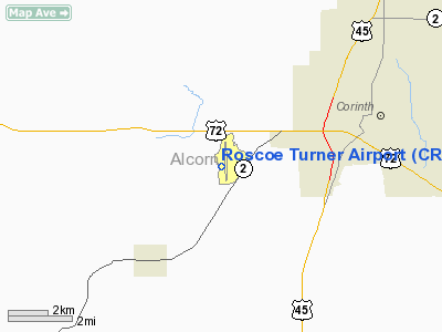
Location & QuickFacts
| FAA Information Effective: | 2008-09-25 |
| Airport Identifier: | CRX |
| Airport Status: | Operational |
| Longitude/Latitude: | 088-36-12.5410W/34-54-53.8840N
-88.603484/34.914968 (Estimated) |
| Elevation: | 425 ft / 129.54 m (Surveyed) |
| Land: | 542 acres |
| From nearest city: | 4 nautical miles SW of Corinth, MS |
| Location: | Alcorn County, MS |
| Magnetic Variation: | 02W (2010) |
Owner & Manager
| Ownership: | Publicly owned |
| Owner: | Roscoe Turner |
| Address: | 56 County Road 613
Corinth, MS 38834 |
| Phone number: | 662-286-6644 |
| Manager: | Mr. James A. Witt |
| Address: | 56 County Road 613
Corinth, MS 38834 |
| Phone number: | 662-287-3223 |
Airport Operations and Facilities
| Airport Use: | Open to public |
| Wind indicator: | Yes |
| Segmented Circle: | Yes |
| Control Tower: | No |
| Lighting Schedule: | DUSK-DAWN
ACTVT MIRL RY 18/36, MALSR RY 18 - CTAF. |
| Beacon Color: | Clear-Green (lighted land airport) |
| Landing fee charge: | No |
| Sectional chart: | Memphis |
| Region: | ASO - Southern |
| Boundary ARTCC: | ZME - Memphis |
| Tie-in FSS: | GWO - Greenwood |
| FSS on Airport: | No |
| FSS Toll Free: | 1-800-WX-BRIEF |
| NOTAMs Facility: | GWO (NOTAM-d service avaliable) |
| Federal Agreements: | NGY |
Airport Communications
| CTAF: | 122.800 |
| Unicom: | 122.800 |
Airport Services
| Fuel available: | 100LLA |
| Airframe Repair: | MAJOR |
| Power Plant Repair: | MAJOR |
| Bottled Oxygen: | NONE |
| Bulk Oxygen: | NONE |
Runway Information
Runway 18/36
| Dimension: | 6500 x 100 ft / 1981.2 x 30.5 m |
| Surface: | ASPH, Good Condition |
| Weight Limit: | Single wheel: 30000 lbs. |
| Edge Lights: | Medium |
| |
Runway 18 |
Runway 36 |
| Longitude: | 088-36-16.9270W | 088-36-08.1560W |
| Latitude: | 34-55-25.8250N | 34-54-21.9430N |
| Elevation: | 403.00 ft | 425.00 ft |
| Alignment: | 127 | 127 |
| ILS Type: | ILS | |
| Traffic Pattern: | Left | Left |
| Markings: | Precision instrument, Good Condition | Precision instrument, Good Condition |
| Crossing Height: | 45.00 ft | 54.00 ft |
| VASI: | 2-light PAPI on left side | 2-light PAPI on left side |
| Visual Glide Angle: | 3.00° | 3.00° |
| Approach lights: | MALSR | |
|
Radio Navigation Aids
| ID |
Type |
Name |
Ch |
Freq |
Var |
Dist |
| SZY | NDB | Sibley | | 386.00 | 01E | 19.8 nm |
| BAV | NDB | Hardeman | | 404.00 | 01E | 28.1 nm |
| HHY | NDB | Pinhook | | 346.00 | 01W | 28.3 nm |
| FYE | NDB | Somerville | | 255.00 | 00E | 42.6 nm |
| OTB | VOR/DME | Tupelo | 035X | 109.80 | 04E | 42.6 nm |
| JKS | VOR/DME | Jacks Creek | 031X | 109.40 | 02E | 42.8 nm |
| MKL | VOR/DME | Mc Kellar | 057X | 112.00 | 02E | 44.0 nm |
| HLI | VORTAC | Holly Springs | 071X | 112.40 | 03E | 44.9 nm |
Remarks
Images and information placed above are from
http://www.airport-data.com/airport/CRX/
We thank them for the data!
| General Info
|
| Country |
United States
|
| State |
MISSISSIPPI
|
| FAA ID |
CRX
|
| Latitude |
34-54-53.884N
|
| Longitude |
088-36-12.541W
|
| Elevation |
425 feet
|
| Near City |
CORINTH
|
We don't guarantee the information is fresh and accurate. The data may
be wrong or outdated.
For more up-to-date information please refer to other sources.
|
|


