 |
|
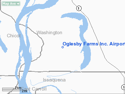
Oglesby Farms Inc. Airport |
Location & QuickFacts
| FAA Information Effective: | 2008-09-25 |
| Airport Identifier: | MS86 |
| Airport Status: | Operational |
| Longitude/Latitude: | 091-05-00.3840W/33-03-00.4440N
-91.083440/33.050123 (Estimated) |
| Elevation: | 110 ft / 33.53 m (Estimated) |
| Land: | 0 acres |
| From nearest city: | 5 nautical miles NW of Glen Allan, MS |
| Location: | Washington County, MS |
| Magnetic Variation: | 03E (1985) |
Owner & Manager
| Ownership: | Privately owned |
| Owner: | John W. Oglesby |
| Address: | Po Box 205
Chatham, MS 38731 |
| Phone number: | 601-827-5246 |
| Manager: | John W. Oglesby |
| Address: | Po Box 205
Chatham, MS 38731 |
| Phone number: | 601-827-5246 |
Airport Operations and Facilities
| Airport Use: | Private |
| Wind indicator: | Yes |
| Segmented Circle: | No |
| Control Tower: | No |
| Lighting Schedule: | PHONE REQ
FOR RWY LGTS CALL 601-827-5246. |
| Landing fee charge: | No |
| Sectional chart: | Memphis |
| Region: | ASO - Southern |
| Boundary ARTCC: | ZME - Memphis |
| Tie-in FSS: | GWO - Greenwood |
| FSS on Airport: | No |
| FSS Toll Free: | 1-800-WX-BRIEF |
Runway Information
Runway 14/32
| Dimension: | 2400 x 60 ft / 731.5 x 18.3 m |
| Surface: | TURF, |
| |
Runway 14 |
Runway 32 |
| Traffic Pattern: | Left | Right |
| Obstruction: | 35 ft pline, 1000.0 ft from runway | |
|
Radio Navigation Aids
| ID |
Type |
Name |
Ch |
Freq |
Var |
Dist |
| BLE | NDB | Lake Providence | | 278.00 | 03E | 14.2 nm |
| MTQ | NDB | Metcalf | | 359.00 | 03E | 23.1 nm |
| IDL | NDB | Indianola | | 284.00 | 03E | 33.0 nm |
| BQP | NDB | Bastrop | | 329.00 | 03E | 44.1 nm |
| RNV | NDB | Renova | | 272.00 | 04E | 48.3 nm |
| TV | NDB | Savry | | 344.00 | 02E | 48.5 nm |
| VKS | NDB | Vicksburg | | 382.00 | 03E | 49.8 nm |
| GLH | VOR/DME | Greenville | 039X | 110.20 | 04E | 28.9 nm |
| MON | VOR/DME | Monticello | 053X | 111.60 | 04E | 44.2 nm |
| SQS | VORTAC | Sidon | 094X | 114.70 | 03E | 47.5 nm |
Remarks
- (E111-1) WEST & NORTH OF LAKE JACKSON; AGRMT IS MAINTD WITH OWNER OF LAKE WASHINGTON ARPT THAT TFC PAT AT LAKE WASHINGTON ARPT WILL BE FLOWN NORTH OF THE LAKE.
- VFR USE ONLY; TFC PAT ARE ESTABD & FLOWN NE SIDE OF RWY 14/32 NORTH & EAST OF LAKE JACKSON; & SOUTH OF LAKE WASHINGTON; AGRMT IS MAINTD WITH W R ROGERS ARPT THAT ROGERS' TFC PAT WILL BE FLOWN SOUTH;.
Images and information placed above are from
http://www.airport-data.com/airport/MS86/
We thank them for the data!
| General Info
|
| Country |
United States
|
| State |
MISSISSIPPI
|
| FAA ID |
MS86
|
| Latitude |
33-03-00.444N
|
| Longitude |
091-05-00.384W
|
| Elevation |
110 feet
|
| Near City |
GLEN ALLAN
|
We don't guarantee the information is fresh and accurate. The data may
be wrong or outdated.
For more up-to-date information please refer to other sources.
|
|


