 |
|
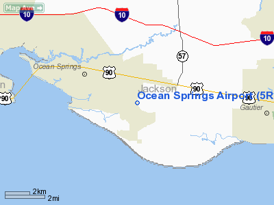
Location & QuickFacts
| FAA Information Effective: | 2008-09-25 |
| Airport Identifier: | 5R2 |
| Airport Status: | Operational |
| Longitude/Latitude: | 088-45-12.4000W/30-23-22.0000N
-88.753444/30.389444 (Estimated) |
| Elevation: | 20 ft / 6.10 m (Surveyed) |
| Land: | 25 acres |
| From nearest city: | 3 nautical miles E of Ocean Springs, MS |
| Location: | Jackson County, MS |
| Magnetic Variation: | 02E (1985) |
Owner & Manager
| Ownership: | Privately owned |
| Owner: | Romac, Inc. |
| Address: | 8600 Blueberry Road
Ocean Springs, MS 39564 |
| Phone number: | 228-872-1962 |
| Manager: | Bill Mcwhirter |
| Address: | 8600 Blueberry Road
Ocean Springs, MS 39564 |
| Phone number: | 228-872-1962
FBO PHONE 228-872-1962. |
Airport Operations and Facilities
| Airport Use: | Open to public |
| Wind indicator: | Yes |
| Segmented Circle: | No |
| Control Tower: | No |
| Lighting Schedule: | RDO-CTL
ACTVT ROTG BCN AND LGTD WINDSOCK - CTAF. |
| Beacon Color: | Clear-Green (lighted land airport)
OTS INDEFLY. |
| Landing fee charge: | No |
| Sectional chart: | New Orleans |
| Region: | ASO - Southern |
| Boundary ARTCC: | ZHU - Houston |
| Tie-in FSS: | GWO - Greenwood |
| FSS on Airport: | No |
| FSS Toll Free: | 1-800-WX-BRIEF |
| NOTAMs Facility: | GWO (NOTAM-d service avaliable) |
Airport Communications
| CTAF: | 122.700 |
| Unicom: | 122.700 |
Airport Services
| Fuel available: | 100LL |
| Airframe Repair: | MINOR |
| Power Plant Repair: | MAJOR |
| Bottled Oxygen: | NONE |
| Bulk Oxygen: | NONE |
Runway Information
Runway 18/36
| Dimension: | 3500 x 50 ft / 1066.8 x 15.2 m |
| Surface: | ASPH, Good Condition |
| Weight Limit: | Single wheel: 10000 lbs. |
| Edge Lights: | Medium |
| |
Runway 18 |
Runway 36 |
| Longitude: | 088-45-12.8600W | 088-45-12.0600W |
| Latitude: | 30-23-40.1500N | 30-23-05.5200N |
| Elevation: | 20.00 ft | 20.00 ft |
| Alignment: | 127 | 127 |
| Traffic Pattern: | Left | Left |
| Markings: | Basic, Good Condition | Basic, Good Condition |
| Runway End Identifier: | Yes | Yes |
| Obstruction: | 44 ft tree, 480.0 ft from runway, 120 ft left of centerline, 6:1 slope to clear | , 20:1 slope to clear
4 FT FENCE 15 FT FM THLD ON EXTDD RY CNTRLN, AND 20 FT TREE 100 FT OUT AND 60 FT LEFT. |
|
Radio Navigation Aids
| ID |
Type |
Name |
Ch |
Freq |
Var |
Dist |
| MO | NDB | Wisle | | 248.00 | 02E | 32.3 nm |
| HS | NDB | Hanco | | 221.00 | 01E | 36.6 nm |
| AYI | NDB | Hanco | | 221.00 | 03E | 36.6 nm |
| MJD | NDB | Picayune | | 276.00 | 01E | 47.1 nm |
| BIX | TACAN | Keesler | 055X | | 01E | 9.2 nm |
| GPT | VOR/DME | Gulfport | 27X | 109.00 | 02E | 16.7 nm |
| SJI | VORTAC | Semmes | 100X | 115.30 | 05E | 28.7 nm |
| BFM | VORTAC | Brookley | 075X | 112.80 | 04E | 38.6 nm |
| GCV | VORTAC | Greene County | 104X | 115.70 | 05E | 44.8 nm |
Images and information placed above are from
http://www.airport-data.com/airport/5R2/
We thank them for the data!
| General Info
|
| Country |
United States
|
| State |
MISSISSIPPI
|
| FAA ID |
5R2
|
| Latitude |
30-23-22.000N
|
| Longitude |
088-45-12.400W
|
| Elevation |
20 feet
|
| Near City |
OCEAN SPRINGS
|
We don't guarantee the information is fresh and accurate. The data may
be wrong or outdated.
For more up-to-date information please refer to other sources.
|
|


