|
 |
|
||||
|
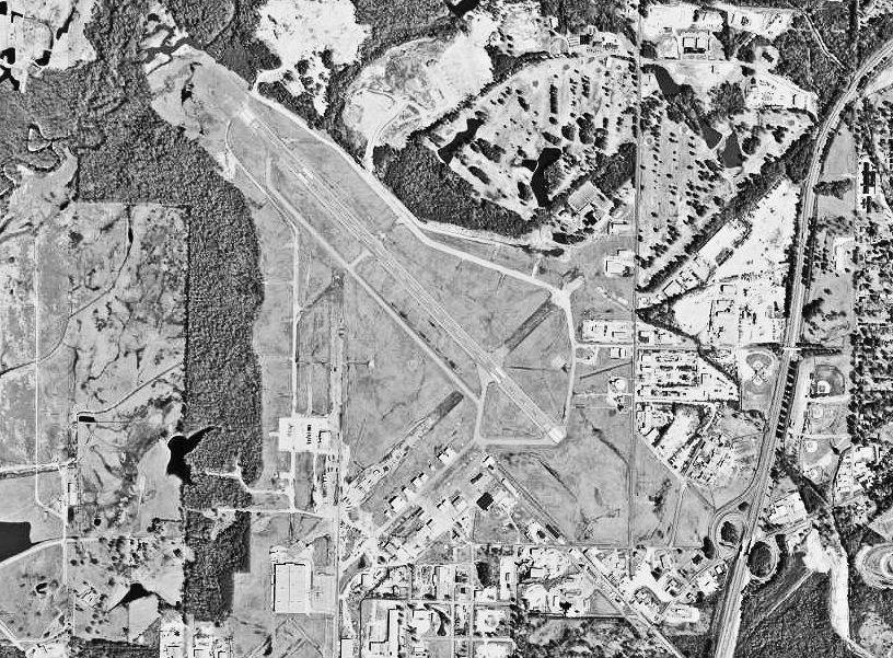
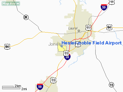
Hesler-Noble Field (IATA: LUL, ICAO: KLUL, FAA LID: LUL) is a public use airport located three nautical miles (6 km) southwest of the central business district of Laurel, a city in Jones County, Mississippi, United States. It is owned by Laurel Airport Authority. The airport serves the general aviation community, with no scheduled commercial airline service. HistoryLaurel Airport was first opened in April, 1940, having been constructed by the Works Project Administration, providing commercial airline service to the area. Alarmed by the fall of France in June 1940, Congress funded an increase in the strength of the United States Army Air Corps from 29 to 54 combat groups. The quickest way for the Air Corps to obtain additional bases was to utilize existing civil airports. The Air Corps signed an agreement to lease Laurel Airport, but because of technicalities in the land transfer, construction did not begin until mid 1942. Once begun, a large construction program was needed to turn the civil airport into a military airfield. Construction involved runways and airplane hangars, with three concrete runways, several taxiways and a large parking apron and a control tower. Several large hangars were also constructed. Buildings were ultimately utilitarian and quickly assembled. Most base buildings, not meant for long-term use, were constructed of temporary or semi-permanent materials. Although some hangars had steel frames and the occasional brick or tile brick building could be seen, most support buildings sat on concrete foundations but were of frame construction clad in little more than plywood and tarpaper. On 18 December 1942, Laurel Army Airfield was opened and assigned to the Third Air Force. The 473d Base Headquarters and Air Base Squadron was the host unit at the airfield Initially, the mission of the new Air Force field was to fly antisubmarine patrols over the Gulf of Mexico, with the 69th Observation Group flying light aircraft (Douglas O-38, Douglas O-46, North American O-47) from November 1942 until March 1943. In Mid-1943, Laurel AAF's mission changed to training medium and light bomber crews (B-25 Mitchell, A-20 Havoc) as well as photo reconnaissance units for deployment overseas. Known units that trained at the airfield were:
In early 1944, a phase down of training activity was began, and plans were made to convert Laurel AAF into a specialized storage facility. Most activities at the airfield were moved to Jackson Army Air Base and Laurel was transferred to Air Technical Service Command on 1 July 1944. Large numbers of aircraft were sent to Laurel, both from other training bases, and later from returning overseas units after the War. Excess aircraft were sent to reclamation facilities after being processed at Laurel. The airfield was placed on inactive status 31 May 1946 and returned to civil control. Hesler-Noble Field returned to being a civil airport until the early 1970s, when commercial airline service was shifted to Hattiesburg-Laurel Regional Airport in May 1974. Since then it has served the general aviation community. Facilities and aircraftHesler-Noble Field covers an area of 1,350 acres (546 ha) at an elevation of 238 feet (73 m) above mean sea level. It has one asphalt paved runway designated 13/31 which measures 5,513 by 150 feet (1,680 x 46 m). For the 12-month period ending June 4, 2008, the airport had 27,725 aircraft operations, an average of 75 per day: 96% general aviation and 4% military. At that time there were 40 aircraft based at this airport: 55% single-engine, 25% multi-engine, 13% jet and 8% ultralight. The above content comes from Wikipedia and is published under free licenses – click here to read more.
Location & QuickFacts
Owner & Manager
Airport Operations and Facilities
Airport Communications
Airport Services
Runway InformationRunway 13/31
Radio Navigation Aids
Remarks
Images and information placed above are from We thank them for the data!
We don't guarantee the information is fresh and accurate. The data may
be wrong or outdated.
|
|||||||||||||||||||||||||||||||||||||||||||||||||||||||||||||||||||||||||||||||||||||||||||||||||||||||||||||||||||||||||||||||||||||||||||||||||||||||||||||||||||||||||||||||||||||||||||||||||||||||||||||||||||||||||||||||||||||||||||||||||||||||||||||||||||||||||||||||||||||||||||||||||||||

 |
|
Copyright 2004-2024 © by Airports-Worldwide.com, Vyshenskoho st. 36, Lviv 79010, Ukraine Legal Disclaimer |