 |
|
Hernando Village Airpark Inc Airport |
Coordinates: 34°47′53.4″N 090°02′13.3″W / 34.798167°N 90.037028°W / 34.798167; -90.037028
| Hernando Village Airpark |
| IATA: none – ICAO: none – FAA LID: H75 |
| Summary |
| Airport type |
Open to Public |
| Owner/Operator |
Hernando Village Airpark Inc. |
| Serves |
Hernando, MS |
| Location |
Hernando, MS |
| Elevation AMSL |
242 ft / 73.8 m |
| Runways |
| Direction |
Length |
Surface |
| ft |
m |
| 14/32 |
3,340 |
1018.0 |
Turf |
| Statistics (2008) |
| Aircraft operations |
2,970 |
| Based aircraft |
12 |
| Sources: FAA |
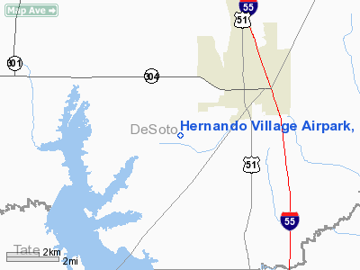
Hernando Village Airpark (FAA LID: H75) is a civil, privately-owned airport open to the public. It is located two miles (3 km) southwest of the central business district of Hernando, MS, a city in DeSoto County, Mississippi, United States. Hernando Village Airpark is an airport that is part of Green Village Residential Airpark in Hernando, MS. History
Hernando Village Airpark opened in 1988 by Diane and Bill Hawks of Mississippi. Their plan was to have a fly-in community, and, along with it, a place where pilots could taxi in along the grass strip runway and park their planes in a hangar on their own property. Two years later, they developed Green Village Residential Airpark by selling lots on 120 acres of their land just east of the airport in Hernando. The project encompasses 150 total acres with the airport and subdivision as of 1998.
Facilities and aircraft
Hernando Village Airpark rests on 40 acres. It has one turf runway 14/32 that is 3,340 x 65 feet (1018.0 x 19.8 m).
The Avgas and tie-down spaces are administered by the owner of Hernando Village Airpark.
Airlines and destinations
No regular service operates to or from Hernando Village Airpark.
The above content comes from Wikipedia and is published under free licenses – click here to read more.
Location & QuickFacts
| FAA Information Effective: | 2008-09-25 |
| Airport Identifier: | H75 |
| Airport Status: | Operational |
| Longitude/Latitude: | 090-02-13.3290W/34-47-53.3560N
-90.037036/34.798154 (Estimated) |
| Elevation: | 242 ft / 73.76 m (Estimated) |
| Land: | 40 acres |
| From nearest city: | 2 nautical miles SW of Hernando, MS |
| Location: | De Soto County, MS |
| Magnetic Variation: | 02E (1985) |
Owner & Manager
| Ownership: | Privately owned |
| Owner: | Hernando Village Airpark Inc |
| Address: | 2073 Greenhill Drive
Hernando, MS 38632 |
| Phone number: | 662-429-4302 |
| Manager: | Paul E. Cassel, Jr. |
| Address: | 2073 Greenhill Drive
Hernando, MS 38632 |
| Phone number: | 662-429-4302 |
Airport Operations and Facilities
| Airport Use: | Open to public |
| Wind indicator: | Yes |
| Segmented Circle: | No |
| Control Tower: | No |
| Lighting Schedule: | RDO-CTL
ACTVT LIRL RY 14/32 - CTAF. |
| Sectional chart: | Memphis |
| Region: | ASO - Southern |
| Boundary ARTCC: | ZME - Memphis |
| Tie-in FSS: | GWO - Greenwood |
| FSS on Airport: | No |
| FSS Toll Free: | 1-800-WX-BRIEF |
| NOTAMs Facility: | GWO |
Airport Communications
| CTAF: | 122.800 |
| Unicom: | 122.800 |
Airport Services
Runway Information
Runway 14/32
| Dimension: | 3340 x 65 ft / 1018.0 x 19.8 m |
| Surface: | TURF, Good Condition |
| Weight Limit: | Single wheel: 12000 lbs. |
| Edge Lights: | Low
RY 14/32 LIRL OTS INDEFLY. |
| |
Runway 14 |
Runway 32 |
| Traffic Pattern: | Left | Left |
| Obstruction: | 88 ft trees, 1680.0 ft from runway, 19:1 slope to clear | 177 ft tower, 2850.0 ft from runway, 120 ft left of centerline, 16:1 slope to clear |
|
Radio Navigation Aids
| ID |
Type |
Name |
Ch |
Freq |
Var |
Dist |
| ME | NDB | Elvis | | 287.00 | 01E | 15.9 nm |
| OLV | NDB | Olive Branch | | 275.00 | 01E | 16.4 nm |
| AWM | NDB | West Memphis | | 362.00 | 01E | 22.7 nm |
| SPQ | NDB | Spain | | 414.00 | 04E | 24.3 nm |
| MIG | NDB | Millington | | 232.00 | 04E | 29.3 nm |
| HEE | NDB | Thompson-robbins | | 251.00 | 01E | 34.4 nm |
| FCY | NDB | Forrest City | | 332.00 | 01E | 37.3 nm |
| CKM | NDB | Clarksdale | | 341.00 | 02E | 38.5 nm |
| FYE | NDB | Somerville | | 255.00 | 00E | 40.1 nm |
| UJM | VOR/DME | Marvell | 033X | 109.60 | 01E | 34.2 nm |
| GQE | VOR/DME | Gilmore | 077X | 113.00 | 04E | 39.5 nm |
| MEM | VORTAC | Memphis | 122X | 117.50 | 01E | 13.3 nm |
| HLI | VORTAC | Holly Springs | 071X | 112.40 | 03E | 26.7 nm |
| MEM | VOT | Memphis Metropolitn | | 111.00 | | 15.4 nm |
Images and information placed above are from
http://www.airport-data.com/airport/H75/
We thank them for the data!
| General Info
|
| Country |
United States
|
| State |
MISSISSIPPI
|
| FAA ID |
H75
|
| Latitude |
34-47-53.356N
|
| Longitude |
090-02-13.329W
|
| Elevation |
242 feet
|
| Near City |
HERNANDO
|
We don't guarantee the information is fresh and accurate. The data may
be wrong or outdated.
For more up-to-date information please refer to other sources.
|
|


