|
|
| Hawkins Field |
 |
| IATA: HKS – ICAO: KHKS – FAA LID: HKS |
| Summary |
| Airport type |
Public |
| Owner |
City of Jackson |
| Operator |
Jackson Metropolitan Airport Authority |
| Serves |
Jackson, Mississippi |
| Location |
Jackson, Mississippi |
| Elevation AMSL |
341 ft / 104 m |
| Coordinates |
32°20′05″N 090°13′21″W / 32.33472°N 90.2225°W / 32.33472; -90.2225 |
| Runways |
| Direction |
Length |
Surface |
| ft |
m |
| 16/34 |
5,387 |
1,642 |
Asphalt |
| 11/29 |
3,431 |
1,046 |
Concrete |
| Statistics (2007) |
| Aircraft operations |
62,516 |
| Based aircraft |
116 |
| Source: Federal Aviation Administration |
 | |
C-17 and emblem fo the 172d Airlift Wing |
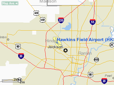
Hawkins Field (IATA: HKS, ICAO: KHKS, FAA LID: HKS) is a city-owned public-use airport located three miles (5 km) northwest of the central business district of Jackson, a city in Hinds County, Mississippi, United States. History
Hawkins Field traces its origins to February 1928, when the City of Jackson first acquired 151 acres (0.61 km) of land to designate as an airfield. The city bought the original parcel for $53,500, and the airport was originally called "Davis Field."
Hawkins Field was the terminus for Delta Air Lines' very first commercial flight in 1929.
In June 1941 Hawkins Field was designated as Jackson Army Airbase. It activated on 1 June 1942 and was used by the United States Army Air Force Flying Training Command, as a basic flying training airfield (Army Air Forces Pilot School, Miscellaneous Fields) (Basic; Advanced Single and Twin-Engine). The airfield also operated a contract Primary (level 1) flying school, by the Mississippi Institute of Aeronautics.
In addition, the Dutch government-in-exile, following the occupation of the Netherlands, established the Royal Netherlands Military Flying School at Hawkins Field, operating lend-lease aircraft, and training Dutch exiles as aircrews for service with Allied air forces in Europe and the Pacific.
The base was transferred to Third Air Force on 1 July 1944 with units being reassigned from Laurel Army Airfield to Jackson. Third Air Force operated the airfield as an Air Force Reserve training center (2588th Air Force Reserve Training Unit). It was not until 1949 that Hawkins was once again classified as a civilian airfield.
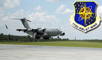
The Mississippi Air National Guard began using Hawkins Field in 1953. It has been a base for the 183d Squadron (under several designations) ever since, flying first reconnaissance (RB-26), and several generations of transport aircraft (C-124, C-130, C-141) and now the C-17 Globemaster III under the 172d Airlift Wing.
Facilities and aircraft
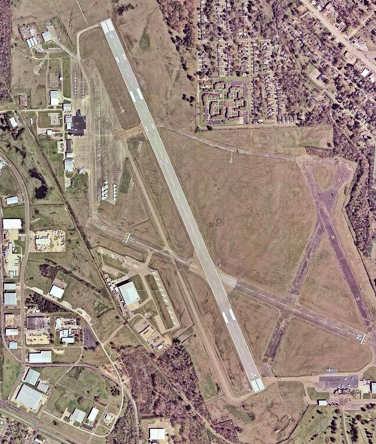
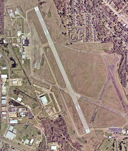
Hawkins Field covers an area of 602 acres (244 ha) which contains two runways: 16/34 with an asphalt surface measuring 5,387 x 150 ft (1,642 x 46 m) and 11/29 with a concrete surface measuring 3,431 x 150 ft (1,046 x 46 m).
For the 12-month period ending March 29, 2007, the airport had 62,516 aircraft operations, an average of 171 per day: 88% general aviation, 6% air taxi and 6% military. At that time there were 116 aircraft based at this airport: 40% single-engine (46), 32% multi-engine, 3% jet, 9% helicopter, 16% military.
The above content comes from Wikipedia and is published under free licenses – click here to read more.
Location & QuickFacts
| FAA Information Effective: | 2008-09-25 |
| Airport Identifier: | HKS |
| Airport Status: | Operational |
| Longitude/Latitude: | 090-13-21.1000W/32-20-05.2000N
-90.222528/32.334778 (Estimated) |
| Elevation: | 341 ft / 103.94 m (Surveyed) |
| Land: | 602 acres |
| From nearest city: | 3 nautical miles NW of Jackson, MS |
| Location: | Hinds County, MS |
| Magnetic Variation: | 02E (1990) |
Owner & Manager
| Ownership: | Publicly owned |
| Owner: | City Of Jackson |
| Address: |
Jackson, MS 39209 |
| Phone number: | 601-939-5631 |
| Manager: | Alvin Beamon |
| Address: | Po Box 98109
Jackson, MS 39298-8109 |
| Phone number: | 601-354-4983 |
Airport Operations and Facilities
| Airport Use: | Open to public |
| Wind indicator: | Yes |
| Segmented Circle: | Yes |
| Control Tower: | Yes |
| Lighting Schedule: | DUSK-DAWN
WHEN ATCT CLSD MIRL RY 11/29 UNAVBL, REIL RY 34 LEFT ON, ACTVT HIRL RY 16/34 AND MALSR RY 16 - CTAF. |
| Beacon Color: | Clear-Green (lighted land airport) |
| Sectional chart: | Memphis |
| Region: | ASO - Southern |
| Boundary ARTCC: | ZME - Memphis |
| Tie-in FSS: | GWO - Greenwood |
| FSS on Airport: | No |
| FSS Toll Free: | 1-800-WX-BRIEF |
| NOTAMs Facility: | HKS (NOTAM-d service avaliable) |
| Federal Agreements: | NGPY3 |
Airport Communications
| CTAF: | 119.650 |
| Unicom: | 122.950 |
Airport Services
| Fuel available: | 100LLA1+ |
| Airframe Repair: | MAJOR |
| Power Plant Repair: | MAJOR |
| Bottled Oxygen: | NONE |
| Bulk Oxygen: | NONE |
Runway Information
Runway 11/29
| Dimension: | 3431 x 150 ft / 1045.8 x 45.7 m |
| Surface: | CONC, Fair Condition |
| Weight Limit: | Single wheel: 30000 lbs.
Dual wheel: 40000 lbs.
Dual tandem wheel: 80000 lbs. |
| Edge Lights: | Medium |
| |
Runway 11 |
Runway 29 |
| Longitude: | 090-13-33.5369W | 090-12-57.1598W |
| Latitude: | 32-20-05.3873N | 32-19-51.2926N |
| Elevation: | 310.00 ft | 322.00 ft |
| Alignment: | 115 | 127 |
| Traffic Pattern: | Left | Left |
| Markings: | Basic, Fair Condition | Basic, Fair Condition |
| Obstruction: | 28 ft pline, 540.0 ft from runway, 12:1 slope to clear | 56 ft trees, 1693.0 ft from runway, 60 ft right of centerline, 26:1 slope to clear |
|
Runway 16/34
| Dimension: | 5387 x 150 ft / 1642.0 x 45.7 m |
| Surface: | ASPH, Good Condition |
| Surface Treatment: | Saw-cut or plastic Grooved |
| Weight Limit: | Single wheel: 30000 lbs.
Dual wheel: 40000 lbs.
Dual tandem wheel: 80000 lbs. |
| Edge Lights: | High |
| |
Runway 16 |
Runway 34 |
| Longitude: | 090-13-36.2159W | 090-13-13.4522W |
| Latitude: | 32-20-34.4010N | 32-19-44.7273N |
| Elevation: | 341.00 ft | 306.00 ft |
| Alignment: | 127 | 127 |
| ILS Type: | ILS
| |
| Traffic Pattern: | Left | Left |
| Markings: | Precision instrument, Good Condition | Precision instrument, Good Condition |
| VASI: | 4-light PAPI on left side | |
| Approach lights: | MALSR | |
| Runway End Identifier: | | Yes |
| Obstruction: | , 50:1 slope to clear | 42 ft trees, 1300.0 ft from runway, 210 ft left of centerline, 26:1 slope to clear |
|
Radio Navigation Aids
| ID |
Type |
Name |
Ch |
Freq |
Var |
Dist |
| JH | NDB | Brenz | | 260.00 | 02E | 5.1 nm |
| RYB | NDB | Raymond | | 375.00 | 03E | 9.8 nm |
| VKS | NDB | Vicksburg | | 382.00 | 03E | 36.3 nm |
| TV | NDB | Savry | | 344.00 | 02E | 41.2 nm |
| BVV | NDB | Brookhaven | | 407.00 | 03E | 44.7 nm |
| JAN | VORTAC | Jackson | 073X | 112.60 | 05E | 10.7 nm |
| JAN | VOT | Jackson | | 111.00 | | 8.1 nm |
Remarks
- RY 16/34 LIGHTS ON CONT STEP 3 - PCL OTS INDEFLY.
Images and information placed above are from
http://www.airport-data.com/airport/HKS/
We thank them for the data!
| General Info
|
| Country |
United States
|
| State |
MISSISSIPPI
|
| FAA ID |
HKS
|
| Latitude |
32-20-05.181N
|
| Longitude |
090-13-21.114W
|
| Elevation |
342 feet
|
| Near City |
JACKSON
|
We don't guarantee the information is fresh and accurate. The data may
be wrong or outdated.
For more up-to-date information please refer to other sources.
|
|