|
|
Hattiesburg-laurel Regional Airport |
| Hattiesburg-Laurel Regional Airport |
 |
| IATA: PIB – ICAO: KPIB |
| Summary |
| Airport type |
Public |
| Operator |
Regional Airport Authority |
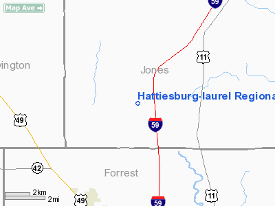
| Location |
Hattiesburg, Mississippi |
| Elevation AMSL |
298 ft / 90.8 m |
| Coordinates |
31°28′02″N 89°20′13″W / 31.46722°N 89.33694°W / 31.46722; -89.33694Coordinates: 31°28′02″N 89°20′13″W / 31.46722°N 89.33694°W / 31.46722; -89.33694 |
| Runways |
| Direction |
Length |
Surface |
| ft |
m |
| 18/36 |
6,501 |
1,982 |
Asphalt |
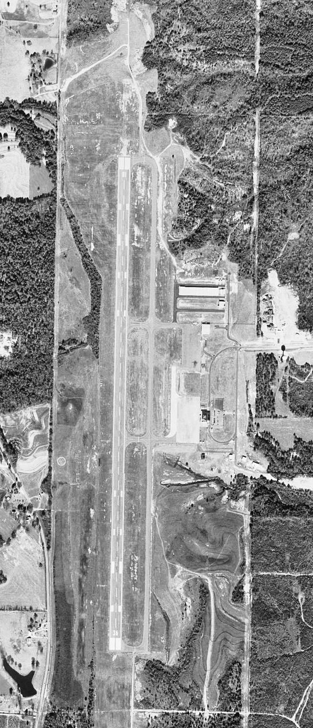
Hattiesburg-Laurel Regional Airport (IATA: PIB, ICAO: KPIB), nicknamed Airport City, is a public airport located approximately 10 miles north of Hattiesburg and 23 miles southwest of Laurel in the U.S. state of Mississippi. The airport covers 1,170 acres (473 ha) and has one runway. It is mostly used for general aviation, but is also served by one commercial airline. Service is subsidized by the Essential Air Service program.
The airport's code refers to the its former name, Pine Belt Regional Airport.
Hattiesburg is halfway between Mississippi's two major airports--Gulfport-Biloxi International Airport and Jackson-Evers International Airport. The three cities are linked by the four-lane U.S. Highway 49.
Airline
| Airlines |
Destinations |
| Delta Connection operated by Mesaba Airlines |
Memphis |
The above content comes from Wikipedia and is published under free licenses – click here to read more.
Location & QuickFacts
| FAA Information Effective: | 2008-09-25 |
| Airport Identifier: | PIB |
| Airport Status: | Operational |
| Longitude/Latitude: | 089-20-13.4000W/31-28-01.7000N
-89.337056/31.467139 (Estimated) |
| Elevation: | 298 ft / 90.83 m (Surveyed) |
| Land: | 1170 acres |
| From nearest city: | 9 nautical miles N of Hattiesburg/laurel, MS |
| Location: | Jones County, MS |
| Magnetic Variation: | 02E (1985) |
Owner & Manager
| Ownership: | Publicly owned |
| Owner: | Regional Airport Auth
HATTIESBURG-LAUREL REGIONAL AIRPORT AUTHORITY |
| Address: | 1002 Terminal Drive
Moselle, MS 39459 |
| Phone number: | 601-545-3111 |
| Manager: | Thomas Heanue |
| Address: | 1002 Terminal Drive
Moselle, MS 39459 |
| Phone number: | 601-545-3111 |
Airport Operations and Facilities
| Airport Use: | Open to public |
| Wind indicator: | Yes |
| Segmented Circle: | Yes |
| Control Tower: | No |
| Lighting Schedule: | DUSK-DAWN
HIRL RY 18/36 PRESET MED INTST; TO INCR INTST AND ACTVT PAPI RYS 18 & 36, MALSR RY 18 AND REILS RY 18 & 36 - CTAF. |
| Beacon Color: | Clear-Green (lighted land airport) |
| Landing fee charge: | No |
| Sectional chart: | New Orleans |
| Region: | ASO - Southern |
| Boundary ARTCC: | ZHU - Houston |
| Tie-in FSS: | GWO - Greenwood |
| FSS on Airport: | No |
| FSS Toll Free: | 1-800-WX-BRIEF |
| NOTAMs Facility: | PIB (NOTAM-d service avaliable) |
| Certification type/date: | I A S 06/1974
CLSD TO ACR OPNS WITH MORE THAN 30 PSGR SEATS EXCP 24 HR PPR, CALL ARPT MGR 601-545-3111. |
| Federal Agreements: | NGY |
Airport Communications
| CTAF: | 123.000 |
| Unicom: | 123.000 |
Airport Services
| Fuel available: | 100 A |
| Airframe Repair: | MINOR |
| Power Plant Repair: | MINOR |
| Bottled Oxygen: | NONE |
| Bulk Oxygen: | NONE |
Runway Information
Runway 18/36
| Dimension: | 6501 x 150 ft / 1981.5 x 45.7 m |
| Surface: | ASPH, Good Condition |
| Surface Treatment: | Saw-cut or plastic Grooved |
| Weight Limit: | Single wheel: 125000 lbs.
Dual wheel: 225000 lbs.
Dual tandem wheel: 275000 lbs. |
| Edge Lights: | High |
| |
Runway 18 |
Runway 36 |
| Longitude: | 089-20-13.4480W | 089-20-13.3667W |
| Latitude: | 31-28-33.9037N | 31-27-29.5549N |
| Elevation: | 298.00 ft | 294.00 ft |
| Alignment: | 127 | 127 |
| ILS Type: | ILS
| |
| Traffic Pattern: | Left | Left |
| Markings: | Precision instrument, Good Condition | Precision instrument, Good Condition |
| Crossing Height: | 60.00 ft | 59.00 ft |
| VASI: | 4-light PAPI on left side | 4-light PAPI on left side |
| Visual Glide Angle: | 3.00° | 3.00° |
| Approach lights: | MALSR | |
| Runway End Identifier: | Yes | Yes
4 BOX REIL |
| Decleard distances: | Take off run available 6501.00 ft
Take off distance available 6501.00 ft
Actual stop distance available 6501.00 ft
Landing distance available 6501.00 ft
| Take off run available 6501.00 ft
Take off distance available 6501.00 ft
Actual stop distance available 6501.00 ft
Landing distance available 6501.00 ft
|
|
Radio Navigation Aids
| ID |
Type |
Name |
Ch |
Freq |
Var |
Dist |
| THJ | NDB | Tallahala | | 346.00 | 00E | 15.2 nm |
| FOH | NDB | Foxworth | | 331.00 | 05E | 26.8 nm |
| BX | NDB | Carma | | 353.00 | 02E | 44.4 nm |
| LBY | VORTAC | Eaton | 043X | 110.60 | 05E | 2.9 nm |
| MCB | VORTAC | Mc Comb | 114X | 116.70 | 03E | 48.3 nm |
| GCV | VORTAC | Greene County | 104X | 115.70 | 05E | 49.0 nm |
Images and information placed above are from
http://www.airport-data.com/airport/PIB/
We thank them for the data!
| General Info
|
| Country |
United States
|
| State |
MISSISSIPPI
|
| FAA ID |
PIB
|
| Latitude |
31-28-01.700N
|
| Longitude |
089-20-13.400W
|
| Elevation |
298 feet
|
| Near City |
HATTIESBURG/LAUREL
|
We don't guarantee the information is fresh and accurate. The data may
be wrong or outdated.
For more up-to-date information please refer to other sources.
|
|