 |
|
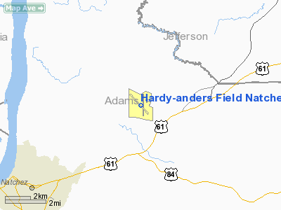
Hardy-anders Field Natchez-adams County Airport |
Natchez-Adams County Airport
Hardy-Anders Field |
| IATA: HEZ – ICAO: KHEZ – FAA LID: HEZ |
| Summary |
| Airport type |
Public |
| Owner |
Adams County |
| Serves |
Natchez, Mississippi |
| Elevation AMSL |
272 ft / 83 m |
| Coordinates |
31°36′49″N 091°17′50″W / 31.61361°N 91.29722°W / 31.61361; -91.29722 |
| Runways |
| Direction |
Length |
Surface |
| ft |
m |
| 13/31 |
6,500 |
1,981 |
Asphalt |
| 18/36 |
5,000 |
1,524 |
Asphalt |
| Statistics (2009) |
| Aircraft operations |
17,700 |
| Based aircraft |
33 |
| Source: Federal Aviation Administration |
Natchez-Adams County Airport (IATA: HEZ, ICAO: KHEZ, FAA LID: HEZ), also known as Hardy-Anders Field, is a county-owned public-use airport located six nautical miles (11 km) northeast of the central business district of Natchez, a city in Adams County, Mississippi, United States.
Facilities and aircraft
The airport covers an area of 900 acres (364 ha) at an elevation of 272 feet (83 m) above mean sea level. It has two asphalt paved runways: 13/31 is 6,500 by 150 feet (1,981 x 46 m) and 18/36 is 5,000 by 150 feet (1,524 x 46 m).
For the 12-month period ending January 31, 2009, the airport had 17,700 aircraft operations, an average of 48 per day: 93% general aviation, 5% air taxi, 2% military. At that time there were 33 aircraft based at this airport: 82% single-engine, 9% multi-engine, 6% jet and 3% helicopter.
The above content comes from Wikipedia and is published under free licenses – click here to read more.
|
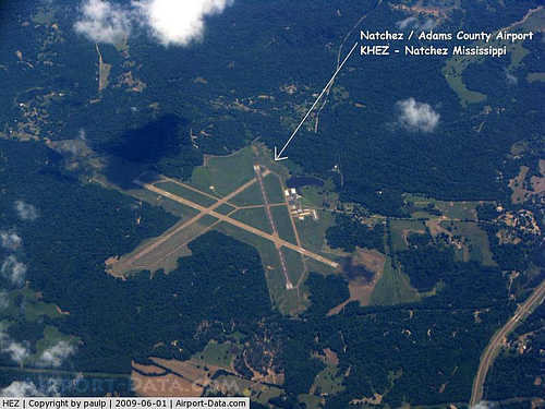 |
(Click on the photo to enlarge) |
Location & QuickFacts
| FAA Information Effective: | 2008-09-25 |
| Airport Identifier: | HEZ |
| Airport Status: | Operational |
| Longitude/Latitude: | 091-17-50.4110W/31-36-49.1800N
-91.297336/31.613661 (Estimated) |
| Elevation: | 272 ft / 82.91 m (Surveyed) |
| Land: | 900 acres |
| From nearest city: | 6 nautical miles NE of Natchez, MS |
| Location: | Adams County, MS |
| Magnetic Variation: | 03E (1985) |
Owner & Manager
| Ownership: | Publicly owned |
| Owner: | Adams County |
| Address: | Box 1008
Natchez, MS 39121 |
| Phone number: | 601-442-2431 |
| Manager: | Clinton B. Pomeroy |
| Address: | 434 Airport Rd
Natchez, MS 39120 |
| Phone number: | 601-442-5171 |
Airport Operations and Facilities
| Airport Use: | Open to public |
| Wind indicator: | Yes |
| Segmented Circle: | Yes |
| Control Tower: | No |
| Lighting Schedule: | DUSK-DAWN
ACTVT MIRL RY 18/36 & MALSR RY 13 & VASI RY 18 & PAPI RYS 13 & 31 - CTAF. |
| Beacon Color: | Clear-Green (lighted land airport) |
| Landing fee charge: | No |
| Sectional chart: | Houston |
| Region: | ASO - Southern |
| Boundary ARTCC: | ZHU - Houston |
| Tie-in FSS: | GWO - Greenwood |
| FSS on Airport: | No |
| FSS Toll Free: | 1-800-WX-BRIEF |
| NOTAMs Facility: | HEZ (NOTAM-d service avaliable) |
| Certification type/date: | IV A U 06/199
CLSD TO UNSKED AIR CARRIER OPNS WITH MORE THAN 30 PSGR SEATS EXCP 24 HRS PPR CALL AMGR 601-442-5171. |
| Federal Agreements: | NGY3 |
Airport Communications
| CTAF: | 122.800 |
| Unicom: | 122.800 |
Airport Services
| Fuel available: | 100LLA |
| Airframe Repair: | MAJOR |
| Power Plant Repair: | MAJOR |
| Bottled Oxygen: | NONE |
| Bulk Oxygen: | NONE |
Runway Information
Runway 13/31
| Dimension: | 6500 x 150 ft / 1981.2 x 45.7 m |
| Surface: | ASPH, Good Condition |
| Surface Treatment: | Saw-cut or plastic Grooved |
| Weight Limit: | Single wheel: 50000 lbs.
Dual wheel: 78000 lbs.
Dual tandem wheel: 172000 lbs. |
| Edge Lights: | High |
| |
Runway 13 |
Runway 31 |
| Longitude: | 091-18-21.2360W | 091-17-29.3280W |
| Latitude: | 31-37-14.0830N | 31-36-27.5570N |
| Elevation: | 262.00 ft | 269.00 ft |
| Alignment: | 127 | 127 |
| ILS Type: | ILS
| |
| Traffic Pattern: | Left | Left |
| Markings: | Precision instrument, Good Condition | Precision instrument, Good Condition |
| Crossing Height: | 54.00 ft | 42.00 ft |
| VASI: | 4-light PAPI on right side | 4-light PAPI on left side |
| Visual Glide Angle: | 3.00° | 3.00° |
| Approach lights: | MALSR | |
| Obstruction: | , 50:1 slope to clear | 78 ft trees, 2400.0 ft from runway, 250 ft right of centerline, 28:1 slope to clear |
|
Runway 18/36
| Dimension: | 5000 x 150 ft / 1524.0 x 45.7 m |
| Surface: | ASPH, Good Condition |
| Weight Limit: | Single wheel: 83000 lbs.
Dual wheel: 113000 lbs.
Dual tandem wheel: 65000 lbs. |
| Edge Lights: | Medium |
| |
Runway 18 |
Runway 36 |
| Longitude: | 091-17-43.6480W | 091-17-44.5120W |
| Latitude: | 31-37-11.7820N | 31-36-22.3110N |
| Elevation: | 270.00 ft | 260.00 ft |
| Alignment: | 127 | 1 |
| Traffic Pattern: | Left | Left |
| Markings: | Non-precision instrument, Good Condition | Non-precision instrument, Good Condition |
| Crossing Height: | 37.00 ft | 0.00 ft |
| VASI: | 2-box on left side | |
| Visual Glide Angle: | 3.00° | 0.00° |
| Obstruction: | , 50:1 slope to clear | 63 ft trees, 1400.0 ft from runway, 300 ft right of centerline, 19:1 slope to clear |
|
Radio Navigation Aids
| ID |
Type |
Name |
Ch |
Freq |
Var |
Dist |
| HAH | NDB | Natchez-adams County | | 388.00 | 03E | 4.6 nm |
| TV | NDB | Savry | | 344.00 | 02E | 40.4 nm |
| VKS | NDB | Vicksburg | | 382.00 | 03E | 41.8 nm |
| BVV | NDB | Brookhaven | | 407.00 | 03E | 45.4 nm |
| MC | NDB | Ferni | | 413.00 | 03E | 45.8 nm |
| HEZ | VOR/DME | Natchez | 037X | 110.00 | 03E | 0.3 nm |
Remarks
- GND PWR UNIT AVBL ON FILED.
- DEER ON & INVOF RYS.
Images and information placed above are from
http://www.airport-data.com/airport/HEZ/
We thank them for the data!
| General Info
|
| Country |
United States
|
| State |
MISSISSIPPI
|
| FAA ID |
HEZ
|
| Latitude |
31-36-49.180N
|
| Longitude |
091-17-50.411W
|
| Elevation |
272 feet
|
| Near City |
NATCHEZ
|
We don't guarantee the information is fresh and accurate. The data may
be wrong or outdated.
For more up-to-date information please refer to other sources.
|
|


