 |
|
Gulfport-biloxi International Airport |
| Gulfport-Biloxi International Airport |
 |
| IATA: GPT – ICAO: KGPT – FAA LID: GPT |
| Summary |
| Airport type |
Public |
| Owner |
Gulfport-Biloxi Regional Airport Authority |
| Serves |
Gulfport / Biloxi, Mississippi |
| Location |
Gulfport, Mississippi |
| Elevation AMSL |
28 ft / 9 m |
| Coordinates |
30°24′26″N 089°04′12″W / 30.40722°N 89.07°W / 30.40722; -89.07 |
| Website |
www.FlyGPT.com |
| Runways |
| Direction |
Length |
Surface |
| ft |
m |
| 14/32 |
9,002 |
2,744 |
Asphalt/Concrete |
| 18/36 |
4,935 |
1,504 |
Asphalt |
| Statistics (2008) |
| Aircraft operations |
54,545 |
| Based aircraft |
35 |
| Annual Passengers |
923,675 |
| Sources: airport web site and FAA |
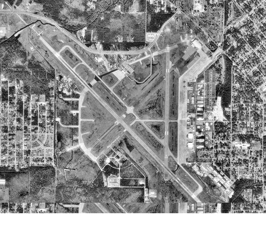
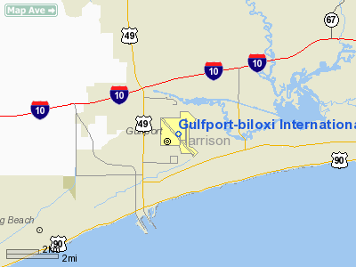
Gulfport-Biloxi International Airport (IATA: GPT, ICAO: KGPT, FAA LID: GPT) is a joint civil-military public use airport located three nautical miles (6 km) northeast of the central business district of Gulfport, a city in Harrison County, Mississippi, United States. It is owned by the Gulfport-Biloxi Regional Airport Authority.
In 2008, a total of 923,675 passengers utilized the airport, a 2.6% increase over 2007. Facilities and aircraft
Gulfport-Biloxi International Airport covers an area of 1,700 acres (6.9 km) at an elevation of 28 feet (9 m) above mean sea level. It has two runways: 14/32 with a 9,002 x 150 ft (2,744 x 46 m) asphalt/concrete surface and 18/36 with a 4,935 x 150 ft (1,504 x 46 m) asphalt surface. For the 12-month period ending December 31, 2006, the airport had 85,809 aircraft operations, an average of 235 per day: 62% general aviation, 19% military, 12% air taxi and 7% scheduled commercial. At that time there were 35 aircraft based at this airport: 46% single-engine, 23% multi-engine, 3% jet, 17% helicopter and 11% military.
Cargo Facility
A 40,000-square-foot (3,700 m) cargo facility will be completed by 4th Quarter 2008 at Gulfport-Biloxi International Airport. The cargo facility includes 20,000 square feet (1,900 m) of chiller space, 20,000 square feet (1,900 m) of cargo sorting and distribution space, and 6,000 square feet (560 m) of office space. Airside access from the runway system has been designed with safety and efficiency in mind. The ramp can facilitate two MD11s or DC10s or one B747. The area is also expandable with 120 acres (0.49 km) reserved for air cargo on airport property.
Airlines and destinations
GPT is currently served by 7 airlines to 8 cities (ATL, BKG, CLT, DFW, IAH, MEM, PIE, TPA).
| Airlines |
Destinations |
| AirTran Airways |
Atlanta, Tampa |
| American Eagle |
Dallas/Fort Worth |
| Branson Air Express operated by ExpressJet Airlines |
Branson |
| Continental Express operated by ExpressJet Airlines |
Houston-Intercontinental |
| Delta Air Lines |
Atlanta |
| Delta Connection operated by Atlantic Southeast Airlines |
Atlanta |
| Delta Connection operated by Pinnacle Airlines |
Memphis |
| Delta Connection operated by Shuttle America |
Atlanta, Memphis |
| US Airways Express operated by PSA Airlines |
Charlotte |
| Vision Airlines |
Charlotte, St. Petersburg/Clearwater |
Past scheduled airlines and cities.
- AirTran Airways service to Dallas/Ft. Worth, Ft. Lauderdale, Orlando, Houston (Hobby) and Nashville
- Allegiant service to Las Vegas, Sanford, St. Petersburg
- American Eagle service to Chicago O'hare
- Canada 3000 service to Toronto
- Continental Airlines service to Houston-Intercontinental
- Continental Express service to Jacksonville, Tampa
- Delta Connection service to Dallas/Ft. Worth, Orlando
- Myrtle Beach Direct Air operated by Xtra Airways service to St. Petersburg
- Northwest Airlines service to Memphis, TN
- Northwest Airlink operated by Pinnacle Airlines and Mesaba Airlines to Memphis, TN
- Reno Air service to Atlanta, Tampa, Sanford
- Skybus Airlines service to Columbus, OH, Greensboro, NC
- Southeast Airlines service to Sanford, St. Petersburg, Ft. Lauderdale, FL
- Southern Airways service to Columbus, GA
- Southern Skyways operated by AirTran Airways service to Atlanta
- Sun Country Airlines service to Minneapolis/ St Paul
- Vision Airlines service to Ft Lauderdale
Hurricane Katrina
The airport was closed for repairs (or reconstruction) following severe damage by Hurricane Katrina on August 29, 2005. On September 8, 2005, the airport reopened for commercial flights on Northwest Airlines to Memphis and other airlines quickly followed suit. On February 1, 2006, Gulfport-Biloxi International Airport was back to 100% of pre-Katrina seats. As of September 12, 2006, the Airport was at 120% of seats available pre-Katrina. Currently, the airport is thriving with many non-stop flights to numerous destinations, and is undergoing extensive renovation scheduled for completion in 2007. All pre-Katrina carriers are back in operation as well as new carriers.
History
The airport was originally constructed in 1942 by the United States Army Air Forces as a training base for Air Corps Flying Training Command. Gulfport Army Airfield opened on 7 July, and the Eastern Technical Training Command conducted technical training and basic training until transferred to Third Air Force on 31 March 1944 with joint use by Technical Training Command for marine training of Emergency Rescue School (3d Air Rescue Group) located at Keesler Army Airbase.
Under Second Air Force, the 328th Army Air Force Base Unit conducted replacement training for heavy bomber (B-17 Flying Fortress, B-24 Liberator) units. In addition B-29 Superfortress aircrew transition training was performed. With the end of the war and the drawdown of the military, Gulfport AAF was placed into reserve status on 31 January 1946.
Gulfport Field was declared excess by the Air Force and conveyed by the War Assets Administration to the City of Gulfport in 1949 for use as a civil airport. The City negotiated airline service contracts with Southern Airways and later National Airlines to provide passenger and cargo service beginning in the early 1950s.
Due to the large expansion of the United States Air Force as a result of the Cold War, a new lease was obtained for military use of the airport and Gulfport Air Force Base was opened as a joint-use civil/military facility. Improvements were made by the Air Force to the field to bring the wartime facilities up to permanent Air Force standards. On 16 July 1951. Gulfport Air Force Base was activated and assigned to the Air Training Command (ATC) and was made the headquarters of the new Technical Training Air Force (TTAF), which controlled technical and basic training of Air Force personnel. The TTAF controlled 10 Air Force wings from Gulfport:
7 Technical Training wings:
- 3310th, Scott AFB, Illinois
- 3320th, Amarillo AFB, Texas
- 3345th, Chanute AFB, Illinois
- 3380th, Keesler AFB, Mississippi
- 3415th, Lowry AFB, Colorado
- 3450th, Francis E. Warren AFB, Wyoming
- 3750th, Sheppard AFB, Texas
1 USAF Recruiting Wing: 3500th, Wright-Patterson AFB, Ohio
1 USAF Military Basic Training Wing: 3700th, Lackland AFB, Texas
1 USAF Mobile Training Wing: 3499th, Chanute AFB, Illinois
In addition, contract basic flying training was conducted at Gulfport.
In 1957, ATC decided to assign all flying and crew training responsibilities under a single headquarters. In addition, effective 1 July 1958, the command discontinued the Technical Training Air Force and moved all training headquarters to their controlling major commands or to ATC, depending on its mission. Recruiting and Basic Training were also reassigned to HQ ATC. Gulfport AFB was closed as an active Air Force installation and its military facilities were transferred to the Mississippi Air National Guard, with the airport remainnig a joint-use airport and Air National Guard base.
Through the late 1970s, Southern Airways continued as the primary airline, followed by successors Republic Airlines and Northwest Airlines into the 1990s. Beginning in 1953, the Mississippi Air National Guard developed a training activity which has grown into a high-tech Combat Readiness Training Center, one of four in the Nation. Military traffic has expanded each year, and now more than 20,000 Air National Guard and Air Force Reserve flight personnel are trained at the base annually. Within 10 minutes, supersonic fighters and in-flight refuelers can simulate a combat environment over the Gulf of Mexico or at Camp Shelby in Hattiesburg, MS. Additionally, the Army National Guard established the Aviation Classification Repair Depot operation which repairs several types of combat and transport helicopters for military activities throughout the Southeast and Puerto Rico.
The above content comes from Wikipedia and is published under free licenses – click here to read more.
Location & QuickFacts
| FAA Information Effective: | 2008-09-25 |
| Airport Identifier: | GPT |
| Airport Status: | Operational |
| Longitude/Latitude: | 089-04-12.3485W/30-24-26.1677N
-89.070097/30.407269 (Estimated) |
| Elevation: | 28 ft / 8.53 m (Surveyed) |
| Land: | 1400 acres |
| From nearest city: | 3 nautical miles NE of Gulfport, MS |
| Location: | Harrison County, MS |
| Magnetic Variation: | 02E (1985) |
Owner & Manager
| Ownership: | Publicly owned |
| Owner: | Gulfport-biloxi Rgnl Apt Auth |
| Address: | 14035-l Airport Rd
Gulfport, MS 39503 |
| Phone number: | 228-863-5951 |
| Manager: | Mr. Bruce A Frallic
EXECUTIVE DIRECTOR |
| Address: | 14035-l Airport Rd
Gulfport, MS 39503 |
| Phone number: | 228-863-5951 |
Airport Operations and Facilities
| Airport Use: | Open to public |
| Wind indicator: | Yes |
| Segmented Circle: | Yes |
| Control Tower: | Yes |
| Lighting Schedule: | DUSK-DAWN
WHEN ATCT CLSD, ACTVT HIRL RY 14/32, VASI RYS 18 & 36, REIL RY 14/32 & 18/36, MALSR RY 14 AND MALSR RY 32 - CTAF. MIRL RY 18/36 NOT AVBL WHEN ATCT CLSD. |
| Beacon Color: | Clear-Green (lighted land airport) |
| Landing fee charge: | No |
| Sectional chart: | New Orleans |
| Region: | ASO - Southern |
| Boundary ARTCC: | ZHU - Houston |
| Tie-in FSS: | GWO - Greenwood |
| FSS on Airport: | No |
| FSS Toll Free: | 1-800-WX-BRIEF |
| NOTAMs Facility: | GPT (NOTAM-d service avaliable) |
| Certification type/date: | I B S 05/1973 |
| Federal Agreements: | NGPY3 |
Airport Communications
| CTAF: | 123.700 |
| Unicom: | 122.950 |
Airport Services
| Fuel available: | 100LLA |
| Airframe Repair: | MAJOR |
| Power Plant Repair: | MAJOR |
| Bottled Oxygen: | NONE |
| Bulk Oxygen: | NONE |
Runway Information
Runway 14/32
| Dimension: | 9002 x 150 ft / 2743.8 x 45.7 m |
| Surface: | ASPH-CONC, Good Condition |
| Surface Treatment: | Saw-cut or plastic Grooved |
| Weight Limit: | Single wheel: 60000 lbs.
Dual wheel: 155000 lbs.
Dual tandem wheel: 265000 lbs. |
| Edge Lights: | High |
| |
Runway 14 |
Runway 32 |
| Longitude: | 089-04-56.2973W | 089-03-43.5087W |
| Latitude: | 30-24-53.8368N | 30-23-50.9251N |
| Elevation: | 19.00 ft | 22.00 ft |
| Alignment: | 127 | 127 |
| ILS Type: | ILS
| ILS
|
| Traffic Pattern: | Left | Left |
| Markings: | Precision instrument, Good Condition | Precision instrument, Good Condition |
| Arresting: | BAK14 | BAK14 |
| Crossing Height: | 60.00 ft | 47.00 ft |
| VASI: | 4-light PAPI on right side | 4-light PAPI on left side |
| Visual Glide Angle: | 3.00° | 3.00° |
| RVR Equipment: | touchdown | |
| Approach lights: | MALSR | MALSR |
| Runway End Identifier: | Yes | Yes |
| Obstruction: | 50 ft trees, 1900.0 ft from runway, 300 ft right of centerline, 34:1 slope to clear | 70 ft tower, 2100.0 ft from runway, 27:1 slope to clear |
|
Runway 18/36
| Dimension: | 4935 x 150 ft / 1504.2 x 45.7 m |
| Surface: | ASPH, Fair Condition |
| Weight Limit: | Single wheel: 20000 lbs.
Dual tandem wheel: 115000 lbs. |
| Edge Lights: | Medium |
| |
Runway 18 |
Runway 36 |
| Longitude: | 089-03-58.6495W | 089-03-58.4870W |
| Latitude: | 30-24-57.4986N | 30-24-08.6519N |
| Elevation: | 24.00 ft | 26.00 ft |
| Alignment: | 127 | 127 |
| Traffic Pattern: | Left | Left |
| Markings: | Non-precision instrument, Good Condition | Non-precision instrument, Good Condition |
| Crossing Height: | 44.00 ft | 34.00 ft |
| VASI: | 4-box on right side | 4-box on left side |
| Visual Glide Angle: | 3.00° | 3.00° |
| Runway End Identifier: | Yes | Yes |
| Obstruction: | 42 ft tree, 1300.0 ft from runway, 200 ft right of centerline, 25:1 slope to clear | 40 ft trees, 1800.0 ft from runway, 40:1 slope to clear |
|
Radio Navigation Aids
| ID |
Type |
Name |
Ch |
Freq |
Var |
Dist |
| HS | NDB | Hanco | | 221.00 | 01E | 20.1 nm |
| AYI | NDB | Hanco | | 221.00 | 03E | 20.1 nm |
| MJD | NDB | Picayune | | 276.00 | 01E | 30.7 nm |
| FNA | NDB | Florenville | | 371.00 | 03E | 38.9 nm |
| DEF | NDB | Slidell | | 256.00 | 03E | 40.2 nm |
| MO | NDB | Wisle | | 248.00 | 02E | 45.0 nm |
| BX | NDB | Carma | | 353.00 | 02E | 49.9 nm |
| BIX | TACAN | Keesler | 055X | | 01E | 7.3 nm |
| GPT | VOR/DME | Gulfport | 27X | 109.00 | 02E | 0.3 nm |
| PCU | VOR/DME | Picayune | 059X | 112.20 | 05E | 35.4 nm |
| SJI | VORTAC | Semmes | 100X | 115.30 | 05E | 41.5 nm |
Remarks
- NUMEROUS LOW FLYING FISH SPOTTER ACFT OPERG THE SHORELINE BETWEEN PASCAGOULA & GULFPORT SR-SS.
- ACFT OPERG AS SKED OR CHARTER PSGR SVC SHALL NOT TAXI ON TWY 'A' NORTH OF TWY 'B' INTXN WITHOUT ESCORT FROM GND HANDLING AGENT OR ARPT AUTH.
- CIVIL ACFT WITH WING SPAN OF 132 FT OR GREATER AND ALL ACR ACFT MUST BE ESCORTED ALONG TWY 'A' NORTH OF TWY 'C' BY GND HANDLING AGENT.
- MIL ACFT OR ACFT SUPPORTING A MIL MISSION WITH WING SPAN OF 132 FT OR GREATER MUST HAVE ESCORT OR COORD TAXI PROCEDURES WITH GND HANDLING AGENT PRIOR TO TAXIING ON TWY 'A'.
- MAVERICK PAD APRON AREA ON N END OF TWY C RESTRICTED TO MILITARY ARCFT USE ONLY.
- ACFT OVER 115,000 LBS ARE RSTRD FM 180 DEG TURNS ON ASPH PORTION OF RY 18/36. ACFT WITH WINGSPAN GREATER THAN 223 FT ARE RSTRD FM OPERATING ON TWY 'C' BTN TWY 'A' AND AER 32.
- ACFT OVER 155000 LBS ARE RSTRD FM USING THE N PART OF TWY 'A' AT RY 18/36. ACFT OVER 316000 LBS ARE RSTRD FM USING THE S PART OF TWY 'A' BTN TWY 'C' & RY 14/32.
- DUE TO APRON ACTIVITY ACFT WITH WINGSPAN GREATER THAN 170 FT SHOULD BE ALERT ON TWY 'A' BTN TWY 'C' & TWY 'B'.
- TWY F CLSD INDEFLY.
- 150 FT AGL CRANE 4600 FT N OF RY 18 THLD.
- EXISTED PRIOR TO 1959.
Images and information placed above are from
http://www.airport-data.com/airport/GPT/
We thank them for the data!
| General Info
|
| Country |
United States
|
| State |
MISSISSIPPI
|
| FAA ID |
GPT
|
| Latitude |
30-24-26.200N
|
| Longitude |
089-04-12.400W
|
| Elevation |
28 feet
|
| Near City |
GULFPORT
|
We don't guarantee the information is fresh and accurate. The data may
be wrong or outdated.
For more up-to-date information please refer to other sources.
|
|


