 |
|
Grenada Municipal Airport |
| Grenada Municipal Airport |
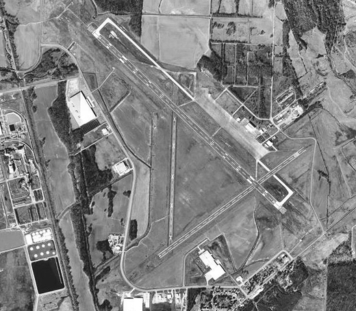 |
| USGS aerial photo, 11 February 1996 |
| IATA: none – ICAO: KGNF – FAA LID: GNF |
| Summary |
| Airport type |
Public |
| Owner |
City of Grenada |
| Serves |
Grenada, Mississippi |
| Elevation AMSL |
208 ft / 63 m |
| Coordinates |
33°49′57″N 089°47′54″W / 33.8325°N 89.79833°W / 33.8325; -89.79833 |
| Runways |
| Direction |
Length |
Surface |
| ft |
m |
| 13/31 |
7,000 |
2,134 |
Asphalt |
| 4/22 |
5,000 |
1,524 |
Asphalt |
| Statistics (2009) |
| Aircraft operations |
16,051 |
| Based aircraft |
15 |
| Source: Federal Aviation Administration |
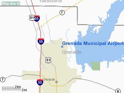
Grenada Municipal Airport (ICAO: KGNF, FAA LID: GNF) is a city-owned public use airport located three nautical miles (6 km) north of the central business district of Grenada, a city in Grenada County, Mississippi, United States. The airport serves the general aviation community, with no scheduled commercial airline service.
Although most U.S. airports use the same three-letter location identifier for the FAA and IATA, this airport is assigned GNF by the FAA but has no designation from the IATA. History
Built during 1943, the airport was known as the Grenada Army Airfield during World War II, the United States Army Air Force Army Air Forces Training Command.
Grenada Army Airfield's primary mission was described as follows: A. The deliver Army ground force combat teams at strategic points by: a. Parachute troops and equipment b. Delivering gliders with troops and equipment B. The field's secondary mission was: a. Reinforcement and re-supply of ground troops b. Evacuation of wounded
The field consisted of three runways - all of which were approximately 5000 feet long. The ramp and taxi strips were concrete-ramp being 500 feet by 3000 feet long. By the time the program was completed, fifty C-47 airplanes and 25 CG-4A gliders were brought to Grenada field to be serviced and prepared for use.
Troop Carrier Command assigned the following groups to the airfield for the purpose of training replacement crews.
- 63d Troop Carrier Group, 3 June 1943-10 January 1944
- 10th Troop Carrier Group, 21 January-8 March 1944
The headquarters unit on the airfield was the 443d Base Headquarters Squadron. In 1953 the airfield was turned over to the City of Grenada and became known as the Grenada Municipal Airport. The military has since made improvements to the field and jointly uses it with civil aviation.
Facilities and aircraft
Grenada Municipal Airport covers an area of 656 acres (265 ha) at an elevation of 208 feet (63 m) above mean sea level. It has two asphalt paved runways: 13/31 is 7,000 by 150 feet (2,134 x 46 m) and 4/22 is 5,000 by 100 feet (1,524 x 30 m).
For the 12-month period ending February 17, 2009, the airport had 16,051 aircraft operations, an average of 43 per day: 71% general aviation and 29% military. At that time there were 15 aircraft based at this airport: 93% single-engine and 7% multi-engine.
The above content comes from Wikipedia and is published under free licenses – click here to read more.
Location & QuickFacts
| FAA Information Effective: | 2008-09-25 |
| Airport Identifier: | GNF |
| Airport Status: | Operational |
| Longitude/Latitude: | 089-47-53.6200W/33-49-57.1100N
-89.798228/33.832531 (Estimated) |
| Elevation: | 208 ft / 63.40 m (Surveyed) |
| Land: | 656 acres |
| From nearest city: | 3 nautical miles N of Grenada, MS |
| Location: | Grenada County, MS |
| Magnetic Variation: | 01E (1995) |
Owner & Manager
| Ownership: | Publicly owned |
| Owner: | City Of Grenada |
| Address: | Po Box 310
Grenada, MS 38901 |
| Phone number: | 662-227-3440 |
| Manager: | Sidney Runnels
CITY MANAGER - 662-227-3440. |
| Address: | , Po Box 310
Grenada, MS 38901 |
| Phone number: | 662-227-8402 |
Airport Operations and Facilities
| Airport Use: | Open to public |
| Wind indicator: | Yes |
| Segmented Circle: | Yes |
| Control Tower: | No |
| Lighting Schedule: | DUSK-DAWN |
| Beacon Color: | Clear-Green (lighted land airport) |
| Landing fee charge: | No |
| Sectional chart: | Memphis |
| Region: | ASO - Southern |
| Boundary ARTCC: | ZME - Memphis |
| Tie-in FSS: | GWO - Greenwood |
| FSS on Airport: | No |
| FSS Toll Free: | 1-800-WX-BRIEF |
| NOTAMs Facility: | GWO (NOTAM-d service avaliable) |
| Federal Agreements: | NGPY |
Airport Communications
| CTAF: | 122.800 |
| Unicom: | 122.800 |
Airport Services
| Fuel available: | 100LLA |
| Bottled Oxygen: | NONE |
| Bulk Oxygen: | NONE |
Runway Information
Runway 04/22
| Dimension: | 5000 x 100 ft / 1524.0 x 30.5 m
200 FT BY 150 FT ASPH OVERRUN AT BOTH RY ENDS. |
| Surface: | ASPH, Good Condition |
| Weight Limit: | Single wheel: 60000 lbs.
Dual wheel: 200000 lbs.
Dual tandem wheel: 300000 lbs. |
| |
Runway 04 |
Runway 22 |
| Longitude: | 089-48-07.8300W | 089-47-21.2200W |
| Latitude: | 33-49-28.5700N | 33-49-59.1200N |
| Elevation: | 193.00 ft | 201.00 ft |
| Alignment: | 52 | 127 |
| Traffic Pattern: | Left | Left |
| Markings: | Basic, Fair Condition | Basic, Fair Condition |
| Displaced threshold: | 0.00 ft | 225.00 ft |
| Obstruction: | 71 ft trees, 1320.0 ft from runway, 15:1 slope to clear | 15 ft road, 200.0 ft from runway, 225 ft right of centerline
APCH RATIO 28:1 TO DSPLCD THLD.
PAVED ROAD, 200' FROM RWY END, 225' RIGHT & 167' LEFT. |
|
Runway 13/31
| Dimension: | 7000 x 150 ft / 2133.6 x 45.7 m
200 FT BY 150 FT ASPH OVERRUN AT BOTH RY ENDS. |
| Surface: | ASPH, Good Condition |
| Weight Limit: | Single wheel: 60000 lbs.
Dual wheel: 200000 lbs.
Dual tandem wheel: 300000 lbs. |
| Edge Lights: | Medium
MIRL PRESET ON MED INTST. |
| |
Runway 13 |
Runway 31 |
| Longitude: | 089-48-30.6800W | 089-47-28.8600W |
| Latitude: | 33-50-29.1500N | 33-49-42.9700N |
| Elevation: | 208.00 ft | 197.00 ft |
| Alignment: | 127 | 127 |
| ILS Type: | ILS/DME
| |
| Traffic Pattern: | Left | Left |
| Markings: | Precision instrument, Good Condition | Precision instrument, Good Condition |
| Crossing Height: | 52.00 ft | 56.00 ft |
| VASI: | 4-box on left side | 4-box on left side |
| Visual Glide Angle: | 3.00° | 3.00° |
| Approach lights: | MALSR | |
| Obstruction: | , 50:1 slope to clear | 72 ft trees, 2350.0 ft from runway, 29:1 slope to clear |
|
Radio Navigation Aids
| ID |
Type |
Name |
Ch |
Freq |
Var |
Dist |
| SBQ | NDB | Scobey | | 245.00 | 01E | 5.2 nm |
| CKM | NDB | Clarksdale | | 341.00 | 02E | 45.2 nm |
| OSX | NDB | Kosciusko | | 269.00 | 00W | 46.4 nm |
| RNV | NDB | Renova | | 272.00 | 04E | 48.2 nm |
| IDL | NDB | Indianola | | 284.00 | 03E | 48.7 nm |
| SQS | VORTAC | Sidon | 094X | 114.70 | 03E | 32.6 nm |
Remarks
- EXTENSIVE AGRICULTURE OPNS INVOF ARPT SR-SS BTN MAR-OCT ANNUALLY.
- MIGRATORY BIRDS AND DEER INVOF ARPT.
- GCO AVBL ON FREQ 121.72 THRU GWO AFSS.
- PRIOR TO FAA ACT.
Images and information placed above are from
http://www.airport-data.com/airport/GNF/
We thank them for the data!
| General Info
|
| Country |
United States
|
| State |
MISSISSIPPI
|
| FAA ID |
GNF
|
| Latitude |
33-49-57.108N
|
| Longitude |
089-47-53.621W
|
| Elevation |
208 feet
|
| Near City |
GRENADA
|
We don't guarantee the information is fresh and accurate. The data may
be wrong or outdated.
For more up-to-date information please refer to other sources.
|
|


