 |
|
Golden Triangle Regional Airport |
| Golden Triangle Regional Airport |
| IATA: GTR – ICAO: KGTR |
| Summary |
| Airport type |
Public |
| Operator |
Golden Triangle Regional Authority |
| Location |
Golden Triangle (Mississippi) |
| Elevation AMSL |
264 ft / 80.5 m |
| Coordinates |
33°27′01.2″N 88°35′28.92″W / 33.450333°N 88.5913667°W / 33.450333; -88.5913667Coordinates: 33°27′01.2″N 88°35′28.92″W / 33.450333°N 88.5913667°W / 33.450333; -88.5913667 |
| Runways |
| Direction |
Length |
Surface |
| ft |
m |
| 18/36 |
6,497 |
1,980 |
Asphalt |
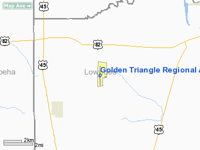
Golden Triangle Regional Airport (IATA: GTR, ICAO: KGTR) is a public airport midway between the towns of Columbus, Starkville, and West Point, Mississippi, and serving the area known as the Golden Triangle and the surrounding region of Mississippi. The airport has a single runway.
GTR is mostly used for general and military aviation but is also served by one commercial airline, Atlantic Southeast Airlines, under the auspices of Delta Connection (although Delta sold ASA to SkyWest in September 2005). Chautauqua Airlines, a Republic Airways Holdings company, also operated flights under the Delta Connection banner early in 2006. Until Delta's withdrawing "focus city" operations from Dallas-Fort Worth in February 2005, GTR had one flight per day to DFW. Four ASA flights per day to Atlanta's Hartsfield-Jackson International Airport remained until late 2005. In 2006, there are but three flights per day to ATL.
Mesaba Aviation, d.b.a. Northwest Airlink, also operated flights to Memphis from GTR, but they ceased these operations in 2003 citing a desire to not compete with the new regional jet service being started by ASA as they replaced the Embraer fleet.
With the acquisition of Northwest Airlines by Delta Air Lines in 2008 Delta took over scheduling the Northwest flights in the Memphis hub. On January 27, 2009 Delta announced the resumption of service between GTR and Memphis on Mesaba Airlines, now operating as a Delta Connection carrier. The new service begins on May 4th and supplements the Atlantic Southeast Airlines service to Atlanta.
GTR is the nucleus of a new industrial complex in northeast Mississippi. American Eurocopter, a subsidiary of EADS North America, moved into an 85,000-square-foot (7,900 m) helicopter production plant built by the airport and leased to the company on airport property in 2004. In 2007 American Eurocopter finshed the second phase of the project, a 220,000-square-foot (20,000 m) facility built primarily to manufacture and assemble the new U.S. Army UH-72A Lakota Light Utility Helicopter. Aurora Flight Sciences, a high-tech UAV manufacturer completed a manufacturing facility in 2005 and is expected to open the second phase of the facility in late 2008. SeverCorr opened a steel mini-mill in an adjacent site in October 2007 and immediately began construction on phase II, bringing total investment in the plant to $1.6 billion. PACCAR, parent company of Peterbilt, Kenworth and DAF (Dutch) trucks is constructing a truck engine plant adjacent to the airport to the north that is expected to open in 2009. Other industry, many with international roots, continues to locate at the industrial park adjacent to the airport. The area has two "megasites" adjacent to the airport that were certified under the Tennessee Valley Authority's Certified Megasite program.
Because of the projected growth, in the five years since 2003 the airport has spent significant resources improving and upgrading the infrastructure. In 2003 a $1.6 million air traffic control tower was opened to maintain the safety of the flying operation and is manned under the FAA's Contract Tower Program. The runway was repaved and strengthened to take commercial aircraft up to a Boeing 757. Two additional parking ramps were constructed and the two remaining ramps were rehabilitated. The terminal has had minor renovations but a major expansion is planned for 2009. GTRA is attempting to expand their runway from 6,497 to 8,000 feet (2,400 m).
Airlines
| Airlines |
Destinations |
| Delta Connection operated by Atlantic Southeast Airlines |
Atlanta |
| Delta Connection operated by Mesaba Airlines |
Atlanta, Memphis |
The above content comes from Wikipedia and is published under free licenses – click here to read more.
Location & QuickFacts
| FAA Information Effective: | 2008-09-25 |
| Airport Identifier: | GTR |
| Airport Status: | Operational |
| Longitude/Latitude: | 088-35-28.9000W/33-27-01.2000N
-88.591361/33.450333 (Estimated) |
| Elevation: | 264 ft / 80.47 m (Surveyed) |
| Land: | 800 acres |
| From nearest city: | 10 nautical miles W of Columbus/w Point/starkville, MS |
| Location: | Lowndes County, MS |
| Magnetic Variation: | 01E (1985) |
Owner & Manager
| Ownership: | Publicly owned |
| Owner: | Golden Triangle Reg Auth |
| Address: | 2080 Airport Rd - Hiway 82w
Columbus, MS 39701 |
| Phone number: | 662-327-4422 |
| Manager: | Mike Hainsey |
| Address: | 2080 Airport Rd - Hiway 82w
Columbus, MS 39701 |
| Phone number: | 662-327-4422
EXT 201 |
Airport Operations and Facilities
| Airport Use: | Open to public |
| Wind indicator: | Yes |
| Segmented Circle: | Yes |
| Control Tower: | Yes |
| Lighting Schedule: | DUSK-DAWN
ACTVT HIRL RY 18/36, MALSR RY 18; REIL RY 36 & TWY LGTS - 118.2. |
| Beacon Color: | Clear-Green (lighted land airport) |
| Landing fee charge: | No |
| Sectional chart: | Memphis |
| Region: | ASO - Southern |
| Boundary ARTCC: | ZME - Memphis |
| Tie-in FSS: | GWO - Greenwood |
| FSS on Airport: | No |
| FSS Toll Free: | 1-800-WX-BRIEF |
| NOTAMs Facility: | GTR (NOTAM-d service avaliable) |
| Certification type/date: | I A S 05/1973 |
| Federal Agreements: | NGY |
Airport Communications
| CTAF: | 118.200 |
| Unicom: | 122.950 |
Airport Services
| Fuel available: | 100LLA |
| Airframe Repair: | MINOR |
| Power Plant Repair: | MINOR |
Runway Information
Runway 18/36
| Dimension: | 6497 x 150 ft / 1980.3 x 45.7 m |
| Surface: | ASPH, Good Condition |
| Pavement Class: | 30 /F/B/Y/T |
| Weight Limit: | Single wheel: 133000 lbs.
Dual wheel: 200000 lbs.
Dual tandem wheel: 300000 lbs. |
| Edge Lights: | High |
| |
Runway 18 |
Runway 36 |
| Longitude: | 088-35-28.6199W | 088-35-29.2540W |
| Latitude: | 33-27-33.3473N | 33-26-29.0640N |
| Elevation: | 260.00 ft | 256.00 ft |
| Alignment: | 127 | 0 |
| ILS Type: | ILS
| |
| Traffic Pattern: | Left | Left |
| Markings: | Precision instrument, Good Condition | Precision instrument, Good Condition |
| Crossing Height: | 56.00 ft | 56.00 ft |
| VASI: | 4-box on left side | 4-box on left side |
| Visual Glide Angle: | 3.00° | 3.00° |
| Approach lights: | MALSR | |
| Runway End Identifier: | | Yes |
|
Radio Navigation Aids
| ID |
Type |
Name |
Ch |
Freq |
Var |
Dist |
| STF | NDB | Bryan | | 281.00 | 02E | 13.0 nm |
| AIV | NDB | Aliceville | | 254.00 | | 28.7 nm |
| LMS | NDB | Louisville | | 212.00 | 00E | 29.9 nm |
| FDF | NDB | Fayette | | 204.00 | 00E | 42.1 nm |
| MPE | NDB | Philadelphia | | 219.00 | 01E | 47.5 nm |
| NJW | TACAN | Joe Williams | 61Y | | 01E | 41.3 nm |
| OTB | VOR/DME | Tupelo | 035X | 109.80 | 04E | 47.6 nm |
| IGB | VORTAC | Bigbee | 109X | 116.20 | 04E | 4.4 nm |
| CBM | VORTAC | Caledonia | 099X | 115.20 | 00E | 13.8 nm |
Remarks
- WHEN TWR CLSD ALL ACFT OPR LOCALLY AT GTR ARPT MUST HAVE TWO WAY RADIO CAPABLE OF TRANSMITTING/RECEIVING CTAF AND MAINT RADIO CONTACT.
- SUPPORTING FLUIDS AND SYSTEMS-MILITARY: HPOX FUEL AVBL.
- BIRDS & WILDLIFE IN VCNTY OF ARPT.
Images and information placed above are from
http://www.airport-data.com/airport/GTR/
We thank them for the data!
| General Info
|
| Country |
United States
|
| State |
MISSISSIPPI
|
| FAA ID |
GTR
|
| Latitude |
33-27-01.204N
|
| Longitude |
088-35-28.927W
|
| Elevation |
264 feet
|
| Near City |
COLUMBUS/W POINT/STARKVILL
|
We don't guarantee the information is fresh and accurate. The data may
be wrong or outdated.
For more up-to-date information please refer to other sources.
|
|


