 |
|
| George M. Bryan Airport |
| IATA: none – ICAO: KSTF – FAA LID: STF |
| Summary |
| Airport type |
Public |
| Owner |
City of Starkville |
| Serves |
Starkville, Mississippi |
| Elevation AMSL |
333 ft / 101 m |
| Coordinates |
33°25′59″N 088°50′55″W / 33.43306°N 88.84861°W / 33.43306; -88.84861Coordinates: 33°25′59″N 088°50′55″W / 33.43306°N 88.84861°W / 33.43306; -88.84861 |
| Runways |
| Direction |
Length |
Surface |
| ft |
m |
| 18/36 |
5,550 |
1,692 |
Asphalt/Concrete |
| Statistics (2008) |
| Aircraft operations |
22,520 |
| Based aircraft |
48 |
| Source: Federal Aviation Administration |
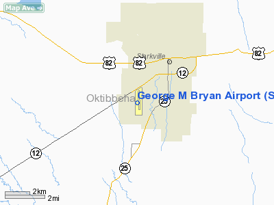
George M. Bryan Airport (ICAO: KSTF, FAA LID: STF) is a city-owned public-use airport located three nautical miles (6 km) southwest of the central business district of Starkville, a city in Oktibbeha County, Mississippi, United States. The airport, also known as George M. Bryan Field, was named in honor of World War II veteran and Starkville native George Martin Bryan.
Although most U.S. airports use the same three-letter location identifier for the FAA and IATA, this airport is assigned STF by the FAA but has no designation from the IATA.
Facilities and aircraft
Bryan Airport covers an area of 635 acres (2.57 km) at an elevation of 333 feet (101 m) above mean sea level. It has one runway designated 18/36 with a 5,550 x 150 ft (1,694 x 46 m) asphalt and concrete surface.
For the 12-month period ending February 14, 2008, the airport had 22,520 aircraft operations, an average of 61 per day: 98% general aviation and 2% military. At that time there were 48 aircraft based at this airport: 69% single-engine, 8% multi-engine, 6% jet, 2% helicopter and 15% glider.
The above content comes from Wikipedia and is published under free licenses – click here to read more.
Location & QuickFacts
| FAA Information Effective: | 2008-09-25 |
| Airport Identifier: | STF |
| Airport Status: | Operational |
| Longitude/Latitude: | 088-50-55.0000W/33-25-59.2000N
-88.848611/33.433111 (Estimated) |
| Elevation: | 333 ft / 101.50 m (Surveyed) |
| Land: | 635 acres |
| From nearest city: | 3 nautical miles SW of Starkville, MS |
| Location: | Oktibbeha County, MS |
| Magnetic Variation: | 01W (2005) |
Owner & Manager
| Ownership: | Publicly owned |
| Owner: | City Of Starkville |
| Address: | 101 Lampkin St
Starkville, MS 39759 |
| Phone number: | 662-323-4583 |
| Manager: | Tom Stennis |
| Address: | 114 Airport Rd.
Starkville, MS 39759 |
| Phone number: | 662-648-9935
662-418-5900 (CELL) |
Airport Operations and Facilities
| Airport Use: | Open to public |
| Wind indicator: | Yes |
| Segmented Circle: | Yes |
| Control Tower: | No |
| Lighting Schedule: | DUSK-DAWN
AFTER 1630 ACTVT HIRL RY 18/36 - CTAF. PAPI RYS 18 & 36 OPER CONTINUOUSLY. |
| Beacon Color: | Clear-Green (lighted land airport) |
| Landing fee charge: | No |
| Sectional chart: | Memphis |
| Region: | ASO - Southern |
| Boundary ARTCC: | ZME - Memphis |
| Tie-in FSS: | GWO - Greenwood |
| FSS on Airport: | No |
| FSS Toll Free: | 1-800-WX-BRIEF |
| NOTAMs Facility: | GWO (NOTAM-d service avaliable) |
| Federal Agreements: | NGRY3 |
Airport Communications
| CTAF: | 122.700 |
| Unicom: | 122.700 |
Airport Services
| Fuel available: | 100LLA |
| Airframe Repair: | MAJOR |
| Power Plant Repair: | MAJOR |
| Bottled Oxygen: | NONE |
| Bulk Oxygen: | NONE |
Runway Information
Runway 18/36
| Dimension: | 5550 x 150 ft / 1691.6 x 45.7 m |
| Surface: | ASPH-CONC, Good Condition |
| Weight Limit: | Single wheel: 25000 lbs.
Dual wheel: 30000 lbs. |
| Edge Lights: | High |
| |
Runway 18 |
Runway 36 |
| Longitude: | 088-50-55.7988W | 088-50-54.1464W |
| Latitude: | 33-26-26.6622N | 33-25-31.7739N |
| Elevation: | 332.00 ft | 321.00 ft |
| Alignment: | 127 | 127 |
| ILS Type: | | LOC/DME |
| Traffic Pattern: | Left | Left |
| Markings: | Non-precision instrument, Good Condition | Non-precision instrument, Good Condition |
| Crossing Height: | 24.00 ft | 26.00 ft |
| Displaced threshold: | 1380.00 ft | 0.00 ft |
| VASI: | 2-light PAPI on left side | 2-light PAPI on left side |
| Visual Glide Angle: | 3.00° | 3.00° |
| Obstruction: | 85 ft trees, 2150.0 ft from runway, 400 ft right of centerline, 22:1 slope to clear
APCH RATIO 40:1 FROM DSPLCD THLD. | , 50:1 slope to clear |
|
Radio Navigation Aids
| ID |
Type |
Name |
Ch |
Freq |
Var |
Dist |
| STF | NDB | Bryan | | 281.00 | 02E | 0.1 nm |
| LMS | NDB | Louisville | | 212.00 | 00E | 20.4 nm |
| AIV | NDB | Aliceville | | 254.00 | | 38.4 nm |
| OSX | NDB | Kosciusko | | 269.00 | 00W | 40.4 nm |
| MPE | NDB | Philadelphia | | 219.00 | 01E | 40.6 nm |
| NJW | TACAN | Joe Williams | 61Y | | 01E | 38.4 nm |
| OTB | VOR/DME | Tupelo | 035X | 109.80 | 04E | 47.6 nm |
| IGB | VORTAC | Bigbee | 109X | 116.20 | 04E | 17.1 nm |
| CBM | VORTAC | Caledonia | 099X | 115.20 | 00E | 24.1 nm |
Remarks
- APPROX 4 BASED MISS STATE UNIV AIRCRAFT USED FOR EXPERIMENTAL PURPOSES.
Images and information placed above are from
http://www.airport-data.com/airport/STF/
We thank them for the data!
| General Info
|
| Country |
United States
|
| State |
MISSISSIPPI
|
| FAA ID |
STF
|
| Latitude |
33-25-59.241N
|
| Longitude |
088-50-54.977W
|
| Elevation |
332 feet
|
| Near City |
STARKVILLE
|
We don't guarantee the information is fresh and accurate. The data may
be wrong or outdated.
For more up-to-date information please refer to other sources.
|
|


