 |
|
| Fletcher Field |
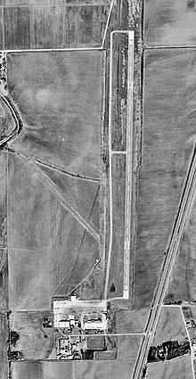 |
| USGS aerial photo - 26 January 1998 |
| IATA: CKM – ICAO: KCKM – FAA LID: CKM |
| Summary |
| Airport type |
Public |
| Owner |
Coahoma County Airport Board |
| Serves |
Clarksdale, Mississippi |
| Location |
Coahoma County, near Clarksdale, Mississippi |
| Elevation AMSL |
173 ft / 53 m |
| Coordinates |
34°17′59″N 090°30′44″W / 34.29972°N 90.51222°W / 34.29972; -90.51222 |
| Runways |
| Direction |
Length |
Surface |
| ft |
m |
| 18/36 |
5,404 |
1,647 |
Asphalt |
| Statistics (2007) |
| Aircraft operations |
29,980 |
| Based aircraft |
11 |
| Source: Federal Aviation Administration |
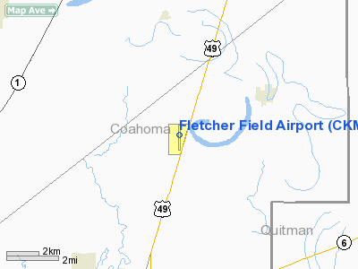
Fletcher Field (IATA: CKM, ICAO: KCKM, FAA LID: CKM) is a county-owned public-use airport located seven nautical miles (13 km) northeast of the central business district of Clarksdale, a city in Coahoma County, Mississippi, United States. The airport serves the general aviation community, with no scheduled commercial airline service. History
Fletcher Field, was opened on 5 July 1942 and used by the United States Army Air Forces as a contract basic flying training airfield. It was operated by the 2154th Air Base Unit, Contract Elementary Flying School (AAFFTC), Clarksdale School of Aviation. Students were trained on Fairchild PT-23 and Boeing-Stearman PT-17 trainers.
It operated until 14 October 1944 when the last class graduated. The equipment and aircraft at the base were declared excess and sold in November. The airfield was then turned over to civil authorities as an airport.
Facilities and aircraft
Fletcher Field covers an area of 252 acres (102 ha) at an elevation of 173 feet (53 m) above mean sea level. It has one asphalt paved runway designated 18/36 which measures 5,404 by 100 feet (1,647 x 30 m).
For the 12-month period ending August 29, 2007, the airport had 29,980 aircraft operations, an average of 82 per day: 99% general aviation and <1% military.vAt that time there were 11 aircraft based at this airport:v73% single-engine, 18% multi-engine and 9% jet.
The above content comes from Wikipedia and is published under free licenses – click here to read more.
Location & QuickFacts
| FAA Information Effective: | 2008-09-25 |
| Airport Identifier: | CKM |
| Airport Status: | Operational |
| Longitude/Latitude: | 090-30-44.3000W/34-17-59.0000N
-90.512306/34.299722 (Estimated) |
| Elevation: | 173 ft / 52.73 m (Surveyed) |
| Land: | 252 acres |
| From nearest city: | 7 nautical miles NE of Clarksdale, MS |
| Location: | Coahoma County, MS |
| Magnetic Variation: | 02E (1990) |
Owner & Manager
| Ownership: | Publicly owned |
| Owner: | Coahoma Co Airport Board
AND CITY OF CLARKSDALE |
| Address: | P.o. Box 820
Clarksdale, MS 38614 |
| Phone number: | 662-624-5448 |
| Manager: | David Huggins |
| Address: | P.o. Box 700
Clarksdale, MS 38614 |
| Phone number: | 662-627-4126 |
Airport Operations and Facilities
| Airport Use: | Open to public |
| Wind indicator: | Yes |
| Segmented Circle: | Yes |
| Control Tower: | No |
| Lighting Schedule: | DUSK-DAWN
ACTVT MIRL RY 18/36, PAPI RYS 18 & 36 AND REIL RYS 18 & 36 - CTAF. |
| Beacon Color: | Clear-Green (lighted land airport) |
| Landing fee charge: | No |
| Sectional chart: | Memphis |
| Region: | ASO - Southern |
| Boundary ARTCC: | ZME - Memphis |
| Tie-in FSS: | GWO - Greenwood |
| FSS on Airport: | No |
| FSS Toll Free: | 1-800-WX-BRIEF |
| NOTAMs Facility: | GWO (NOTAM-d service avaliable) |
| Federal Agreements: | NGPY |
Airport Communications
| CTAF: | 122.800 |
| Unicom: | 122.800 |
Airport Services
| Fuel available: | 100LLA |
| Bottled Oxygen: | NONE |
| Bulk Oxygen: | NONE |
Runway Information
Runway 18/36
| Dimension: | 5404 x 100 ft / 1647.1 x 30.5 m |
| Surface: | ASPH, Good Condition |
| Weight Limit: | Single wheel: 25000 lbs.
Dual wheel: 32000 lbs. |
| Edge Lights: | Medium |
| |
Runway 18 |
Runway 36 |
| Longitude: | 090-30-42.8709W | 090-30-45.8090W |
| Latitude: | 34-18-25.6489N | 34-17-32.2456N |
| Elevation: | 172.00 ft | 172.00 ft |
| Alignment: | 127 | 3 |
| Traffic Pattern: | Left | Left |
| Markings: | Non-precision instrument, Good Condition | Non-precision instrument, Good Condition |
| Crossing Height: | 27.00 ft | 27.00 ft |
| VASI: | 2-light PAPI on left side | 2-light PAPI on left side |
| Visual Glide Angle: | 3.00° | 3.00° |
| Runway End Identifier: | Yes
REIL RY 18 OTS INDEFLY. | Yes
REIL RY 36 OTS INDEFLY. |
| Obstruction: | , 50:1 slope to clear | 89 ft trees, 2240.0 ft from runway, 22:1 slope to clear |
|
Radio Navigation Aids
| ID |
Type |
Name |
Ch |
Freq |
Var |
Dist |
| CKM | NDB | Clarksdale | | 341.00 | 02E | 0.4 nm |
| HEE | NDB | Thompson-robbins | | 251.00 | 01E | 18.2 nm |
| RNV | NDB | Renova | | 272.00 | 04E | 32.1 nm |
| SBQ | NDB | Scobey | | 245.00 | 01E | 40.1 nm |
| FCY | NDB | Forrest City | | 332.00 | 01E | 40.7 nm |
| BKZ | NDB | Brinkley | | 242.00 | 02E | 48.0 nm |
| IDL | NDB | Indianola | | 284.00 | 03E | 49.9 nm |
| UJM | VOR/DME | Marvell | 033X | 109.60 | 01E | 18.4 nm |
Remarks
- NUMEROUS AGRICULTURAL ACFT OPR WEST OF N/S TWY. ACFT DEP N; LND S.
- 24 HR SELF SERVICE WITH CREDIT CARD ON 100LL.
- EXISTED PRIOR TO 1959.
Images and information placed above are from
http://www.airport-data.com/airport/CKM/
We thank them for the data!
| General Info
|
| Country |
United States
|
| State |
MISSISSIPPI
|
| FAA ID |
CKM
|
| Latitude |
34-17-58.956N
|
| Longitude |
090-30-44.338W
|
| Elevation |
173 feet
|
| Near City |
CLARKSDALE
|
We don't guarantee the information is fresh and accurate. The data may
be wrong or outdated.
For more up-to-date information please refer to other sources.
|
|


