 |
|
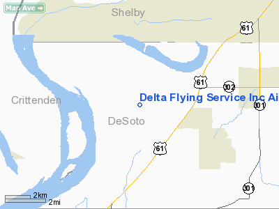
Delta Flying Service Inc Airport |
Location & QuickFacts
| FAA Information Effective: | 2008-09-25 |
| Airport Identifier: | MS65 |
| Airport Status: | Operational |
| Longitude/Latitude: | 090-12-00.3410W/34-57-00.3440N
-90.200095/34.950096 (Estimated) |
| Elevation: | 210 ft / 64.01 m (Estimated) |
| Land: | 0 acres |
| From nearest city: | 3 nautical miles SW of Walls, MS |
| Location: | De Soto County, MS |
| Magnetic Variation: | 02E (1985) |
Owner & Manager
| Ownership: | Privately owned |
| Owner: | Delta Dusters |
| Address: | P.o. Box 365
Walls, MS 38680 |
| Phone number: | 601-781-2501 |
| Manager: | Delta Dusters |
| Address: | P.o. Box 297
Walls, MS 38680 |
| Phone number: | 601-781-2623 |
Airport Operations and Facilities
| Airport Use: | Private |
| Wind indicator: | Yes |
| Segmented Circle: | No |
| Control Tower: | No |
| Landing fee charge: | No |
| Sectional chart: | Memphis |
| Region: | ASO - Southern |
| Traffic Pattern Alt: | 600 ft |
| Boundary ARTCC: | ZME - Memphis |
| Tie-in FSS: | GWO - Greenwood |
| FSS on Airport: | No |
| FSS Toll Free: | 1-800-WX-BRIEF |
Airport Services
| Airframe Repair: | MAJOR |
| Power Plant Repair: | MAJOR |
Runway Information
Runway 18/36
| Dimension: | 2600 x 100 ft / 792.5 x 30.5 m |
| Surface: | TURF, |
| |
Runway 18 |
Runway 36 |
| Traffic Pattern: | Right | Left |
|
Radio Navigation Aids
| ID |
Type |
Name |
Ch |
Freq |
Var |
Dist |
| ME | NDB | Elvis | | 287.00 | 01E | 9.2 nm |
| AWM | NDB | West Memphis | | 362.00 | 01E | 11.5 nm |
| SPQ | NDB | Spain | | 414.00 | 04E | 16.8 nm |
| OLV | NDB | Olive Branch | | 275.00 | 01E | 20.3 nm |
| MIG | NDB | Millington | | 232.00 | 04E | 23.7 nm |
| FCY | NDB | Forrest City | | 332.00 | 01E | 28.3 nm |
| HEE | NDB | Thompson-robbins | | 251.00 | 01E | 32.7 nm |
| CKM | NDB | Clarksdale | | 341.00 | 02E | 42.5 nm |
| FYE | NDB | Somerville | | 255.00 | 00E | 42.6 nm |
| BPW | NDB | Osceola | | 239.00 | 02E | 45.6 nm |
| BKZ | NDB | Brinkley | | 242.00 | 02E | 48.4 nm |
| COO | NDB | Covington | | 326.00 | 02E | 48.8 nm |
| GQE | VOR/DME | Gilmore | 077X | 113.00 | 04E | 27.5 nm |
| UJM | VOR/DME | Marvell | 033X | 109.60 | 01E | 32.5 nm |
| MEM | VORTAC | Memphis | 122X | 117.50 | 01E | 11.4 nm |
| HLI | VORTAC | Holly Springs | 071X | 112.40 | 03E | 36.3 nm |
| MEM | VOT | Memphis Metropolitn | | 111.00 | | 12.4 nm |
Remarks
- VFR OPERATIONS/PRIVATE USE. TFC PAT WEST SIDE OF ARPT AT AN ALT BELOW THE EXISTING TFC PAT ALT AT TWINKLE TOWN ARPT & ALL OPERATIONS CONDUCTED WEST OF RWY CENTERLINE EXTENDED.
Images and information placed above are from
http://www.airport-data.com/airport/MS65/
We thank them for the data!
| General Info
|
| Country |
United States
|
| State |
MISSISSIPPI
|
| FAA ID |
MS65
|
| Latitude |
34-57-00.344N
|
| Longitude |
090-12-00.341W
|
| Elevation |
210 feet
|
| Near City |
WALLS
|
We don't guarantee the information is fresh and accurate. The data may
be wrong or outdated.
For more up-to-date information please refer to other sources.
|
|


