 |
|
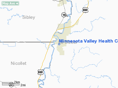
Minnesota Valley Health Center Heliport |
Location & QuickFacts
| FAA Information Effective: | 2008-09-25 |
| Airport Identifier: | MY26 |
| Airport Status: | Operational |
| Longitude/Latitude: | 093-54-56.3704W/44-27-11.7727N
-93.915658/44.453270 (Estimated) |
| Elevation: | 839 ft / 255.73 m (Estimated) |
| Land: | 0 acres |
| From nearest city: | 1 nautical miles SE of Le Sueur, MN |
| Location: | Le Sueur County, MN |
| Magnetic Variation: | 02E (2000) |
Owner & Manager
| Ownership: | Privately owned |
| Owner: | City Of Le Sueur |
| Address: | 203 South Second St.
Le Sueur, MN 56058 |
| Phone number: | 507-665-6401 |
| Manager: | Richard Almich, City Administrator |
| Address: | 203 South Second St.
Le Sueur, MN 56058 |
| Phone number: | 507-665-6401 |
Airport Operations and Facilities
| Airport Use: | Private |
| Wind indicator: | Yes |
| Segmented Circle: | No |
| Control Tower: | No |
| Lighting Schedule: | DUSK-DAWN |
| Sectional chart: | Omaha |
| Region: | AGL - Great Lakes |
| Boundary ARTCC: | ZMP - Minneapolis |
| Tie-in FSS: | PNM - Princeton |
| FSS Toll Free: | 1-800-WX-BRIEF |
Runway Information
Helipad H1
| Dimension: | 50 x 50 ft / 15.2 x 15.2 m |
| Surface: | CONC, |
| |
Runway H1 |
Runway |
| Traffic Pattern: | Left | Left |
|
Radio Navigation Aids
| ID |
Type |
Name |
Ch |
Freq |
Var |
Dist |
| GYL | NDB | Glencoe | | 407.00 | 03E | 19.9 nm |
| ACQ | NDB | Waseca | | 371.00 | 02E | 27.8 nm |
| HCD | NDB | Hutchinson | | 209.00 | 04E | 31.4 nm |
| JYG | NDB | St James | | 260.00 | 04E | 39.3 nm |
| MS | NDB | Narco | | 266.00 | 02E | 41.8 nm |
| PPI | NDB | Hopey | | 400.00 | 03E | 48.7 nm |
| ULM | NDB/DME | New Ulm | 050X | 272.00 | 04E | 26.3 nm |
| MKT | VOR/DME | Mankato | 045X | 110.80 | 07E | 14.0 nm |
| FOW | VOR/DME | Halfway | 049X | 111.20 | 02E | 27.8 nm |
| FCM | VOR/DME | Flying Cloud | 055X | 111.80 | 06E | 29.8 nm |
| MSP | VOR/DME | Minneapolis | 100X | 115.30 | 02E | 39.4 nm |
| FGT | VORTAC | Farmington | 104X | 115.70 | 06E | 33.2 nm |
| DWN | VORTAC | Darwin | 027X | 109.00 | 07E | 44.5 nm |
| GEP | VORTAC | Gopher | 120X | 117.30 | 06E | 47.6 nm |
| MSP | VOT | Minneapolis St Paul | | 111.00 | | 39.6 nm |
| STP | VOT | St Paul | | 114.40 | | 46.9 nm |
Remarks
- PRVDD ALL APCH/DEP FROM 075 TO 195 DEG AND FROM 260 TO 320 DEG; AREA IS MARKED AND LIGHTED FOR NIGHT OPNS.
Images and information placed above are from
http://www.airport-data.com/airport/MY26/
We thank them for the data!
We don't guarantee the information is fresh and accurate. The data may
be wrong or outdated.
For more up-to-date information please refer to other sources.
|
|


