 |
|
| Yale Airport |
| IATA: none – ICAO: none – FAA LID: D20 |
| Summary |
| Airport type |
Public |
| Owner/Operator |
Jerry L. Norris |
| Location |
Yale, Michigan |
| Elevation AMSL |
814 ft / 248 m |
| Coordinates |
43°06′45″N 82°47′15″W / 43.1125261°N 82.7874294°W / 43.1125261; -82.7874294Coordinates: 43°06′45″N 82°47′15″W / 43.1125261°N 82.7874294°W / 43.1125261; -82.7874294 |
| Runways |
| Direction |
Length |
Surface |
| ft |
m |
| 09/27 |
2,300 |
701 |
Turf |
| Source: Federal Aviation Administration |
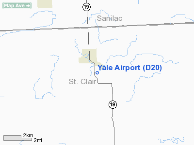
Yale Airport (FAA LID: D20) is a general aviation airport located 1 mile (1.6 km) southeast of Yale in St Clair County, Michigan, USA.
The above content comes from Wikipedia and is published under free licenses – click here to read more.
Location & QuickFacts
| FAA Information Effective: | 2008-09-25 |
| Airport Identifier: | D20 |
| Airport Status: | Operational |
| Longitude/Latitude: | 082-47-14.7460W/43-06-45.0940N
-82.787429/43.112526 (Estimated) |
| Elevation: | 814 ft / 248.11 m (Estimated) |
| Land: | 15 acres |
| From nearest city: | 1 nautical miles SE of Yale, MI |
| Location: | St Clair County, MI |
| Magnetic Variation: | 06W (1985) |
Owner & Manager
| Ownership: | Privately owned |
| Owner: | Jerry L. Norris |
| Address: | 7387 Brockway Rd
Yale, MI 48097 |
| Phone number: | 810-387-2173 |
| Manager: | Jerry L. Norris |
| Address: | 7387 Brockway Rd
Yale, MI 48097 |
| Phone number: | 810-387-2173 |
Airport Operations and Facilities
| Airport Use: | Open to public |
| Wind indicator: | Yes |
| Segmented Circle: | Yes |
| Control Tower: | No |
| Landing fee charge: | No |
| Sectional chart: | Detroit |
| Region: | AGL - Great Lakes |
| Boundary ARTCC: | ZOB - Cleveland |
| Tie-in FSS: | LAN - Lansing |
| FSS on Airport: | No |
| FSS Toll Free: | 1-800-WX-BRIEF |
| NOTAMs Facility: | LAN (NOTAM-d service avaliable) |
Airport Communications
Airport Services
| Airframe Repair: | NONE |
| Bottled Oxygen: | NONE |
| Bulk Oxygen: | NONE |
Runway Information
Runway 09/27
| Dimension: | 2300 x 110 ft / 701.0 x 33.5 m |
| Surface: | TURF, Fair Condition |
| Edge Lights: | Non-standard lighting system
NSTD LIRL - NON-STANDARD COLOR & CONFIGURATION. RY LIGHTED ON S SIDE ONLY WITH NON-STANDARD COLOR; NOT FOR PUBLIC USE. |
| |
Runway 09 |
Runway 27 |
| Longitude: | 082-47-30.2400W | 082-46-59.2300W |
| Latitude: | 43-06-45.0800N | 43-06-45.0800N |
| Elevation: | 814.00 ft | 814.00 ft |
| Traffic Pattern: | Left | Left |
| Displaced threshold: | 315.00 ft | 300.00 ft |
| Runway End Identifier: | No | No |
| Centerline Lights: | No | No |
| Touchdown Lights: | No | No |
| Obstruction: | 15 ft road, 42.0 ft from runway, 2:1 slope to clear
APCH RATIO 25:1 AT DSPLCD THLD, +25 FT POWERLINE 633 FT DSTC. | 6 ft brush, 25.0 ft from runway, 4:1 slope to clear
APCH RATIO 20:1 AT DSPLCD THLD. 73 FT TREES 1510 FT DSTC. |
|
Radio Navigation Aids
| ID |
Type |
Name |
Ch |
Freq |
Var |
Dist |
| ZR | NDB | Sarnia | | 404.00 | 06W | 26.4 nm |
| VQ | NDB | Cargl | | 230.00 | 05W | 46.1 nm |
| QG | NDB | Windsor | | 353.00 | 06W | 48.2 nm |
| MTC | TACAN | Selfridge | 064X | | 06W | 30.1 nm |
| BAX | VOR/DME | Bad Axe | 019X | 108.20 | 05W | 41.2 nm |
| ECK | VORTAC | Peck | 087X | 114.00 | 07W | 9.1 nm |
| PSI | VORTAC | Pontiac | 047X | 111.00 | 03W | 41.1 nm |
| FNT | VORTAC | Flint | 116X | 116.90 | 06W | 43.1 nm |
| DET | VOT | Detroit City | | 111.60 | | 43.7 nm |
Remarks
- RY 09 HAS +25 FT PLINE 345 FT DIST.
- RY 09/27 SOFT IN SPRING.
- ESTABD PRIOR TO 1959.
Images and information placed above are from
http://www.airport-data.com/airport/D20/
We thank them for the data!
| General Info
|
| Country |
United States
|
| State |
MICHIGAN
|
| FAA ID |
D20
|
| Latitude |
43-06-45.094N
|
| Longitude |
082-47-14.746W
|
| Elevation |
814 feet
|
| Near City |
YALE
|
We don't guarantee the information is fresh and accurate. The data may
be wrong or outdated.
For more up-to-date information please refer to other sources.
|
|


