 |
|
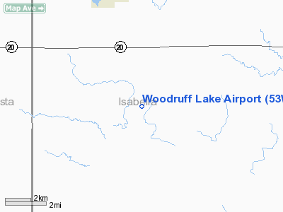
Location & QuickFacts
| FAA Information Effective: | 2008-09-25 |
| Airport Identifier: | 53W |
| Airport Status: | Operational |
| Longitude/Latitude: | 084-58-42.8000W/43-33-16.1000N
-84.978556/43.554472 (Estimated) |
| Elevation: | 940 ft / 286.51 m (Estimated) |
| Land: | 30 acres |
| From nearest city: | 4 nautical miles NW of Winn, MI |
| Location: | Isabella County, MI |
| Magnetic Variation: | 04W (1985) |
Owner & Manager
| Ownership: | Privately owned |
| Owner: | William J. Hill |
| Address: | 5833 South Lakeshore Dr
Remus, MI 49340 |
| Phone number: | 989-561-5123 |
| Manager: | William J. Hill |
| Address: | 5833 South Lakeshore Dr
Remus, MI 49340 |
| Phone number: | 989-561-5123 |
Airport Operations and Facilities
| Airport Use: | Open to public |
| Wind indicator: | Yes |
| Segmented Circle: | No |
| Control Tower: | No |
| Sectional chart: | Detroit |
| Region: | AGL - Great Lakes |
| Boundary ARTCC: | ZMP - Minneapolis |
| Tie-in FSS: | LAN - Lansing |
| FSS on Airport: | No |
| FSS Toll Free: | 1-800-WX-BRIEF |
| NOTAMs Facility: | LAN (NOTAM-d service avaliable) |
Airport Communications
Airport Services
Runway Information
Runway 09/27
| Dimension: | 3700 x 105 ft / 1127.8 x 32.0 m |
| Surface: | TURF, Good Condition |
| |
Runway 09 |
Runway 27 |
| Longitude: | 084-59-07.9700W | 084-58-17.7200W |
| Latitude: | 43-33-16.2100N | 43-33-16.0500N |
| Traffic Pattern: | Left | Left |
| Displaced threshold: | 341.00 ft | 260.00 ft |
| Obstruction: | 17 ft road, 137.0 ft from runway, 8:1 slope to clear
APCH RATIO 10:1 AT DSPLCD THLD BASED ON 34 FT TREE, 335 FT FM THLD 125 FT R. | 15 ft road, 68.0 ft from runway, 4:1 slope to clear
RWY 27 APCH RATIO 21:1 AT DSPLCD THLD BASED ON 15 FT ROAD, 328 FT DSTC, 0B. |
|
Radio Navigation Aids
| ID |
Type |
Name |
Ch |
Freq |
Var |
Dist |
| AMN | NDB | Alma | | 329.00 | 05W | 16.3 nm |
| GDW | NDB | Wiggins | | 209.00 | 04W | 33.2 nm |
| CAD | NDB | Cadillac | | 269.00 | 04W | 47.2 nm |
| HYX | NDB | Browne | | 385.00 | 06W | 49.4 nm |
| MOP | VOR/DME | Mount Pleasant | 043X | 110.60 | 05W | 11.3 nm |
| HIC | VOR/DME | White Cloud | 123X | 117.60 | 01W | 32.1 nm |
| MBS | VOR/DME | Saginaw | 076X | 112.90 | 03W | 39.3 nm |
Remarks
- PROVIDING OBSTRUCTIONS IN RY APCH SFCS BE LOWERED/REMOVED TO PROVIDE MINIMUM 20:1 APCH CLNC; OR THRS DSPLCD & MKD TO PROVIDE MINIMUM 20:1 APCH CLNC OVER ALL OBSTRUCTIONS.
Images and information placed above are from
http://www.airport-data.com/airport/53W/
We thank them for the data!
| General Info
|
| Country |
United States
|
| State |
MICHIGAN
|
| FAA ID |
53W
|
| Latitude |
43-33-16.107N
|
| Longitude |
084-58-44.080W
|
| Elevation |
940 feet
|
| Near City |
WINN
|
We don't guarantee the information is fresh and accurate. The data may
be wrong or outdated.
For more up-to-date information please refer to other sources.
|
|


