 |
|
| Willow Run Airport (YIP) |
| IATA: YIP – ICAO: KYIP |
| Summary |
| Airport type |
Public |
| Operator |
Wayne County Airport Authority |
| Location |
Van Buren Charter Township and Ypsilanti Township |
| Elevation AMSL |
716 ft / 218 m |
| Coordinates |
42°14′16.539″N 83°31′49.472″W / 42.2379275°N 83.53040889°W / 42.2379275; -83.53040889Coordinates: 42°14′16.539″N 83°31′49.472″W / 42.2379275°N 83.53040889°W / 42.2379275; -83.53040889 |
| Runways |
| Direction |
Length |
Surface |
| ft |
m |
| 5L/23R |
6,653 |
2,028 |
Paved |
| 5R/23L |
7,526 |
2,294 |
Paved |
| 9/27 |
7,293 |
2,223 |
Paved |
| 14/32 |
6,912 |
2,107 |
Paved |
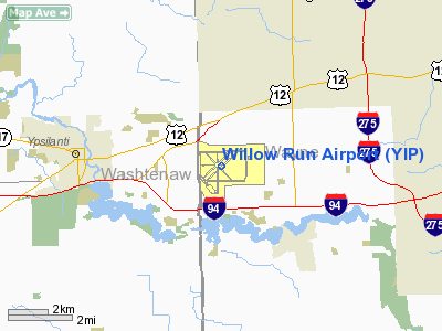
Willow Run Airport (IATA: YIP, ICAO: KYIP) is an airport located in Van Buren Charter Township and in Ypsilanti Township, near Ypsilanti, Michigan, that serves freight, corporate, and general aviation clients. No commercial passenger services are available at the airport. The airport has four runways (the fifth runway, 9R/27L, was recently closed and redesginated taxiway H), a continuously staffed FAA control tower, and US Customs operations. Willow Run Airport is one of two facilities operated by Wayne County Airport Authority, the other being Detroit Metropolitan Wayne County Airport, which replaced Willow Run as the major commercial airport for the region in the late 1960s. Major worldwide cargo airlines Kalitta Air and National Airlines are based at Willow Run Airport. History
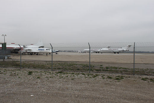 | |
Planes on Tarmac- Hangar 1 |
Willow Run Airport was built during World War II along with the Willow Run plant, where the Ford Motor Company produced
B-24 bombers for the US Government. Bomber production ceased at the plant after the war, and it was converted into a passenger terminal. Commercial passenger traffic was moved from Detroit City Airport, making Willow Run Detroit's primary airport.
In 1946 Warren Avis founded Avis Airlines Rent a Car Systems at Willow Run Airport. It was the first rental car operation at an airport location.
The Federal Government sold the airport to the University of Michigan in 1947 for $1.00. Terms of the sale required that the university operate the airport as a research facility, and the Michigan Aeronautical Research Center (later renamed Willow Run Research Center) was founded. For a time, the university housed part of its student population in the apartments previously used by plant workers.
In 1956, there were seven commercial passenger carriers operating out of Willow Run. Commercial service began to shift to the nearby Detroit Metro Airport during the late 1950s, and by 1967 it had ceased altogether.
In 1977, the University of Michigan sold the airport to Wayne County for $1.00.
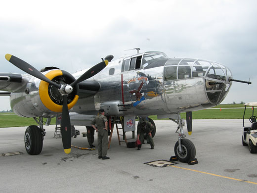 | |
Yankee Warrior, a fully operational B-25 Mitchell, is operated by the Yankee Air Museum. |
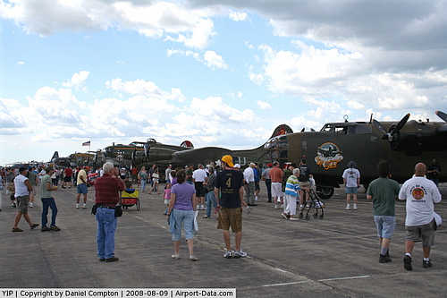
The Yankee Air Museum opened on the airport grounds in 1981. A fire in October 2004 destroyed the museums building and most of its artifacts. The static display aircraft like the B-52 and other aircraft that were too large to be on display inside the hangar were undamaged. In 2005 the museum moved to the other side of the airport where they are rebuilding their displays and gathering more WWII memorabilia.
The above content comes from Wikipedia and is published under free licenses – click here to read more.
|
 |
(Click on the photo to enlarge) |
|
 |
(Click on the photo to enlarge) |
|
 |
(Click on the photo to enlarge) |
|
 |
(Click on the photo to enlarge) |
Location & QuickFacts
| FAA Information Effective: | 2008-09-25 |
| Airport Identifier: | YIP |
| Airport Status: | Operational |
| Longitude/Latitude: | 083-31-48.3000W/42-14-15.8000N
-83.530083/42.237722 (Estimated) |
| Elevation: | 716 ft / 218.24 m (Surveyed) |
| Land: | 2600 acres |
| From nearest city: | 24 nautical miles SW of Detroit, MI |
| Location: | Wayne County, MI |
| Magnetic Variation: | 06W (1995) |
Owner & Manager
| Ownership: | Publicly owned |
| Owner: | Wayne County Airport Authority |
| Address: | L C Smith - Terminal Mezzanine
Detroit, MI 48242 |
| Phone number: | 734-485-6666 |
| Manager: | David Dimaria |
| Address: | 801 Willow Run Airport
Ypsilanti, MI 48198 |
| Phone number: | 734-485-6670 |
Airport Operations and Facilities
| Airport Use: | Open to public |
| Wind indicator: | Yes |
| Segmented Circle: | No |
| Control Tower: | Yes |
| Lighting Schedule: | DUSK-DAWN |
| Beacon Color: | Clear-Green (lighted land airport) |
| Landing fee charge: | Yes
LANDING FEE IS BASED ON ACFT GWT. |
| Sectional chart: | Detroit |
| Region: | AGL - Great Lakes |
| Boundary ARTCC: | ZOB - Cleveland |
| Tie-in FSS: | LAN - Lansing |
| FSS on Airport: | No |
| FSS Toll Free: | 1-800-WX-BRIEF |
| NOTAMs Facility: | YIP (NOTAM-d service avaliable) |
| Certification type/date: | IV A U 10/197
ARFF INDEX E SVC AVBL ON REQUEST CALL 734-485-6660. |
| Federal Agreements: | NGPRXY |
Airport Services
| Fuel available: | 100LLA |
| Airframe Repair: | MAJOR |
| Power Plant Repair: | MAJOR |
| Bottled Oxygen: | HIGH |
| Bulk Oxygen: | HIGH |
Runway Information
Runway 05L/23R
| Dimension: | 5995 x 160 ft / 1827.3 x 48.8 m |
| Surface: | ASPH, Fair Condition |
| Surface Treatment: | Saw-cut or plastic Grooved
ONLY THE 80' CENTER PORTION OF THE RY IS GRVD.
ONLY THE 80' CENTER PORTION OF THE RY IS GRVD. |
| Weight Limit: | Single wheel: 35000 lbs.
Dual wheel: 45000 lbs.
Dual tandem wheel: 90000 lbs. |
| Edge Lights: | Medium |
| |
Runway 05L |
Runway 23R |
| Longitude: | 083-32-30.0638W | 083-31-32.0342W |
| Latitude: | 42-13-55.8674N | 42-14-36.4676N |
| Elevation: | 715.00 ft | 707.00 ft |
| Alignment: | 47 | 127 |
| Traffic Pattern: | Left | Left |
| Markings: | Non-precision instrument, Fair Condition | Non-precision instrument, Fair Condition |
| Runway End Identifier: | No | No |
| Centerline Lights: | No | No |
| Touchdown Lights: | No | No |
| Obstruction: | 65 ft trees, 1175.0 ft from runway, 284 ft left of centerline, 15:1 slope to clear | 56 ft trees, 1619.0 ft from runway, 288 ft right of centerline, 25:1 slope to clear |
|
Runway 05R/23L
| Dimension: | 7526 x 150 ft / 2293.9 x 45.7 m |
| Surface: | ASPH, Fair Condition |
| Weight Limit: | Single wheel: 55000 lbs.
Dual wheel: 70000 lbs.
Dual tandem wheel: 120000 lbs. |
| Edge Lights: | High |
| |
Runway 05R |
Runway 23L |
| Longitude: | 083-32-23.4690W | 083-31-10.6450W |
| Latitude: | 42-13-50.2450N | 42-14-41.2240N |
| Elevation: | 715.00 ft | 702.00 ft |
| Alignment: | 47 | 127 |
| ILS Type: | ILS/DME
| ILS/DME
|
| Traffic Pattern: | Left | Left |
| Markings: | Precision instrument, Fair Condition | Precision instrument, Fair Condition |
| Crossing Height: | 0.00 ft | 56.00 ft |
| VASI: | | 4-box on left side |
| Visual Glide Angle: | 0.00° | 3.00° |
| RVR Equipment: | touchdown | |
| Approach lights: | MALSR | MALSR |
| Runway End Identifier: | No | No |
| Centerline Lights: | No | No |
| Touchdown Lights: | No | No |
| Obstruction: | 66 ft tree, 2456.0 ft from runway, 719 ft right of centerline, 34:1 slope to clear | , 50:1 slope to clear |
|
Runway 09L/27R
| Dimension: | 7294 x 160 ft / 2223.2 x 48.8 m |
| Surface: | ASPH, Fair Condition |
| Surface Treatment: | Saw-cut or plastic Grooved
ONLY THE 80' CENTER PORTION OF THE RY IS GRVD.
ONLY THE 80' CENTER PORTION OF THE RY IS GRVD. |
| Weight Limit: | Single wheel: 55000 lbs.
Dual wheel: 70000 lbs.
Dual tandem wheel: 120000 lbs. |
| Edge Lights: | Medium |
| |
Runway 09L |
Runway 27R |
| Longitude: | 083-32-35.9640W | 083-30-59.0290W |
| Latitude: | 42-14-38.2420N | 42-14-40.0540N |
| Elevation: | 716.00 ft | 700.00 ft |
| Alignment: | 89 | 127 |
| Traffic Pattern: | Left | Left |
| Markings: | Non-precision instrument, Fair Condition | Non-precision instrument, Fair Condition |
| Displaced threshold: | 574.00 ft | 0.00 ft |
| Runway End Identifier: | No | No |
| Centerline Lights: | No | No |
| Touchdown Lights: | No | No |
| Obstruction: | 25 ft rr, 564.0 ft from runway, 298 ft right of centerline, 14:1 slope to clear | , 50:1 slope to clear |
|
Runway 09R/27L
| Dimension: | 6511 x 160 ft / 1984.6 x 48.8 m |
| Surface: | ASPH, Fair Condition |
| Surface Treatment: | Saw-cut or plastic Grooved
ONLY THE 80' CENTER PORTION OF THE RY IS GRVD.
ONLY THE 80' CENTER PORTION OF THE RY IS GRVD. |
| Weight Limit: | Single wheel: 35000 lbs.
Dual wheel: 45000 lbs.
Dual tandem wheel: 90000 lbs. |
| Edge Lights: | Medium |
| |
Runway 09R |
Runway 27L |
| Longitude: | 083-32-23.3550W | 083-30-56.8450W |
| Latitude: | 42-13-50.7770N | 42-13-52.3790N |
| Elevation: | 715.00 ft | 703.00 ft |
| Alignment: | 89 | 127 |
| Traffic Pattern: | Left | Left |
| Markings: | Non-precision instrument, Fair Condition | Non-precision instrument, Good Condition |
| Crossing Height: | 0.00 ft | 52.00 ft |
| VASI: | | 4-box on left side |
| Visual Glide Angle: | 0.00° | 3.00° |
| Runway End Identifier: | | Yes |
| Centerline Lights: | No | No |
| Touchdown Lights: | No | No |
| Obstruction: | 67 ft trees, 1555.0 ft from runway, 46 ft right of centerline, 20:1 slope to clear | 77 ft tree, 2597.0 ft from runway, 600 ft right of centerline, 31:1 slope to clear |
|
Runway 14/32
| Dimension: | 6312 x 160 ft / 1923.9 x 48.8 m |
| Surface: | ASPH, Fair Condition |
| Surface Treatment: | Saw-cut or plastic Grooved
ONLY THE 80' CENTER PORTION OF THE RY IS GRVD.
ONLY THE 80' CENTER PORTION OF THE RY IS GRVD. |
| Weight Limit: | Single wheel: 35000 lbs.
Dual wheel: 45000 lbs.
Dual tandem wheel: 90000 lbs. |
| Edge Lights: | Medium |
| |
Runway 14 |
Runway 32 |
| Longitude: | 083-32-21.3701W | 083-31-23.1240W |
| Latitude: | 42-14-35.4578N | 42-13-50.5750N |
| Elevation: | 714.00 ft | 704.00 ft |
| Alignment: | 127 | 127 |
| Traffic Pattern: | Left | Left |
| Markings: | Basic, Fair Condition | Basic, Fair Condition |
| Crossing Height: | 0.00 ft | 45.00 ft |
| Displaced threshold: | 0.00 ft | 525.00 ft |
| VASI: | | 4-light PAPI on left side |
| Visual Glide Angle: | 0.00° | 3.50° |
| Runway End Identifier: | No | Yes |
| Centerline Lights: | No | No |
| Touchdown Lights: | No | No |
| Obstruction: | 70 ft ant, 1100.0 ft from runway, 125 ft left of centerline, 15:1 slope to clear | 35 ft gnd, 1454.0 ft from runway, 301 ft left of centerline, 35:1 slope to clear |
|
Radio Navigation Aids
| ID |
Type |
Name |
Ch |
Freq |
Var |
Dist |
| RYS | NDB | Grosse Ile | | 419.00 | 06W | 18.7 nm |
| TCU | NDB | Tecumseh | | 239.00 | 04W | 19.8 nm |
| G | NDB | Golf | | 398.00 | 05W | 21.5 nm |
| VQ | NDB | Cargl | | 230.00 | 05W | 26.6 nm |
| QG | NDB | Windsor | | 353.00 | 06W | 29.8 nm |
| OZW | NDB | Howell | | 243.00 | 05W | 31.3 nm |
| ADG | NDB | Adrian | | 278.00 | 06W | 32.9 nm |
| USE | NDB | Fulton | | 375.00 | 05W | 46.4 nm |
| PT | NDB | Pelee Island | | 283.00 | 05W | 47.3 nm |
| MTC | TACAN | Selfridge | 064X | | 06W | 38.3 nm |
| TOL | TACAN | Toledo | 072X | | 05W | 40.5 nm |
| DXO | VOR/DME | Detroit | 081X | 113.40 | 06W | 7.4 nm |
| YQG | VOR/DME | Windsor | 085X | 113.80 | 06W | 31.2 nm |
| JXN | VOR/DME | Jackson | 033X | 109.60 | 05W | 41.3 nm |
| VWV | VOR/DME | Waterville | 078X | 113.10 | 02W | 47.5 nm |
| SVM | VORTAC | Salem | 090X | 114.30 | 03W | 10.7 nm |
| CRL | VORTAC | Carleton | 104X | 115.70 | 03W | 11.9 nm |
| PSI | VORTAC | Pontiac | 047X | 111.00 | 03W | 27.8 nm |
| FNT | VORTAC | Flint | 116X | 116.90 | 06W | 44.9 nm |
| YIP | VOT | Willow Run | | 112.00 | | 0.4 nm |
| DTW | VOT | Detroit Met Wayne | | 109.80 | | 7.4 nm |
| DET | VOT | Detroit City | | 111.60 | | 25.0 nm |
Remarks
- BIRDS ON & INVOF ARPT.
- 48 HRS PPR FOR UNSKED ACR OPNS WITH MORE THAN 30 PSGR SEATS CALL AMGR 734-485-6670.
- LRA ARPT; ADCUS 734-942-9000.
- CUSTOMS AVBL 24 HRS, MON - FRI AND ON CALL FROM DTW ON WKEND.
Images and information placed above are from
http://www.airport-data.com/airport/YIP/
We thank them for the data!
| General Info
|
| Country |
United States
|
| State |
MICHIGAN
|
| FAA ID |
YIP
|
| Latitude |
42-14-16.539N
|
| Longitude |
083-31-49.472W
|
| Elevation |
716 feet
|
| Near City |
DETROIT
|
We don't guarantee the information is fresh and accurate. The data may
be wrong or outdated.
For more up-to-date information please refer to other sources.
|
|


