 |
|
|
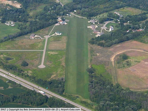 |
(Click on the photo to enlarge) |
|
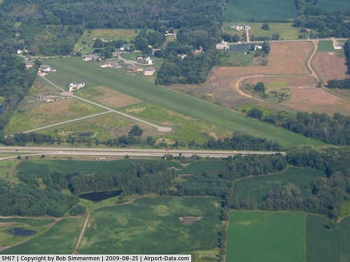 |
(Click on the photo to enlarge) |
Location & QuickFacts
| FAA Information Effective: | 2008-09-25 |
| Airport Identifier: | 5MI7 |
| Airport Status: | Operational |
| Longitude/Latitude: | 084-25-29.3500W/42-21-39.8500N
-84.424819/42.361069 (Estimated) |
| Elevation: | 960 ft / 292.61 m (Estimated) |
| Land: | 20 acres |
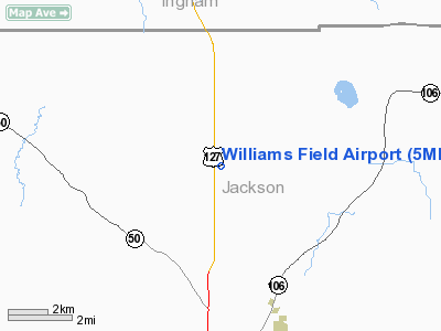
| From nearest city: | 7 nautical miles NE of Jackson, MI |
| Location: | Jackson County, MI |
| Magnetic Variation: | 04W (1985) |
Owner & Manager
| Ownership: | Privately owned |
| Owner: | Densel Williams |
| Address: | 100 Densel Ct
Jackson, MI 49201 |
| Phone number: | 517-569-3609
517-569-2955. |
| Address: |
|
Airport Operations and Facilities
| Airport Use: | Private |
| Wind indicator: | Yes |
| Segmented Circle: | No |
| Control Tower: | No |
| Sectional chart: | Detroit |
| Region: | AGL - Great Lakes |
| Boundary ARTCC: | ZOB - Cleveland |
| Tie-in FSS: | LAN - Lansing |
| FSS Toll Free: | 1-800-WX-BRIEF |
Runway Information
Runway 05/23
| Dimension: | 3000 x 100 ft / 914.4 x 30.5 m |
| Surface: | TURF,
RY SOFT WHEN WET |
| |
Runway 05 |
Runway 23 |
| Traffic Pattern: | Left | Left |
| Obstruction: | 17 ft road, 300.0 ft from runway | 15 ft road, 33.0 ft from runway |
|
Radio Navigation Aids
| ID |
Type |
Name |
Ch |
Freq |
Var |
Dist |
| OZW | NDB | Howell | | 243.00 | 05W | 25.4 nm |
| TCU | NDB | Tecumseh | | 239.00 | 04W | 31.1 nm |
| ADG | NDB | Adrian | | 278.00 | 06W | 33.3 nm |
| BT | NDB | Batol | | 272.00 | 04W | 33.7 nm |
| USE | NDB | Fulton | | 375.00 | 05W | 47.0 nm |
| JXN | VOR/DME | Jackson | 033X | 109.60 | 05W | 6.3 nm |
| LFD | VOR/DME | Litchfield | 049X | 111.20 | 05W | 23.5 nm |
| DXO | VOR/DME | Detroit | 081X | 113.40 | 06W | 47.9 nm |
| LAN | VORTAC | Lansing | 045X | 110.80 | 05W | 24.6 nm |
| BTL | VORTAC | Battle Creek | 031X | 109.40 | 02W | 36.9 nm |
| SVM | VORTAC | Salem | 090X | 114.30 | 03W | 37.0 nm |
| PSI | VORTAC | Pontiac | 047X | 111.00 | 03W | 44.5 nm |
| CRL | VORTAC | Carleton | 104X | 115.70 | 03W | 47.0 nm |
| FNT | VORTAC | Flint | 116X | 116.90 | 06W | 47.1 nm |
| YIP | VOT | Willow Run | | 112.00 | | 40.8 nm |
| DTW | VOT | Detroit Met Wayne | | 109.80 | | 47.8 nm |
Remarks
Images and information placed above are from
http://www.airport-data.com/airport/5MI7/
We thank them for the data!
| General Info
|
| Country |
United States
|
| State |
MICHIGAN
|
| FAA ID |
5MI7
|
| Latitude |
42-21-39.850N
|
| Longitude |
084-25-29.350W
|
| Elevation |
960 feet
|
| Near City |
JACKSON
|
We don't guarantee the information is fresh and accurate. The data may
be wrong or outdated.
For more up-to-date information please refer to other sources.
|
|


