 |
|
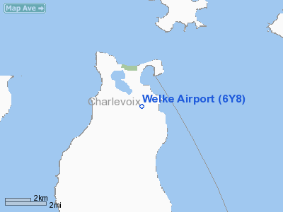
| Welke Airport |
| IATA: none – ICAO: none – FAA LID: 6Y8 |
| Summary |
| Airport type |
Public |
| Owner |
Paul Welke |
| Serves |
Beaver Island, Michigan |
| Elevation AMSL |
664 ft / 202 m |
| Coordinates |
45°43′16″N 085°31′13″W / 45.72111°N 85.52028°W / 45.72111; -85.52028 |
| Runways |
| Direction |
Length |
Surface |
| ft |
m |
| 9/27 |
2,512 |
766 |
Asphalt |
| 17/35 |
3,500 |
1,067 |
Turf |
| Statistics (2009) |
| Aircraft operations |
23,450 |
| Based aircraft |
12 |
| Source: Federal Aviation Administration |
Welke Airport (FAA LID: 6Y8) is a privately-owned public-use airport located on Beaver Island in Charlevoix County, Michigan, United States. Service to Charlevoix, Michigan is provided by Island Airways. Facilities and aircraft
Welke Airport covers an area of 200 acres (81 ha) at an elevation of 664 feet (202 m) above mean sea level. It has two runways: 9/27 is 2,512 by 30 feet (766 x 9 m) with an asphalt surface and 17/35 is 3,500 by 140 feet (1,067 x 43 m) with a turf surface.
For the 12-month period ending December 31, 2009, the airport had 23,450 aircraft operations, an average of 64 per day: 78% general aviation and 22% air taxi. At that time there were 12 aircraft based at this airport: 83% single-engine and 17% multi-engine.
Airlines and destinations
- Island Airways (Charlevoix)
The above content comes from Wikipedia and is published under free licenses – click here to read more.
Location & QuickFacts
| FAA Information Effective: | 2008-09-25 |
| Airport Identifier: | 6Y8 |
| Airport Status: | Operational |
| Longitude/Latitude: | 085-31-13.2402W/45-43-16.1847N
-85.520344/45.721162 (Estimated) |
| Elevation: | 664 ft / 202.39 m (Surveyed) |
| Land: | 200 acres |
| From nearest city: | 2 nautical miles S of Beaver Island, MI |
| Location: | Charlevoix County, MI |
| Magnetic Variation: | 05W (1985) |
Owner & Manager
| Ownership: | Privately owned |
| Owner: | Paul Welke |
| Address: | P.o. Box 112
Beaver Island, MI 49782 |
| Phone number: | 231-448-2071 |
| Manager: | Paul Welke |
| Address: | 111 Airport Drive, Po Box 80
Charlevoix, MI 49720 |
| Phone number: | 231-448-2071
AMGR RES PH 231-448-2374 |
Airport Operations and Facilities
| Airport Use: | Open to public |
| Wind indicator: | Yes |
| Segmented Circle: | Yes |
| Control Tower: | No |
| Lighting Schedule: | PHONE REQ
LIRL RY 09/27 NOT FOR PUBLIC USE; W/O PRIOR APPROVAL CALL 231-448-2071 OR 231-448-2374. LIRL LOCATEED 72 FT FM PVMT EDGE EA SIDE. |
| Landing fee charge: | No |
| Sectional chart: | Green Bay |
| Region: | AGL - Great Lakes |
| Boundary ARTCC: | ZMP - Minneapolis |
| Tie-in FSS: | LAN - Lansing |
| FSS on Airport: | No |
| FSS Toll Free: | 1-800-WX-BRIEF |
| NOTAMs Facility: | LAN (NOTAM-d service avaliable) |
Airport Communications
| CTAF: | 122.800 |
| Unicom: | 122.800 |
Airport Services
| Fuel available: | 100LL |
| Airframe Repair: | MAJOR |
| Power Plant Repair: | MAJOR |
| Bottled Oxygen: | NONE |
| Bulk Oxygen: | NONE |
Runway Information
Runway 09/27
| Dimension: | 2512 x 30 ft / 765.7 x 9.1 m |
| Surface: | ASPH, Good Condition |
| Edge Lights: | Low |
| |
Runway 09 |
Runway 27 |
| Longitude: | 085-31-32.1000W | 085-30-56.7000W |
| Latitude: | 45-43-13.2000N | 45-43-13.9000N |
| Traffic Pattern: | Left | Left |
| Markings: | Basic, Good Condition | Basic, Good Condition |
| Displaced threshold: | 450.00 ft | 240.00 ft |
| Runway End Identifier: | No | No |
| Centerline Lights: | No | No |
| Touchdown Lights: | No | No |
| Obstruction: | 40 ft trees, 201.0 ft from runway
APCH RATIO 20:1 AT DSPLCD THLD OVR +44 FT TREES 880 FT FM DSPLCD THLD; APCH RATIO 12:1 OVR +42 FT TRESS, 504 FT FM DSPLCD THLD, 144 FT L.
+ 15 FT RD, 160 FT DSTC, +25 FT PLINE, 180 FT DSTC, +40 FT TREES, 190 FT DSTC. | 15 ft road, 201.0 ft from runway, 55 ft left of centerline
APCH RATIO 10:1 OVR +60 FT TREE 600 FT FM DSPLCD THLD, 125 FT R.
+ 15 FT RD, 100 FT DSTC; + 30 FT TREES, 150 FT DSTC. |
|
Runway 17/35
| Dimension: | 3500 x 140 ft / 1066.8 x 42.7 m |
| Surface: | TURF, Fair Condition |
| |
Runway 17 |
Runway 35 |
| Longitude: | 085-31-12.1300W | 085-31-12.7700W |
| Latitude: | 45-43-35.3000N | 45-43-00.7500N |
| Elevation: | 644.00 ft | 644.00 ft |
| Traffic Pattern: | Left | Left |
| Displaced threshold: | 0.00 ft | 1350.00 ft |
| Runway End Identifier: | No | No |
| Centerline Lights: | No | No |
| Touchdown Lights: | No | No |
| Obstruction: | 18 ft tree, 360.0 ft from runway, 12 ft left of centerline, 20:1 slope to clear | 67 ft trees, 10.0 ft from runway
RY 35 APCH RATIO 20:1 AT DSPLCD THLD. |
|
Radio Navigation Aids
| ID |
Type |
Name |
Ch |
Freq |
Var |
Dist |
| SJX | NDB | St James | | 382.00 | 05W | 2.3 nm |
| CVX | NDB | Charlevoix | | 392.00 | 05W | 27.3 nm |
| BFA | NDB | Boyne Falls | | 263.00 | 06W | 41.8 nm |
| ISQ | VOR/DME | Schoolcraft County | 041X | 110.40 | 05W | 31.3 nm |
| ERY | VOR/DME | Newberry | 019X | 108.20 | 06W | 35.6 nm |
| PLN | VORTAC | Pellston | 055X | 111.80 | 06W | 36.4 nm |
Remarks
- RY 27 ACFT PARKED IN PRIMARY SURFACE - SOUTH SIDE.
- DEER ON & INVOF ARPT.
- RY 9/27 QUARRY, DIRT PILES, EQUIPMENT 165 FT N OF RY, 150 FT W OF RY 17/35.
- RWY 17 - 20 FT DROP OFF, N. END OF RWY.
- RY 17-35, EQUIP PARKED ALONG E SIDE OF RY, S END.
- PRVDD THRS ARE CORRECTLY MKD & NOTAM'D.
Images and information placed above are from
http://www.airport-data.com/airport/6Y8/
We thank them for the data!
| General Info
|
| Country |
United States
|
| State |
MICHIGAN
|
| FAA ID |
6Y8
|
| Latitude |
45-43-14.997N
|
| Longitude |
085-31-15.310W
|
| Elevation |
664 feet
|
| Near City |
BEAVER ISLAND
|
We don't guarantee the information is fresh and accurate. The data may
be wrong or outdated.
For more up-to-date information please refer to other sources.
|
|


