 |
|
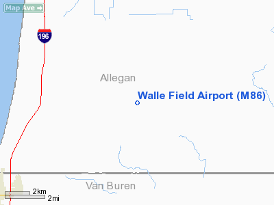
Location & QuickFacts
| FAA Information Effective: | 2008-09-25 |
| Airport Identifier: | M86 |
| Airport Status: | Operational |
| Longitude/Latitude: | 086-07-38.1070W/42-28-15.1090N
-86.127252/42.470864 (Estimated) |
| Elevation: | 635 ft / 193.55 m (Estimated) |
| Land: | 80 acres |
| From nearest city: | 2 nautical miles SW of Pullman, MI |
| Location: | Allegan County, MI |
| Magnetic Variation: | 03W (1985) |
Owner & Manager
| Ownership: | Privately owned |
| Owner: | Ed Walle
OWNER LIVES ON PREMISES. |
| Address: | 6025 107 Av
Pullman, MI 49450 |
| Phone number: | 269-236-6898 |
| Manager: | Ed Walle |
| Address: | 6025 107 Av
Pullman, MI 49450 |
| Phone number: | 269-236-6898 |
Airport Operations and Facilities
| Airport Use: | Open to public |
| Wind indicator: | No |
| Segmented Circle: | No |
| Control Tower: | No |
| Sectional chart: | Chicago |
| Region: | AGL - Great Lakes |
| Boundary ARTCC: | ZAU - Chicago |
| Tie-in FSS: | LAN - Lansing |
| FSS Toll Free: | 1-800-WX-BRIEF |
| NOTAMs Facility: | LAN (NOTAM-d service avaliable) |
Airport Communications
Runway Information
Runway 09/27
| Dimension: | 1750 x 60 ft / 533.4 x 18.3 m |
| Surface: | TURF, Poor Condition
ROUGH SFC WITH SOFT AREAS. RY SOFT IN SPRING & WHEN WET.
RY 09/27 SURFACE ROUGH AND UNEVEN WITH SOFT AREAS AND MOLE HILLS. RY SOFT IN SPRING & WHEN WET. RY NOT MOWED. |
| |
Runway 09 |
Runway 27 |
| Longitude: | 086-07-43.6800W | 086-07-21.0000W |
| Latitude: | 42-28-15.5000N | 42-28-15.5000N |
| Elevation: | 640.00 ft | 640.00 ft |
| Traffic Pattern: | Left | Left |
| Displaced threshold: | 440.00 ft | 550.00 ft |
| Obstruction: | 15 ft road, 15.0 ft from runway, 1:1 slope to clear
RWY 09 APCH RATIO 20:1 AT DSPLCD THLD, 68 FT TREES, 1360 FT DSTC, 0B. | 50 ft trees, 0.0 ft from runway, 110L/ ft right of centerline
RWY 27 APCH RATIO 0:1 AT DSPLCD THLD +60 FT TREES 0 FT DSTC, 85 FT L. ALSO, 30 FT TREES, 0 FT DSTC, 85 FT R. |
|
Radio Navigation Aids
| ID |
Type |
Name |
Ch |
Freq |
Var |
Dist |
| HLM | NDB | Holland | | 233.00 | 03W | 19.6 nm |
| HAI | NDB | Three Rivers | | 407.00 | 02W | 39.0 nm |
| BT | NDB | Batol | | 272.00 | 04W | 42.3 nm |
| PMM | VOR/DME | Pullman | 058X | 112.10 | 00E | 1.0 nm |
| ELX | VOR/DME | Keeler | 113X | 116.60 | 00E | 19.6 nm |
| AZO | VOR/DME | Kalamazoo | 027X | 109.00 | 01W | 29.1 nm |
| GRR | VOR/DME | Grand Rapids | 106Y | 115.95 | 04W | 33.7 nm |
| BTL | VORTAC | Battle Creek | 031X | 109.40 | 02W | 40.0 nm |
| MKG | VORTAC | Muskegon | 099X | 115.20 | 01W | 42.2 nm |
| GIJ | VORTAC | Gipper | 101X | 115.40 | 00E | 43.1 nm |
Remarks
Images and information placed above are from
http://www.airport-data.com/airport/M86/
We thank them for the data!
| General Info
|
| Country |
United States
|
| State |
MICHIGAN
|
| FAA ID |
M86
|
| Latitude |
42-28-15.109N
|
| Longitude |
086-07-38.107W
|
| Elevation |
635 feet
|
| Near City |
PULLMAN
|
We don't guarantee the information is fresh and accurate. The data may
be wrong or outdated.
For more up-to-date information please refer to other sources.
|
|


