 |
|
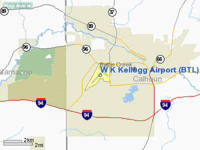
| W. K. Kellogg Regional Airport |
| IATA: BTL – ICAO: KBTL |
| Summary |
| Airport type |
Public |
| Operator |
City of Battle Creek, Michigan |
| Location |
Battle Creek, Michigan |
| Elevation AMSL |
952 ft / 290 m |
| Coordinates |
42°18′26.2″N 85°15′05.3″W / 42.307278°N 85.251472°W / 42.307278; -85.251472Coordinates: 42°18′26.2″N 85°15′05.3″W / 42.307278°N 85.251472°W / 42.307278; -85.251472 |
| Runways |
| Direction |
Length |
Surface |
| ft |
m |
| 5/23 |
10,003 |
3,049 |
Asphalt |
| 13/31 |
4,835 |
1,474 |
Asphalt |
W. K. Kellogg Regional Airport (IATA: BTL, ICAO: KBTL) is a joint civil-military general aviation, air cargo, and corporate flight facility located on the west side of the city of Battle Creek in Calhoun County, Michigan, USA. The airport is home to Western Michigan University College of Aviation, Duncan Aviation – the nation’s largest family-owned aircraft refurbishing company, WACO Classic Aircraft Corporation, Federal Express regional truck distribution facility, and other aviation businesses. The Battle Creek Field of Flight Air Show and Balloon Festival is also held annually at Kellogg Airport.
In addition, the airfield was also home of the 110th Fighter Wing(110 FW), a unit of the Michigan Air National Guard operationally gained by the Air Combat Command (ACC). The 110th Fighter Wing is the parent wing of the 172nd Fighter Squadron, which flies the A-10 Thunderbolt II when the wing left. Facilities
W. K. Kellogg Regional Airport has 2 runways.
Runways
- Runway 5/23: 10,003 x 150 ft. (3,049 x 46 m), Surface: Asphalt
- Runway 13/31: 4,835 x 100 ft. (1,474 x 30 m), Surface: Asphalt
In May 2010, construction began on a new $7.2 million, 4,100 feet (1,250 m) long by 75 feet (23 m) wide runway parallel to existing runway 5/23.
Transit
- The airport is accessible by road from Helmer Rd, and is located near I-94.
History
During World War II the airfield was used by the United States Army Air Forces.
The above content comes from Wikipedia and is published under free licenses – click here to read more.
|
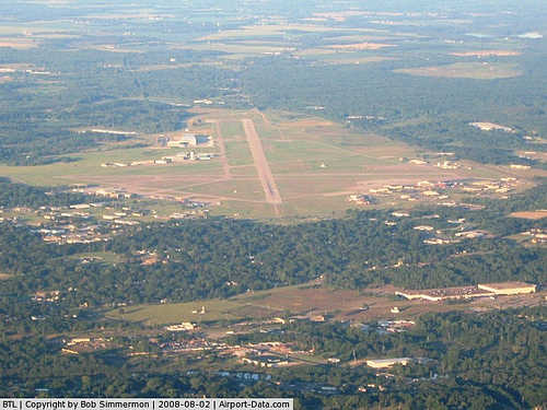 |
(Click on the photo to enlarge) |
|
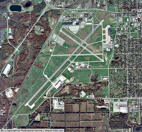 |
(Click on the photo to enlarge) |
Location & QuickFacts
| FAA Information Effective: | 2008-09-25 |
| Airport Identifier: | BTL |
| Airport Status: | Operational |
| Longitude/Latitude: | 085-15-05.3270W/42-18-26.2010N
-85.251480/42.307278 (Estimated) |
| Elevation: | 952 ft / 290.17 m (Surveyed) |
| Land: | 1500 acres |
| From nearest city: | 3 nautical miles W of Battle Creek, MI |
| Location: | Calhoun County, MI |
| Magnetic Variation: | 04W (1985) |
Owner & Manager
| Ownership: | Publicly owned |
| Owner: | City Of Battle Creek |
| Address: | 2712 W Territorial
Battle Creek, MI 49015 |
| Phone number: | 269-966-3470 |
| Manager: | Lawrence Bowron |
| Address: | 2712 W Territorial
Battle Creek, MI 49015 |
| Phone number: | 269-966-3470 |
Airport Operations and Facilities
| Airport Use: | Open to public |
| Wind indicator: | Yes |
| Segmented Circle: | No |
| Control Tower: | Yes |
| Lighting Schedule: | DUSK-DAWN
WHEN ATCT CLSD HIRL RY 05/23 PRESET ON LOW INTST TO INCR INTST & ACTVT MALSR RY 23; MIRL RY 13/31; REIL RYS 05;13 & 31 - CTAF. |
| Beacon Color: | Clear-Green (lighted land airport) |
| Landing fee charge: | No |
| Sectional chart: | Chicago |
| Region: | AGL - Great Lakes |
| Boundary ARTCC: | ZAU - Chicago |
| Tie-in FSS: | LAN - Lansing |
| FSS on Airport: | No |
| FSS Toll Free: | 1-800-WX-BRIEF |
| NOTAMs Facility: | BTL (NOTAM-d service avaliable) |
| Certification type/date: | IV A U 11/197
ARFF PRVDD 24 HRS PHONE 269-969-3349/3317. |
| Federal Agreements: | NGPSY |
Airport Communications
| CTAF: | 126.825 |
| Unicom: | 122.950 |
Airport Services
| Fuel available: | 100LLA |
| Airframe Repair: | MAJOR |
| Power Plant Repair: | MAJOR |
| Bottled Oxygen: | HIGH |
| Bulk Oxygen: | NONE |
Runway Information
Runway 05/23
| Dimension: | 10003 x 150 ft / 3048.9 x 45.7 m |
| Surface: | ASPH, Good Condition |
| Surface Treatment: | Porous Friction Course |
| Weight Limit: | Single wheel: 100000 lbs.
Dual wheel: 200000 lbs.
Dual tandem wheel: 400000 lbs.
Dual dual tandem wheel: 900000 lbs. |
| Edge Lights: | High |
| |
Runway 05 |
Runway 23 |
| Longitude: | 085-15-57.5200W | 085-14-27.4230W |
| Latitude: | 42-17-44.6420N | 42-18-57.3730N |
| Elevation: | 952.00 ft | 929.00 ft |
| Alignment: | 43 | 127 |
| ILS Type: | | ILS
|
| Traffic Pattern: | Left | Left |
| Markings: | Precision instrument, Fair Condition | Precision instrument, Fair Condition |
| Crossing Height: | 49.00 ft | 0.00 ft |
| VASI: | 4-box on left side | 4-light PAPI on left side |
| Visual Glide Angle: | 3.00° | 0.00° |
| RVR Equipment: | | touchdown |
| Approach lights: | | MALSR |
| Runway End Identifier: | Yes | |
| Obstruction: | 100 ft tree, 3625.0 ft from runway, 16 ft right of centerline, 34:1 slope to clear | 19 ft pole, 1033.0 ft from runway, 288 ft right of centerline, 43:1 slope to clear |
|
Runway 13/31
| Dimension: | 4835 x 100 ft / 1473.7 x 30.5 m |
| Surface: | ASPH, Good Condition |
| Surface Treatment: | Porous Friction Course |
| Weight Limit: | Single wheel: 40000 lbs.
Dual wheel: 65000 lbs.
Dual tandem wheel: 100000 lbs. |
| Edge Lights: | Medium |
| |
Runway 13 |
Runway 31 |
| Longitude: | 085-15-16.5280W | 085-14-24.5370W |
| Latitude: | 42-18-51.0070N | 42-18-22.8710N |
| Elevation: | 920.00 ft | 930.00 ft |
| Alignment: | 126 | 127 |
| Traffic Pattern: | Left | Left |
| Markings: | Precision instrument, Good Condition | Precision instrument, Good Condition |
| Crossing Height: | 35.00 ft | 56.00 ft |
| VASI: | 4-box on left side | 4-box on left side |
| Visual Glide Angle: | 3.00° | 3.00° |
| Runway End Identifier: | Yes | Yes |
| Obstruction: | 20 ft rr, 601.0 ft from runway, 281 ft right of centerline, 20:1 slope to clear | 15 ft road, 530.0 ft from runway, 6 ft right of centerline, 22:1 slope to clear |
|
Radio Navigation Aids
| ID |
Type |
Name |
Ch |
Freq |
Var |
Dist |
| BT | NDB | Batol | | 272.00 | 04W | 4.4 nm |
| HAI | NDB | Three Rivers | | 407.00 | 02W | 25.9 nm |
| IRS | NDB | Sturgis | | 382.00 | 04W | 30.8 nm |
| ANQ | NDB | Angola | | 347.00 | 05W | 40.8 nm |
| HLM | NDB | Holland | | 233.00 | 03W | 49.7 nm |
| AZO | VOR/DME | Kalamazoo | 027X | 109.00 | 01W | 14.1 nm |
| LFD | VOR/DME | Litchfield | 049X | 111.20 | 05W | 26.2 nm |
| GRR | VOR/DME | Grand Rapids | 106Y | 115.95 | 04W | 30.8 nm |
| JXN | VOR/DME | Jackson | 033X | 109.60 | 05W | 35.4 nm |
| PMM | VOR/DME | Pullman | 058X | 112.10 | 00E | 39.1 nm |
| ELX | VOR/DME | Keeler | 113X | 116.60 | 00E | 40.0 nm |
| BTL | VORTAC | Battle Creek | 031X | 109.40 | 02W | 0.2 nm |
| LAN | VORTAC | Lansing | 045X | 110.80 | 05W | 34.8 nm |
Remarks
- DEER & BIRDS ON & INVOF ARPT.
- FOR CUSTOMS CALL 269-965-3349.
- 48 HRS PPR FOR UNSKED ACR OPNS WITH MORE THAN 30 PSGR SEATS CALL AMGR 269-966-3470.
- EXTENSIVE PILOT TRAINING WITHIN 25 NM OF BTL VOR.
- INDEX C ARFF AVAIL ON REQUEST - 48 HRS PPR 269-966-3470.
- N SIDE AFLD PPR ACFT MON-FRI (+UTA'S EX HOL) 1200-2130Z++ C269-969-3281, DSN580-3281, OPS HRS MON-FRI 1130-2200Z++ CTC BATTLE OPS 10 MIN PRIOR TO ARR.
Images and information placed above are from
http://www.airport-data.com/airport/BTL/
We thank them for the data!
| General Info
|
| Country |
United States
|
| State |
MICHIGAN
|
| FAA ID |
BTL
|
| Latitude |
42-18-26.201N
|
| Longitude |
085-15-05.327W
|
| Elevation |
952 feet
|
| Near City |
BATTLE CREEK
|
We don't guarantee the information is fresh and accurate. The data may
be wrong or outdated.
For more up-to-date information please refer to other sources.
|
|


