 |
|
| Tuscola Area Airport |
| IATA: none – ICAO: KCFS – FAA LID: CFS |
| Summary |
| Airport type |
Public |
| Owner |
Tuscola Area Airport Authority |
| Serves |
Caro, Michigan |
| Elevation AMSL |
701 ft / 214 m |
| Coordinates |
43°27′32″N 083°26′44″W / 43.45889°N 83.44556°W / 43.45889; -83.44556 |
| Runways |
| Direction |
Length |
Surface |
| ft |
m |
| 5/23 |
4,300 |
1,311 |
Asphalt |
| 12/30 |
2,300 |
701 |
Turf |
| Statistics (2008) |
| Aircraft operations |
10,200 |
| Based aircraft |
48 |
| Source: Federal Aviation Administration |
Tuscola Area Airport (ICAO: KCFS, FAA LID: CFS, formerly 78D) is a public use airport located three nautical miles (6 km) southwest of the central business district of Caro, a city in Tuscola County, Michigan, United States. It is owned by the Tuscola Area Airport Authority. According to the FAA's National Plan of Integrated Airport Systems for 2009–2013, it is categorized as a general aviation airport.
Although many U.S. airports use the same three-letter location identifier for the FAA and IATA, this airport is assigned CFS by the FAA and no designation from the IATA (which assigned CFS to Coffs Harbour Airport in Coffs Harbour, New South Wales, Australia). Facilities and aircraft
Tuscola Area Airport covers an area of 260 acres (105 ha) at an elevation of 701 feet (214 m) above mean sea level. It has two runways: 5/23 is 4,300 by 75 feet (1,311 x 23 m) with an asphalt pavement; 12/30 is 2,300 by 110 feet (701 x 34 m) with a turf surface. The airport is not staffed regularly.
For the 12-month period ending December 31, 2008, the airport had 10,200 general aviation aircraft operations, an average of 27 per day. At that time there were 48 aircraft based at this airport: 85.4% single-engine, 4.2% multi-engine, 2.1% jet and 8.3% helicopter.
Transit
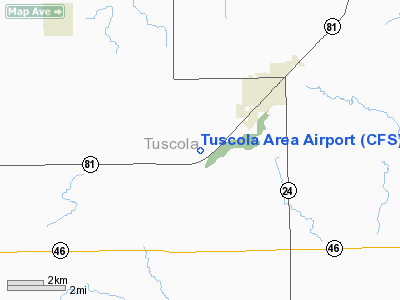
The airport is accessible by road from M-81, and is close to M-24.
The above content comes from Wikipedia and is published under free licenses – click here to read more.
Location & QuickFacts
| FAA Information Effective: | 2008-09-25 |
| Airport Identifier: | CFS |
| Airport Status: | Operational |
| Longitude/Latitude: | 083-26-43.7120W/43-27-31.8530N
-83.445476/43.458848 (Estimated) |
| Elevation: | 701 ft / 213.66 m (Surveyed) |
| Land: | 260 acres |
| From nearest city: | 3 nautical miles SW of Caro, MI |
| Location: | Tuscola County, MI |
| Magnetic Variation: | 06W (1985) |
Owner & Manager
| Ownership: | Publicly owned |
| Owner: | Tuscola Area Airport Authority |
| Address: | 157 N. State St.
Caro, MI 48723 |
| Phone number: | 989-673-2849 |
| Manager: | Eric M. Engler |
| Address: | 157 N. State St
Caro, MI 48723 |
| Phone number: | 989-673-4301 |
Airport Operations and Facilities
| Airport Use: | Open to public |
| Wind indicator: | Yes |
| Segmented Circle: | Yes |
| Control Tower: | No |
| Lighting Schedule: | DUSK-DAWN
ACTVT MIRL RY 05/23; REIL & PAPI RYS 05 & 23 - CTAF. |
| Beacon Color: | Clear-Green (lighted land airport) |
| Landing fee charge: | No |
| Sectional chart: | Detroit |
| Region: | AGL - Great Lakes |
| Boundary ARTCC: | ZOB - Cleveland |
| Tie-in FSS: | LAN - Lansing |
| FSS on Airport: | No |
| FSS Toll Free: | 1-800-WX-BRIEF |
| NOTAMs Facility: | CFS (NOTAM-d service avaliable) |
| Federal Agreements: | NGY |
Airport Communications
| CTAF: | 123.000 |
| Unicom: | 123.000 |
Airport Services
| Fuel available: | 100LLA
FOR FUEL AFT HRS CALL 989-673-2849. |
| Airframe Repair: | MAJOR |
| Power Plant Repair: | MAJOR |
| Bottled Oxygen: | NONE |
| Bulk Oxygen: | NONE |
Runway Information
Runway 05/23
| Dimension: | 4300 x 75 ft / 1310.6 x 22.9 m |
| Surface: | ASPH, Fair Condition |
| Edge Lights: | Medium |
| |
Runway 05 |
Runway 23 |
| Longitude: | 083-27-13.4630W | 083-26-27.6570W |
| Latitude: | 43-27-14.5770N | 43-27-40.8490N |
| Elevation: | 686.00 ft | 701.00 ft |
| Alignment: | 52 | 127 |
| Traffic Pattern: | Left | Left |
| Markings: | Non-precision instrument, Fair Condition | Non-precision instrument, Fair Condition |
| Crossing Height: | 25.00 ft | 0.00 ft |
| VASI: | 4-light PAPI on left side | 4-light PAPI on left side |
| Visual Glide Angle: | 3.00° | 4.00° |
| Runway End Identifier: | Yes | Yes |
| Obstruction: | 79 ft trees, 1583.0 ft from runway, 130 ft right of centerline, 17:1 slope to clear | 23 ft trees, 581.0 ft from runway, 75 ft right of centerline, 16:1 slope to clear |
|
Runway 12/30
| Dimension: | 2300 x 110 ft / 701.0 x 33.5 m |
| Surface: | TURF, Fair Condition |
| |
Runway 12 |
Runway 30 |
| Longitude: | 083-26-44.3810W | 083-26-17.4340W |
| Latitude: | 43-27-45.3100N | 43-27-33.8780N |
| Alignment: | 120 | 127 |
| Traffic Pattern: | Left | Left |
| Displaced threshold: | 0.00 ft | 500.00 ft |
| Obstruction: | 70 ft trees, 1750.0 ft from runway, 25:1 slope to clear | 49 ft trees, 594.0 ft from runway, 12:1 slope to clear
RWY 30 APCH RATIO 22:1 AT DSPLCD THLD; 49 FT TREES 1094 FT FM DSPLCD THLD. |
|
Radio Navigation Aids
| ID |
Type |
Name |
Ch |
Freq |
Var |
Dist |
| HYX | NDB | Browne | | 385.00 | 06W | 18.1 nm |
| MBS | VOR/DME | Saginaw | 076X | 112.90 | 03W | 27.9 nm |
| BAX | VOR/DME | Bad Axe | 019X | 108.20 | 05W | 28.0 nm |
| FNT | VORTAC | Flint | 116X | 116.90 | 06W | 32.4 nm |
| ECK | VORTAC | Peck | 087X | 114.00 | 07W | 34.1 nm |
| PSI | VORTAC | Pontiac | 047X | 111.00 | 03W | 45.7 nm |
Remarks
- DEER ON ARPT.
- TWY MKD WITH REFLECTORS.
- GCO AVBL ON FREQ 121.725 THRU MBS CD AND FLT SVCS.
Images and information placed above are from
http://www.airport-data.com/airport/CFS/
We thank them for the data!
| General Info
|
| Country |
United States
|
| State |
MICHIGAN
|
| FAA ID |
CFS
|
| Latitude |
43.458847
43° 27' 31.85" N
|
| Longitude |
-83.445475
083° 26' 43.71" W
|
| Elevation |
701 feet
214 meters
|
| Type |
Civil
|
| Magnetic Variation |
007° W (01/06)
|
| Beacon |
Yes
|
| Operating Agency |
U.S.CIVIL AIRPORT WHEREIN PERMIT COVERS USE BY TRANSIT MILITARY AIRCRAFT
|
| Daylight Saving Time |
Second Sunday in March at 0200 to first Sunday in November at 0200 local time (Exception Arizona and that portion of Indiana in the Eastern Time Zone)
|
We don't guarantee the information is fresh and accurate. The data may
be wrong or outdated.
For more up-to-date information please refer to other sources.
|
|


