 |
|
| Tulip City Airport |
| IATA: none – ICAO: KBIV – FAA LID: BIV |
| Summary |
| Airport type |
Public |
| Owner |
City of Holland |
| Serves |
Holland, Michigan |
| Elevation AMSL |
698 ft / 213 m |
| Coordinates |
42°44′34″N 086°06′28″W / 42.74278°N 86.10778°W / 42.74278; -86.10778 |
| Runways |
| Direction |
Length |
Surface |
| ft |
m |
| 8/26 |
6,002 |
1,829 |
Asphalt |
| Statistics (2008) |
| Aircraft operations |
52,520 |
| Based aircraft |
51 |
| Source: Federal Aviation Administration |
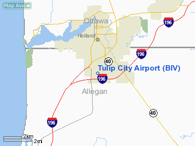
Tulip City Airport (ICAO: KBIV, FAA LID: BIV) is a public-use airport located two nautical miles (3.7 km) south of the central business district of Holland, a city in Allegan County, Michigan, United States. According to the FAA's National Plan of Integrated Airport Systems for 2009–2013, it is categorized as a general aviation airport.
Owned by the City of Holland and operated by Tulip City Air, the airport relies on user fees, federal and state grants and donations to operate. The reason is a provision in the city charter that prohibits tax dollars from being used for airport operations. However, a regional airport authority was authorized by area voters in November 2008.
Although many U.S. airports use the same three-letter location identifier for the FAA and IATA, this airport is assigned BIV by the FAA and no designation from the IATA (which assigned BIV to Bria Airport in Bria, Central African Republic).
Facilities and aircraft
Tulip City Airport covers an area of 432 acres (175 ha) at an elevation of 698 feet (213 m) above mean sea level. It has one runway designated 8/26 with an asphalt surface measuring 6,002 by 100 feet (1,829 x 30 m). Passenger loading is from the tarmac. Flights range from light sport aircraft to business jets; it has no regularly scheduled commercial flights. A full-service fixed base operator (FBO) offers aircraft rental, flight instruction, charter flights, and aircraft maintenance.
For the 12-month period ending December 31, 2008, the airport had 52,520 aircraft operations, an average of 143 per day: 92% general aviation, 8% air taxi, and <1% military. At that time there were 51 aircraft based at this airport: 64.7% single-engine, 15.7% multi-engine and 19.6% jet.
The above content comes from Wikipedia and is published under free licenses – click here to read more.
Location & QuickFacts
| FAA Information Effective: | 2008-09-25 |
| Airport Identifier: | BIV |
| Airport Status: | Operational |
| Longitude/Latitude: | 086-06-26.5000W/42-44-34.3000N
-86.107361/42.742861 (Estimated) |
| Elevation: | 698 ft / 212.75 m (Surveyed) |
| Land: | 432 acres |
| From nearest city: | 2 nautical miles S of Holland, MI |
| Location: | Allegan County, MI |
| Magnetic Variation: | 04W (1995) |
Owner & Manager
| Ownership: | Publicly owned |
| Owner: | City Of Holland |
| Address: | 270 S. River Ave
Holland, MI 49423 |
| Phone number: | 616-394-1380 |
| Manager: | Ron Ludema |
| Address: | 1581 S Washington Ave
Holland, MI 49423 |
| Phone number: | 616-392-7831 |
Airport Operations and Facilities
| Airport Use: | Open to public |
| Wind indicator: | Yes |
| Segmented Circle: | Yes |
| Control Tower: | No |
| Lighting Schedule: | DUSK-DAWN
HIRL RY 08/26 PRESET LOW INTST; TO INCR INTST & ACTVT MALSR RY 26; REIL RY 08; PAPI RYS 08 & 26 - CTAF. |
| Beacon Color: | Clear-Green (lighted land airport) |
| Landing fee charge: | Yes
LNDG FEE WAIVED WITH MIN FUEL PURCHASE. |
| Sectional chart: | Chicago |
| Region: | AGL - Great Lakes |
| Boundary ARTCC: | ZAU - Chicago |
| Tie-in FSS: | LAN - Lansing |
| FSS on Airport: | No |
| FSS Toll Free: | 1-800-WX-BRIEF |
| NOTAMs Facility: | BIV (NOTAM-d service avaliable) |
| Federal Agreements: | NGY |
Airport Communications
| CTAF: | 123.050 |
| Unicom: | 123.050 |
Airport Services
| Fuel available: | 100LLA |
| Airframe Repair: | MAJOR |
| Power Plant Repair: | MAJOR |
| Bottled Oxygen: | NONE |
| Bulk Oxygen: | HIGH/LOW |
Runway Information
Runway 08/26
| Dimension: | 6264 x 100 ft / 1909.3 x 30.5 m |
| Surface: | ASPH, Good Condition |
| Surface Treatment: | Saw-cut or plastic Grooved |
| Weight Limit: | Single wheel: 75000 lbs.
Dual wheel: 160000 lbs.
Dual tandem wheel: 175000 lbs. |
| Edge Lights: | High |
| |
Runway 08 |
Runway 26 |
| Longitude: | 086-07-07.7617W | 086-05-45.1710W |
| Latitude: | 42-44-28.7235N | 42-44-39.7706N |
| Elevation: | 698.00 ft | 688.00 ft |
| Alignment: | 80 | 127 |
| ILS Type: | | ILS/DME
|
| Traffic Pattern: | Right | Left |
| Markings: | Precision instrument, Good Condition | Precision instrument, Good Condition |
| Crossing Height: | 40.00 ft | 25.00 ft |
| VASI: | 4-light PAPI on left side | 4-light PAPI on left side |
| Visual Glide Angle: | 3.00° | 3.00° |
| Approach lights: | | MALSR |
| Runway End Identifier: | Yes | Yes |
| Obstruction: | , 50:1 slope to clear | 43 ft trees, 1662.0 ft from runway, 275 ft right of centerline, 34:1 slope to clear |
|
Radio Navigation Aids
| ID |
Type |
Name |
Ch |
Freq |
Var |
Dist |
| HLM | NDB | Holland | | 233.00 | 03W | 3.9 nm |
| BT | NDB | Batol | | 272.00 | 04W | 46.8 nm |
| PMM | VOR/DME | Pullman | 058X | 112.10 | 00E | 16.6 nm |
| GRR | VOR/DME | Grand Rapids | 106Y | 115.95 | 04W | 27.1 nm |
| ELX | VOR/DME | Keeler | 113X | 116.60 | 00E | 36.0 nm |
| AZO | VOR/DME | Kalamazoo | 027X | 109.00 | 01W | 39.1 nm |
| MKG | VORTAC | Muskegon | 099X | 115.20 | 01W | 25.8 nm |
| BTL | VORTAC | Battle Creek | 031X | 109.40 | 02W | 46.0 nm |
Remarks
- DEER & BIRDS ON & INVOF ARPT.
Images and information placed above are from
http://www.airport-data.com/airport/BIV/
We thank them for the data!
| General Info
|
| Country |
United States
|
| State |
MICHIGAN
|
| FAA ID |
BIV
|
| Latitude |
42-44-35.400N
|
| Longitude |
086-06-18.100W
|
| Elevation |
687 feet
|
| Near City |
HOLLAND
|
We don't guarantee the information is fresh and accurate. The data may
be wrong or outdated.
For more up-to-date information please refer to other sources.
|
|


