 |
|
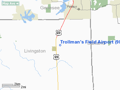
Location & QuickFacts
| FAA Information Effective: | 2008-09-25 |
| Airport Identifier: | 9MI6 |
| Airport Status: | Operational |
| Longitude/Latitude: | 083-45-17.8160W/42-44-21.1030N
-83.754949/42.739195 (Estimated) |
| Elevation: | 990 ft / 301.75 m (Estimated) |
| Land: | 80 acres |
| From nearest city: | 6 nautical miles S of Fenton, MI |
| Location: | Livingston County, MI |
| Magnetic Variation: | 05W (1985) |
Owner & Manager
| Ownership: | Privately owned |
| Owner: | Joseph L Trollman D.o. |
| Address: | 201 E Caroline St
Fenton, MI 48430 |
| Phone number: | 313-629-4187 |
| Manager: | Joseph L Trollman D.o. |
| Address: | 201 E Caroline St
Fenton, MI 48430 |
| Phone number: | 313-629-4187 |
Airport Operations and Facilities
| Airport Use: | Private |
| Wind indicator: | Yes |
| Segmented Circle: | No |
| Control Tower: | No |
| Sectional chart: | Detroit |
| Region: | AGL - Great Lakes |
| Boundary ARTCC: | ZOB - Cleveland |
| Tie-in FSS: | LAN - Lansing |
| FSS on Airport: | No |
| FSS Toll Free: | 1-800-WX-BRIEF |
Runway Information
Runway 01/19
| Dimension: | 2500 x 250 ft / 762.0 x 76.2 m |
| Surface: | TURF, |
| |
Runway 01 |
Runway 19 |
| Traffic Pattern: | Left | Left |
| Displaced threshold: | 20.00 ft | 230.00 ft |
| Obstruction: | 50 ft trees | 30 ft pline |
|
Runway 12/30
| Dimension: | 1800 x 100 ft / 548.6 x 30.5 m |
| Surface: | TURF, |
| |
Runway 12 |
Runway 30 |
| Traffic Pattern: | Left | Left |
| Displaced threshold: | 20.00 ft | 210.00 ft |
| Obstruction: | 50 ft trees | 40 ft trees |
|
Radio Navigation Aids
| ID |
Type |
Name |
Ch |
Freq |
Var |
Dist |
| OZW | NDB | Howell | | 243.00 | 05W | 12.1 nm |
| HYX | NDB | Browne | | 385.00 | 06W | 41.9 nm |
| VQ | NDB | Cargl | | 230.00 | 05W | 42.3 nm |
| TCU | NDB | Tecumseh | | 239.00 | 04W | 42.6 nm |
| G | NDB | Golf | | 398.00 | 05W | 43.2 nm |
| RYS | NDB | Grosse Ile | | 419.00 | 06W | 46.7 nm |
| QG | NDB | Windsor | | 353.00 | 06W | 46.9 nm |
| MTC | TACAN | Selfridge | 064X | | 06W | 41.5 nm |
| DXO | VOR/DME | Detroit | 081X | 113.40 | 06W | 36.0 nm |
| JXN | VOR/DME | Jackson | 033X | 109.60 | 05W | 42.5 nm |
| MBS | VOR/DME | Saginaw | 076X | 112.90 | 03W | 49.7 nm |
| PSI | VORTAC | Pontiac | 047X | 111.00 | 03W | 10.1 nm |
| FNT | VORTAC | Flint | 116X | 116.90 | 06W | 13.7 nm |
| SVM | VORTAC | Salem | 090X | 114.30 | 03W | 21.1 nm |
| LAN | VORTAC | Lansing | 045X | 110.80 | 05W | 41.6 nm |
| CRL | VORTAC | Carleton | 104X | 115.70 | 03W | 43.6 nm |
| YIP | VOT | Willow Run | | 112.00 | | 32.1 nm |
| DTW | VOT | Detroit Met Wayne | | 109.80 | | 35.3 nm |
| DET | VOT | Detroit City | | 111.60 | | 38.4 nm |
Remarks
- PRVDD THRS ARE DSPLCD TO PRVD 20:1 APCH CLRNC & ADEQUATE RWY LENGTH IS AVBL FOR INTENDED OPNS.
Images and information placed above are from
http://www.airport-data.com/airport/9MI6/
We thank them for the data!
| General Info
|
| Country |
United States
|
| State |
MICHIGAN
|
| FAA ID |
9MI6
|
| Latitude |
42-44-21.103N
|
| Longitude |
083-45-17.816W
|
| Elevation |
990 feet
|
| Near City |
FENTON
|
We don't guarantee the information is fresh and accurate. The data may
be wrong or outdated.
For more up-to-date information please refer to other sources.
|
|


