|
|
| Toledo Suburban Airport |
 |
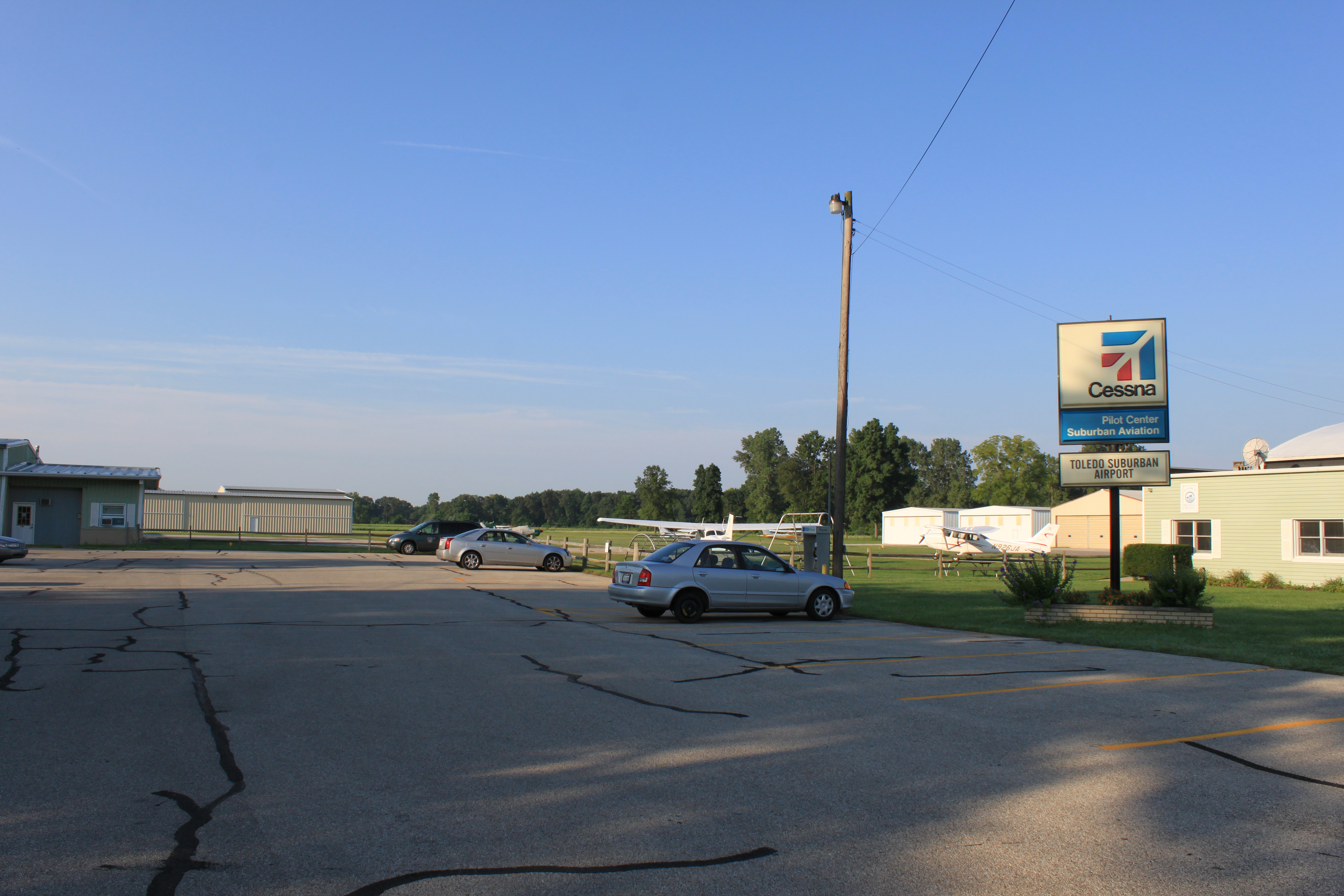
| Airport entrance, Section Rd. |
| IATA: none – ICAO: KDUH – FAA LID: DUH |
| Summary |
| Airport type |
Public |
| Owner |
Suburban Holdings Inc. |
| Serves |
Lambertville, Michigan |
| Elevation AMSL |
669 ft / 204 m |
| Coordinates |
41°44′09″N 083°39′21″W / 41.73583°N 83.65583°W / 41.73583; -83.65583 |
| Runways |
| Direction |
Length |
Surface |
| ft |
m |
| 9/27 |
4,851 |
1,479 |
Asphalt |
| Statistics (2008) |
| Aircraft operations |
38,000 |
| Based aircraft |
48 |
| Source: Federal Aviation Administration |
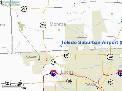
Toledo Suburban Airport (ICAO: KDUH, FAA LID: DUH) is a public use airport located two nautical miles (3.7 km) southwest of the central business district of Lambertville, a city in Monroe County, Michigan, United States. It is located just north of Michigan's border with Ohio and northeast of the city of Toledo, Ohio. According to the FAA's National Plan of Integrated Airport Systems for 2009–2013, it is categorized as a general aviation airport.
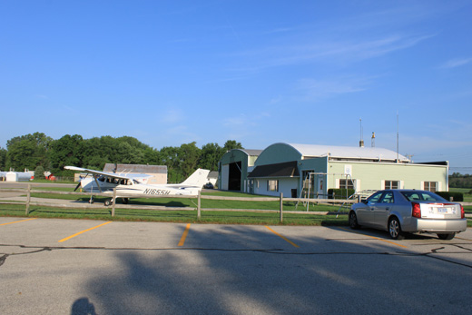 | |
Hangar & Airport office |
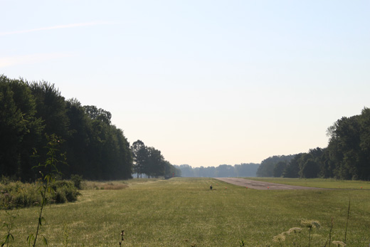 | |
Runway facing east from Whiteford Rd. |
Although many U.S. airports use the same three-letter location identifier for the FAA and IATA, this airport is assigned DUH by the FAA and no designation from the IATA. Facilities and aircraft
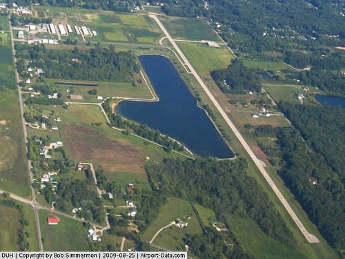
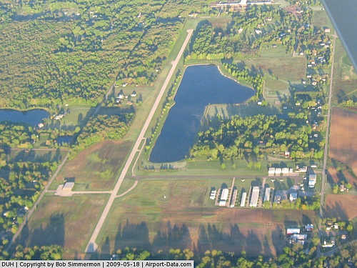
Toledo Suburban Airport covers an area of 90 acres (36 ha) at an elevation of 669 feet (204 m) above mean sea level. It has one runway designated 9/27 with an asphalt surface measuring 4,851 by 50 feet (1,479 x 15 m). The airport is staffed from 8AM until 6PM. This airport provides flight instructors, GA piston maintenance (specializing in Cessna restarts), Cessna Parts, hangers, tie downs, and has 100LL & Jet A fuel.Template:Chief Flight instructor
For the 12-month period ending December 31, 2008, the airport had 38,000 general aviation aircraft operations, an average of 104 per day. At that time there were 48 aircraft based at this airport: 88% single-engine, 8% multi-engine, 2% helicopter and 2% ultralight.
Transit
The airport is accessible by road from Section Rd, and is close to US-23.
The above content comes from Wikipedia and is published under free licenses – click here to read more.
|
 |
(Click on the photo to enlarge) |
|
 |
(Click on the photo to enlarge) |
|
 |
(Click on the photo to enlarge) |
Location & QuickFacts
| FAA Information Effective: | 2008-09-25 |
| Airport Identifier: | DUH |
| Airport Status: | Operational |
| Longitude/Latitude: | 083-39-20.7500W/41-44-09.1500N
-83.655764/41.735875 (Estimated) |
| Elevation: | 669 ft / 203.91 m (Surveyed) |
| Land: | 90 acres |
| From nearest city: | 2 nautical miles SW of Lambertville, MI |
| Location: | Monroe County, MI |
| Magnetic Variation: | 02W (1980) |
Owner & Manager
| Ownership: | Privately owned |
| Owner: | Suburban Holdings Inc. |
| Address: | 4383 Section Rd
Ottawa Lake, MI 49267 |
| Phone number: | 734-856-6103 |
| Manager: | Thomas Trumbull |
| Address: | 4383 Section Rd
Ottawa Lake, MI 49267 |
| Phone number: | 734-856-6103 |
Airport Operations and Facilities
| Airport Use: | Open to public |
| Wind indicator: | Yes |
| Segmented Circle: | Yes |
| Control Tower: | No |
| Lighting Schedule: | DUSK-DAWN
ACTVT MIRL RY 09/27 - CTAF. |
| Beacon Color: | Clear-Green (lighted land airport) |
| Landing fee charge: | No |
| Sectional chart: | Detroit |
| Region: | AGL - Great Lakes |
| Boundary ARTCC: | ZOB - Cleveland |
| Tie-in FSS: | LAN - Lansing |
| FSS on Airport: | No |
| FSS Toll Free: | 1-800-WX-BRIEF |
| NOTAMs Facility: | DUH (NOTAM-d service avaliable) |
| Federal Agreements: | N |
Airport Communications
| CTAF: | 122.700 |
| Unicom: | 122.700 |
Airport Services
| Fuel available: | 100LLA |
| Airframe Repair: | MAJOR |
| Power Plant Repair: | MAJOR |
| Bottled Oxygen: | NONE |
| Bulk Oxygen: | NONE |
Runway Information
Runway 09/27
| Dimension: | 4851 x 50 ft / 1478.6 x 15.2 m |
| Surface: | ASPH, Good Condition |
| Edge Lights: | Non-standard lighting system
MIRL NSTD DSPLCD THLD CONFIGURATION; ONE LGT INBOARD RY 27. |
| |
Runway 09 |
Runway 27 |
| Longitude: | 083-39-52.7000W | 083-38-48.8000W |
| Latitude: | 41-44-07.9000N | 41-44-10.4000N |
| Alignment: | 87 | 127 |
| Traffic Pattern: | Left | Left |
| Markings: | Basic, Fair Condition | Basic, Fair Condition |
| Displaced threshold: | 1298.00 ft | 1017.00 ft |
| Runway End Identifier: | No | No |
| Centerline Lights: | No | No |
| Touchdown Lights: | No | No |
| Obstruction: | 75 ft trees, 476.0 ft from runway, 3:1 slope to clear
RWY 09 APCH RATIO 5:1 AT DSPLCD THLD DUE TO 60 FT TREES, 300 FT DSTC, 150 FT R. | 15 ft road, 323.0 ft from runway, 85 ft right of centerline, 5:1 slope to clear
APCH RATIO 14:1 AT DSPLCD OVER 90 FT TREES 1288 FT DSTC, 205 FT L. |
|
Radio Navigation Aids
| ID |
Type |
Name |
Ch |
Freq |
Var |
Dist |
| ADG | NDB | Adrian | | 278.00 | 06W | 20.5 nm |
| TCU | NDB | Tecumseh | | 239.00 | 04W | 20.7 nm |
| USE | NDB | Fulton | | 375.00 | 05W | 22.7 nm |
| RYS | NDB | Grosse Ile | | 419.00 | 06W | 31.4 nm |
| FZI | NDB | Fostoria | | 379.00 | 05W | 34.9 nm |
| PCW | NDB | Port Clinton | | 423.00 | 06W | 37.7 nm |
| BYN | NDB | Bryan | | 260.00 | 04W | 39.5 nm |
| G | NDB | Golf | | 398.00 | 05W | 40.9 nm |
| DFI | NDB | Defiance | | 246.00 | 05W | 42.3 nm |
| BNR | NDB | Benton Ridge | | 334.00 | 05W | 43.0 nm |
| TII | NDB | Tiffin | | 269.00 | 05W | 43.3 nm |
| PT | NDB | Pelee Island | | 283.00 | 05W | 44.3 nm |
| PDR | NDB | Ottawa | | 233.00 | 05W | 44.7 nm |
| VQ | NDB | Cargl | | 230.00 | 05W | 48.7 nm |
| QG | NDB | Windsor | | 353.00 | 06W | 49.4 nm |
| TOL | TACAN | Toledo | 072X | | 05W | 10.7 nm |
| MAH | VOR | Marathon | | 114.90 | 05W | 43.3 nm |
| VWV | VOR/DME | Waterville | 078X | 113.10 | 02W | 17.1 nm |
| DXO | VOR/DME | Detroit | 081X | 113.40 | 06W | 31.5 nm |
| JXN | VOR/DME | Jackson | 033X | 109.60 | 05W | 47.7 nm |
| YQG | VOR/DME | Windsor | 085X | 113.80 | 06W | 48.2 nm |
| SKY | VOR/DME | Sandusky | 029X | 109.20 | 04W | 48.5 nm |
| CRL | VORTAC | Carleton | 104X | 115.70 | 03W | 20.8 nm |
| SVM | VORTAC | Salem | 090X | 114.30 | 03W | 40.5 nm |
| FDY | VORTAC | Findlay | 019X | 108.20 | 02W | 47.1 nm |
| YIP | VOT | Willow Run | | 112.00 | | 30.5 nm |
| DTW | VOT | Detroit Met Wayne | | 109.80 | | 32.3 nm |
| DET | VOT | Detroit City | | 111.60 | | 49.3 nm |
Remarks
- 4 FT FENCE 110 FT N SIDE OF RWY. CROPS 50 FT S SIDE OF RWY IN PRIM SFC.
- DEER ON & INVOF ARPT.
- GCO AVBL ON FREQ 121.725 THRU TOL CD & FLT SVCS.
- PARALLEL TWY CLSD INDEF.
- EXISTED PRIOR TO 1959.
Images and information placed above are from
http://www.airport-data.com/airport/DUH/
We thank them for the data!
| General Info
|
| Country |
United States
|
| State |
MICHIGAN
|
| FAA ID |
DUH
|
| Latitude |
41-44-09.159N
|
| Longitude |
083-39-19.478W
|
| Elevation |
669 feet
|
| Near City |
LAMBERTVILLE
|
We don't guarantee the information is fresh and accurate. The data may
be wrong or outdated.
For more up-to-date information please refer to other sources.
|
|