 |
|
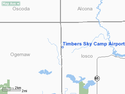
Location & QuickFacts
| FAA Information Effective: | 2008-09-25 |
| Airport Identifier: | 84MI |
| Airport Status: | Operational |
| Longitude/Latitude: | 083-52-54.9630W/44-28-10.0560N
-83.881934/44.469460 (Estimated) |
| Elevation: | 945 ft / 288.04 m (Estimated) |
| Land: | 74 acres |
| From nearest city: | 0 nautical miles NE of South Branch, MI |
| Location: | Iosco County, MI |
| Magnetic Variation: | 06W (1985) |
Owner & Manager
| Ownership: | Privately owned |
| Owner: | Mrs Fay Taber |
| Address: |
South Branch, MI 48761 |
| Phone number: | 517-257-3609 |
| Manager: | Mrs Fay Taber |
| Address: |
South Branch, MI 48761 |
| Phone number: | 517-345-1453 |
Airport Operations and Facilities
| Airport Use: | Private |
| Wind indicator: | Yes |
| Segmented Circle: | No |
| Control Tower: | No |
| Landing fee charge: | No |
| Sectional chart: | Lake Huron |
| Region: | AGL - Great Lakes |
| Boundary ARTCC: | ZMP - Minneapolis |
| Tie-in FSS: | LAN - Lansing |
| FSS on Airport: | No |
| FSS Toll Free: | 1-800-WX-BRIEF |
Airport Services
| Bottled Oxygen: | NONE |
| Bulk Oxygen: | NONE |
Runway Information
Runway 05/23
| Dimension: | 1930 x 115 ft / 588.3 x 35.1 m |
| Surface: | TURF, Fair Condition |
| |
Runway 05 |
Runway 23 |
| Longitude: | 083-53-04.0000W | 083-52-43.6100W |
| Latitude: | 44-28-02.5900N | 44-28-14.8400N |
| Elevation: | 945.00 ft | 945.00 ft |
| Traffic Pattern: | Left | Left |
| Displaced threshold: | 820.00 ft | 700.00 ft |
| Runway End Identifier: | No | No |
| Centerline Lights: | No | No |
| Touchdown Lights: | No | No |
| Obstruction: | 70 ft trees, 200.0 ft from runway, 3:1 slope to clear
APCH RATIO 17:1 AT DSPLCD THR. | 53 ft trees, 160.0 ft from runway, 3:1 slope to clear
APCH RATIO 20:1 AT DSPLCD THR. |
|
Runway 15/33
| Dimension: | 2100 x 125 ft / 640.1 x 38.1 m |
| Surface: | TURF, Fair Condition |
| |
Runway 15 |
Runway 33 |
| Longitude: | 083-53-03.6200W | 083-52-48.2800W |
| Latitude: | 44-28-20.3700N | 44-28-02.7900N |
| Elevation: | 945.00 ft | 945.00 ft |
| Traffic Pattern: | Left | Left |
| Displaced threshold: | 700.00 ft | 0.00 ft |
| Runway End Identifier: | No | No |
| Centerline Lights: | No | No |
| Touchdown Lights: | No | No |
| Obstruction: | 20 ft pline, 83 ft right of centerline
APCH RATIO 17:1 AT DSPLCD THR. | 30 ft trees/brush, 0.0 ft from runway, 63 ft right of centerline |
|
Radio Navigation Aids
| ID |
Type |
Name |
Ch |
Freq |
Var |
Dist |
| BHW | NDB | Hardwood | | 236.00 | 06W | 15.9 nm |
| GDW | NDB | Wiggins | | 209.00 | 04W | 39.4 nm |
| GYG | NDB | Grayling | | 359.00 | 06W | 43.9 nm |
| CGG | VOR | Grayling | | 109.80 | 06W | 38.4 nm |
| BXZ | VOR/DME | West Branch | 079X | 113.20 | 06W | 18.8 nm |
| ASP | VOR/DME | Au Sable | 108X | 116.10 | 07W | 21.0 nm |
| HTL | VOR/DME | Houghton Lake | 053X | 111.60 | 05W | 34.3 nm |
| GLR | VOR/DME | Gaylord | 029X | 109.20 | 06W | 47.9 nm |
| APN | VORTAC | Alpena | 025X | 108.80 | 07W | 39.4 nm |
Remarks
- RY 33 +65' TREES IN PRIM SURF FIRST 200' OF RY 65'B CNTRLN.
- CLSD WINTER MOS. NO SNOW REMOVAL.
- PRIOR TO 1959.
Images and information placed above are from
http://www.airport-data.com/airport/84MI/
We thank them for the data!
| General Info
|
| Country |
United States
|
| State |
MICHIGAN
|
| FAA ID |
84MI
|
| Latitude |
44-28-10.056N
|
| Longitude |
083-52-54.963W
|
| Elevation |
945 feet
|
| Near City |
SOUTH BRANCH
|
We don't guarantee the information is fresh and accurate. The data may
be wrong or outdated.
For more up-to-date information please refer to other sources.
|
|


