|
|
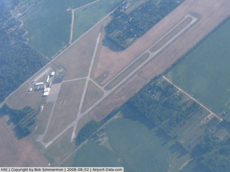
Three Rivers Municipal Dr Haines Airport |
|
 |
(Click on the photo to enlarge) |
Location & QuickFacts
| FAA Information Effective: | 2008-09-25 |
| Airport Identifier: | HAI |
| Airport Status: | Operational |
| Longitude/Latitude: | 085-35-36.2000W/41-57-35.1000N
-85.593389/41.959750 (Estimated) |
| Elevation: | 824 ft / 251.16 m (Estimated) |
| Land: | 305 acres |
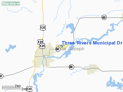
| From nearest city: | 2 nautical miles NE of Three Rivers, MI |
| Location: | St Joseph County, MI |
| Magnetic Variation: | 04W (2000) |
Owner & Manager
| Ownership: | Publicly owned |
| Owner: | City Of Three Rivers |
| Address: | Municipal Bldg, 333 West Michigan Ave.
Three Rivers, MI 49093 |
| Phone number: | 269-273-1075 |
| Manager: | Raymond Galovich Jr |
| Address: | City Of Three Rivers, 333 West Michigan Avenue
Three Rivers, MI 49093 |
| Phone number: | 269-506-3887 |
Airport Operations and Facilities
| Airport Use: | Open to public |
| Wind indicator: | Yes |
| Segmented Circle: | Yes |
| Control Tower: | No |
| Lighting Schedule: | DUSK-DAWN
MIRL RYS 09/27 & 05/23 & PAPI RY 09 & 27 PRESET LOW INTST DUSK-2200; AFTER 2200 ACTVT - CTAF. |
| Beacon Color: | Clear-Green (lighted land airport) |
| Landing fee charge: | No |
| Sectional chart: | Chicago |
| Region: | AGL - Great Lakes |
| Traffic Pattern Alt: | 1000 ft |
| Boundary ARTCC: | ZAU - Chicago |
| Tie-in FSS: | LAN - Lansing |
| FSS on Airport: | No |
| FSS Toll Free: | 1-800-WX-BRIEF |
| NOTAMs Facility: | LAN (NOTAM-d service avaliable) |
| Federal Agreements: | NGY |
Airport Communications
| CTAF: | 122.800 |
| Unicom: | 122.800 |
Airport Services
| Fuel available: | 100LLA |
| Airframe Repair: | MAJOR |
| Power Plant Repair: | MAJOR |
| Bottled Oxygen: | NONE |
| Bulk Oxygen: | NONE |
Runway Information
Runway 05/23
| Dimension: | 2729 x 60 ft / 831.8 x 18.3 m |
| Surface: | ASPH, Fair Condition |
| Weight Limit: | Single wheel: 16000 lbs. |
| Edge Lights: | Medium |
| |
Runway 05 |
Runway 23 |
| Longitude: | 085-35-43.3960W | 085-35-18.0730W |
| Latitude: | 41-57-21.6980N | 41-57-40.8030N |
| Elevation: | 822.00 ft | 821.00 ft |
| Alignment: | 45 | 127 |
| Traffic Pattern: | Left | Left |
| Markings: | Non-precision instrument, Good Condition | Non-precision instrument, Good Condition |
| Touchdown Lights: | No | No |
| Obstruction: | 15 ft road, 587.0 ft from runway, 25:1 slope to clear | 13 ft road, 320.0 ft from runway, 9:1 slope to clear |
|
Runway 09/27
| Dimension: | 4000 x 75 ft / 1219.2 x 22.9 m |
| Surface: | ASPH, Fair Condition |
| Weight Limit: | Single wheel: 26000 lbs.
Dual wheel: 30000 lbs. |
| Edge Lights: | Medium |
| |
Runway 09 |
Runway 27 |
| Longitude: | 085-36-04.4190W | 085-35-11.4740W |
| Latitude: | 41-57-37.5740N | 41-57-37.7640N |
| Elevation: | 820.00 ft | 822.00 ft |
| Alignment: | 90 | 127 |
| Traffic Pattern: | Left | Left |
| Markings: | Non-precision instrument, Good Condition | Non-precision instrument, Good Condition |
| Crossing Height: | 25.00 ft | 29.00 ft |
| VASI: | 4-light PAPI on left side | 4-light PAPI on left side |
| Visual Glide Angle: | 3.00° | 3.50° |
| Runway End Identifier: | Yes | Yes |
| Touchdown Lights: | No | No |
| Obstruction: | , 50:1 slope to clear | 62 ft trees, 1467.0 ft from runway, 20:1 slope to clear |
|
Radio Navigation Aids
| ID |
Type |
Name |
Ch |
Freq |
Var |
Dist |
| HAI | NDB | Three Rivers | | 407.00 | 02W | 0.1 nm |
| IRS | NDB | Sturgis | | 382.00 | 04W | 11.3 nm |
| ANQ | NDB | Angola | | 347.00 | 05W | 29.7 nm |
| BT | NDB | Batol | | 272.00 | 04W | 30.3 nm |
| OLK | VOR | Wolf Lake | | 110.40 | 03W | 43.1 nm |
| AZO | VOR/DME | Kalamazoo | 027X | 109.00 | 01W | 16.8 nm |
| ELX | VOR/DME | Keeler | 113X | 116.60 | 00E | 26.1 nm |
| LFD | VOR/DME | Litchfield | 049X | 111.20 | 05W | 37.5 nm |
| PMM | VOR/DME | Pullman | 058X | 112.10 | 00E | 38.0 nm |
| GRR | VOR/DME | Grand Rapids | 106Y | 115.95 | 04W | 49.9 nm |
| BTL | VORTAC | Battle Creek | 031X | 109.40 | 02W | 26.0 nm |
| GSH | VORTAC | Goshen | 084X | 113.70 | 00E | 32.6 nm |
| GIJ | VORTAC | Gipper | 101X | 115.40 | 00E | 34.4 nm |
Remarks
- POSSIBILITY OF CROP IRRIGATION EQUIP OPERG IN NE APCH TO RY 23.
- RY 23 15' VERTICAL CLNC OVER THE ROAD IS WAIVED BY FAA.
- RADIO CONTROLLED AIRPLANES OPERATE SOUTH OF APCH END RY 27.
- GCO AVBL ON FREQ 121.725 THRU AZO CD & FLT SVCS.
Images and information placed above are from
http://www.airport-data.com/airport/HAI/
We thank them for the data!
| General Info
|
| Country |
United States
|
| State |
MICHIGAN
|
| FAA ID |
HAI
|
| Latitude |
41-57-35.100N
|
| Longitude |
085-35-36.200W
|
| Elevation |
824 feet
|
| Near City |
THREE RIVERS
|
We don't guarantee the information is fresh and accurate. The data may
be wrong or outdated.
For more up-to-date information please refer to other sources.
|
|