 |
|
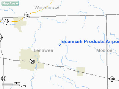
Tecumseh Products Airport |
|
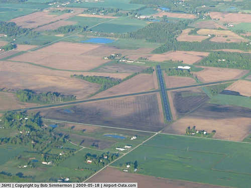 |
(Click on the photo to enlarge) |
|
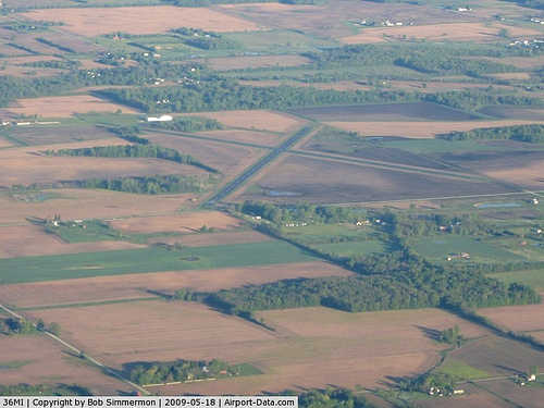 |
(Click on the photo to enlarge) |
Location & QuickFacts
| FAA Information Effective: | 2008-09-25 |
| Airport Identifier: | 36MI |
| Airport Status: | Operational |
| Longitude/Latitude: | 083-52-41.9000W/42-01-57.6000N
-83.878306/42.032667 (Estimated) |
| Elevation: | 795 ft / 242.32 m (Surveyed) |
| Land: | 0 acres |
| From nearest city: | 3 nautical miles NE of Tecumseh, MI |
| Location: | Lenawee County, MI |
| Magnetic Variation: | 06W (2000) |
Owner & Manager
| Ownership: | Privately owned |
| Owner: | Tecumseh Products Co. |
| Address: | 100 E. Patterson Street
Tecumseh, MI 49286 |
| Phone number: | 517-423-8678 |
| Manager: | Dennis Bailey |
| Address: | 100 E. Patterson Street
Tecumseh, MI 49286 |
| Phone number: | 517-423-8678 |
Airport Operations and Facilities
| Airport Use: | Private |
| Wind indicator: | Yes |
| Segmented Circle: | No |
| Control Tower: | No |
| Lighting Schedule: | PHONE REQ
RWY LGTS OPER BY CALLING 313-423-8678. |
| Landing fee charge: | No |
| Sectional chart: | Detroit |
| Region: | AGL - Great Lakes |
| Boundary ARTCC: | ZOB - Cleveland |
| Tie-in FSS: | LAN - Lansing |
| FSS on Airport: | No |
| FSS Toll Free: | 1-800-WX-BRIEF |
Airport Services
| Airframe Repair: | NONE |
| Power Plant Repair: | NONE |
Runway Information
Runway 06/24
| Dimension: | 4258 x 75 ft / 1297.8 x 22.9 m |
| Surface: | ASPH, |
| Edge Lights: | Medium |
| |
Runway 06 |
Runway 24 |
| Traffic Pattern: | Left | Left |
|
Runway 13/31
| Dimension: | 4278 x 75 ft / 1303.9 x 22.9 m |
| Surface: | ASPH, |
| Edge Lights: | Medium |
| |
Runway 13 |
Runway 31 |
| Traffic Pattern: | Left | Left |
|
Radio Navigation Aids
| ID |
Type |
Name |
Ch |
Freq |
Var |
Dist |
| TCU | NDB | Tecumseh | | 239.00 | 04W | 0.2 nm |
| ADG | NDB | Adrian | | 278.00 | 06W | 13.2 nm |
| USE | NDB | Fulton | | 375.00 | 05W | 27.9 nm |
| RYS | NDB | Grosse Ile | | 419.00 | 06W | 32.6 nm |
| OZW | NDB | Howell | | 243.00 | 05W | 36.5 nm |
| G | NDB | Golf | | 398.00 | 05W | 39.2 nm |
| BYN | NDB | Bryan | | 260.00 | 04W | 42.4 nm |
| VQ | NDB | Cargl | | 230.00 | 05W | 45.5 nm |
| QG | NDB | Windsor | | 353.00 | 06W | 48.0 nm |
| DFI | NDB | Defiance | | 246.00 | 05W | 48.7 nm |
| TOL | TACAN | Toledo | 072X | | 05W | 26.6 nm |
| DXO | VOR/DME | Detroit | 081X | 113.40 | 06W | 25.3 nm |
| JXN | VOR/DME | Jackson | 033X | 109.60 | 05W | 29.2 nm |
| VWV | VOR/DME | Waterville | 078X | 113.10 | 02W | 36.6 nm |
| LFD | VOR/DME | Litchfield | 049X | 111.20 | 05W | 39.6 nm |
| YQG | VOR/DME | Windsor | 085X | 113.80 | 06W | 48.6 nm |
| CRL | VORTAC | Carleton | 104X | 115.70 | 03W | 18.8 nm |
| SVM | VORTAC | Salem | 090X | 114.30 | 03W | 25.9 nm |
| PSI | VORTAC | Pontiac | 047X | 111.00 | 03W | 43.0 nm |
| YIP | VOT | Willow Run | | 112.00 | | 20.0 nm |
| DTW | VOT | Detroit Met Wayne | | 109.80 | | 25.7 nm |
| DET | VOT | Detroit City | | 111.60 | | 44.4 nm |
Remarks
- VASI ALL RYS.
- OWNER DESIRES ARPT NOT BE CHARTED.
- EXISTED PRIOR TO 1959.
Images and information placed above are from
http://www.airport-data.com/airport/36MI/
We thank them for the data!
| General Info
|
| Country |
United States
|
| State |
MICHIGAN
|
| FAA ID |
36MI
|
| Latitude |
42-01-57.600N
|
| Longitude |
083-52-41.900W
|
| Elevation |
795 feet
|
| Near City |
TECUMSEH
|
We don't guarantee the information is fresh and accurate. The data may
be wrong or outdated.
For more up-to-date information please refer to other sources.
|
|


