 |
|
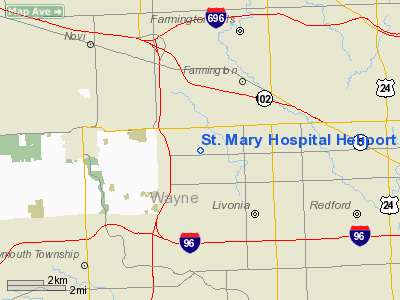
St. Mary Hospital Heliport |
Location & QuickFacts
| FAA Information Effective: | 2008-09-25 |
| Airport Identifier: | 2MI2 |
| Airport Status: | Operational |
| Longitude/Latitude: | 083-24-14.7610W/42-25-40.1280N
-83.404100/42.427813 (Estimated) |
| Elevation: | 665 ft / 202.69 m (Estimated) |
| Land: | 0 acres |
| From nearest city: | 0 nautical miles N of Livonia, MI |
| Location: | Wayne County, MI |
| Magnetic Variation: | 06W (1990) |
Owner & Manager
| Ownership: | Privately owned |
| Owner: | St. Mary Hospital |
| Address: | 36475 Five Mile Rd
Livonia, MI 48154 |
| Phone number: | 313-464-4800
EXT 2457. |
| Manager: | Clavio Gallerani
DIRECTOR OF SECURITY. |
| Address: | 36475 Five Mile Rd
Livonia, MI 48154 |
| Phone number: | 313-464-4800 |
Airport Operations and Facilities
| Airport Use: | Private
MEDICAL. |
| Wind indicator: | Yes |
| Segmented Circle: | No |
| Control Tower: | No |
| Sectional chart: | Detroit |
| Region: | AGL - Great Lakes |
| Boundary ARTCC: | ZOB - Cleveland |
| Tie-in FSS: | LAN - Lansing |
| FSS Toll Free: | 1-800-WX-BRIEF |
Runway Information
Helipad H1
| Dimension: | 20 x 20 ft / 6.1 x 6.1 m |
| Surface: | CONC, |
| |
Runway H1 |
Runway |
| Traffic Pattern: | Left | Left |
|
Radio Navigation Aids
| ID |
Type |
Name |
Ch |
Freq |
Var |
Dist |
| G | NDB | Golf | | 398.00 | 05W | 19.3 nm |
| VQ | NDB | Cargl | | 230.00 | 05W | 20.4 nm |
| RYS | NDB | Grosse Ile | | 419.00 | 06W | 22.6 nm |
| QG | NDB | Windsor | | 353.00 | 06W | 24.8 nm |
| OZW | NDB | Howell | | 243.00 | 05W | 28.7 nm |
| TCU | NDB | Tecumseh | | 239.00 | 04W | 31.7 nm |
| ADG | NDB | Adrian | | 278.00 | 06W | 45.0 nm |
| MTC | TACAN | Selfridge | 064X | | 06W | 27.7 nm |
| DXO | VOR/DME | Detroit | 081X | 113.40 | 06W | 13.0 nm |
| YQG | VOR/DME | Windsor | 085X | 113.80 | 06W | 27.7 nm |
| JXN | VOR/DME | Jackson | 033X | 109.60 | 05W | 47.9 nm |
| SVM | VORTAC | Salem | 090X | 114.30 | 03W | 8.5 nm |
| PSI | VORTAC | Pontiac | 047X | 111.00 | 03W | 17.4 nm |
| CRL | VORTAC | Carleton | 104X | 115.70 | 03W | 23.0 nm |
| FNT | VORTAC | Flint | 116X | 116.90 | 06W | 35.8 nm |
| DTW | VOT | Detroit Met Wayne | | 109.80 | | 12.1 nm |
| YIP | VOT | Willow Run | | 112.00 | | 12.8 nm |
| DET | VOT | Detroit City | | 111.60 | | 17.3 nm |
Remarks
- PRVDD APCH/DEP RTES OPS/FM 070 TO 100 & FM 260 TO 290; TKOF/LDG AREA MKD; WIND IND MAINTAINED; & FIRST ROW OF AUTO PARKING LOT SPACES TO THE E & TO THE W ARE REMOVED & THESE DESIGNATED AS NO PARKING AREAS.
Images and information placed above are from
http://www.airport-data.com/airport/2MI2/
We thank them for the data!
| General Info
|
| Country |
United States
|
| State |
MICHIGAN
|
| FAA ID |
2MI2
|
| Latitude |
42-25-40.128N
|
| Longitude |
083-24-14.761W
|
| Elevation |
665 feet
|
| Near City |
LIVONIA
|
We don't guarantee the information is fresh and accurate. The data may
be wrong or outdated.
For more up-to-date information please refer to other sources.
|
|


