 |
|
|
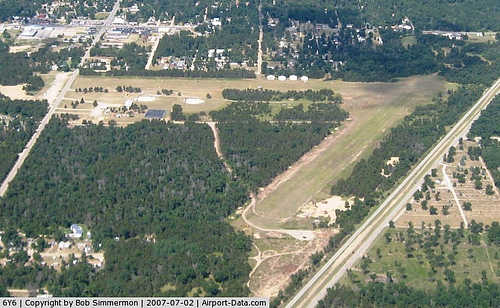 |
(Click on the photo to enlarge) |
|
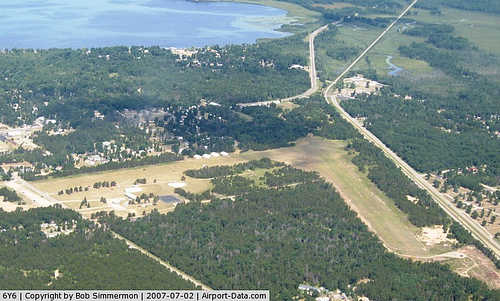 |
(Click on the photo to enlarge) |
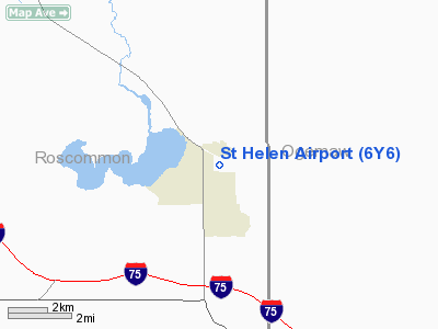
Location & QuickFacts
| FAA Information Effective: | 2008-09-25 |
| Airport Identifier: | 6Y6 |
| Airport Status: | Operational |
| Longitude/Latitude: | 084-24-00.0460W/44-22-00.0670N
-84.400013/44.366685 (Estimated) |
| Elevation: | 1198 ft / 365.15 m (Estimated) |
| Land: | 80 acres |
| From nearest city: | 1 nautical miles SE of St Helen, MI |
| Location: | Roscommon County, MI |
| Magnetic Variation: | 05W (1985) |
Owner & Manager
| Ownership: | Publicly owned |
| Owner: | Richfield Township |
| Address: | 1410 N St. Helen Rd
St. Helen, MI 48656 |
| Phone number: | 989-389-3213 |
| Manager: | Pending |
| Address: | Po Box 128
St. Helen, MI 48656 |
| Phone number: | 989-389-4062 |
Airport Operations and Facilities
| Airport Use: | Open to public |
| Wind indicator: | Yes |
| Segmented Circle: | Yes |
| Control Tower: | No |
| Landing fee charge: | No |
| Sectional chart: | Lake Huron |
| Region: | AGL - Great Lakes |
| Boundary ARTCC: | ZMP - Minneapolis |
| Tie-in FSS: | LAN - Lansing |
| FSS on Airport: | No |
| FSS Toll Free: | 1-800-WX-BRIEF |
| NOTAMs Facility: | LAN (NOTAM-d service avaliable) |
Airport Communications
Airport Services
| Airframe Repair: | NONE |
| Power Plant Repair: | NONE |
| Bottled Oxygen: | NONE |
| Bulk Oxygen: | NONE |
Runway Information
Runway 12/30
| Dimension: | 2600 x 120 ft / 792.5 x 36.6 m |
| Surface: | TURF, Fair Condition |
| |
Runway 12 |
Runway 30 |
| Longitude: | 084-24-09.4900W | 084-23-34.1800W |
| Latitude: | 44-22-05.8000N | 44-21-53.3000N |
| Elevation: | 1198.00 ft | 1198.00 ft |
| Traffic Pattern: | Left | Left |
| Displaced threshold: | 830.00 ft | 800.00 ft |
| Runway End Identifier: | No | No |
| Centerline Lights: | No | No |
| Touchdown Lights: | No | No |
| Obstruction: | 52 ft trees, 220.0 ft from runway, 30 ft right of centerline, 4:1 slope to clear
APCH RATIO 3:1 AT DSPLCD THLD OVER 25 FT TREE, 75 FT DSTC, 125 FT L. | 60 ft trees, 371.0 ft from runway, 6:1 slope to clear
RWY 30 APCH RATIO 20:1 AT DSPLCD THLD, +60' TREES 1257 FT DSTC, 60 FT R. |
|
Runway 18/36
| Dimension: | 2600 x 110 ft / 792.5 x 33.5 m |
| Surface: | TURF, Fair Condition |
| |
Runway 18 |
Runway 36 |
| Longitude: | 084-24-08.7900W | 084-24-08.7900W |
| Latitude: | 44-22-06.6200N | 44-21-41.2400N |
| Elevation: | 1198.00 ft | 1198.00 ft |
| Traffic Pattern: | Left | Left |
| Displaced threshold: | 825.00 ft | 620.00 ft |
| Runway End Identifier: | No | No |
| Centerline Lights: | No | No |
| Touchdown Lights: | No | No |
| Obstruction: | 28 ft trees, 95 ft left of centerline
APCH RATIO 20:1 OVER 72 FT TREES, 1440 FT DSTC, L/R. | 18 ft road, 40.0 ft from runway, 2:1 slope to clear
RWY 36 APCH RATIO 0:1 AT DSPLCD THLD OVER 35 FT TREES, 0 FT DSTC, 120 FT L. |
|
Radio Navigation Aids
| ID |
Type |
Name |
Ch |
Freq |
Var |
Dist |
| BHW | NDB | Hardwood | | 236.00 | 06W | 15.3 nm |
| GDW | NDB | Wiggins | | 209.00 | 04W | 24.1 nm |
| GYG | NDB | Grayling | | 359.00 | 06W | 29.4 nm |
| CAD | NDB | Cadillac | | 269.00 | 04W | 44.0 nm |
| CXK | NDB | Clam Lake | | 251.00 | 05W | 48.1 nm |
| TV | NDB | Gwenn | | 365.00 | 05W | 49.3 nm |
| CGG | VOR | Grayling | | 109.80 | 06W | 23.6 nm |
| HTL | VOR/DME | Houghton Lake | 053X | 111.60 | 05W | 11.4 nm |
| BXZ | VOR/DME | West Branch | 079X | 113.20 | 06W | 11.9 nm |
| GLR | VOR/DME | Gaylord | 029X | 109.20 | 06W | 40.9 nm |
| ASP | VOR/DME | Au Sable | 108X | 116.10 | 07W | 43.5 nm |
| MOP | VOR/DME | Mount Pleasant | 043X | 110.60 | 05W | 47.0 nm |
Remarks
- ARPT CLSD DEC THRU MAR & WHEN SNOW COVERED.
- HANGARS LOCATED 135 FT WEST OF CL RY 18/36.
Images and information placed above are from
http://www.airport-data.com/airport/6Y6/
We thank them for the data!
| General Info
|
| Country |
United States
|
| State |
MICHIGAN
|
| FAA ID |
6Y6
|
| Latitude |
44-22-00.067N
|
| Longitude |
084-24-00.046W
|
| Elevation |
1198 feet
|
| Near City |
ST HELEN
|
We don't guarantee the information is fresh and accurate. The data may
be wrong or outdated.
For more up-to-date information please refer to other sources.
|
|


