 |
|
Southwest Michigan Regional Airport |
| Southwest Michigan Regional Airport |
| IATA: BEH – ICAO: KBEH |
| Summary |
| Airport type |
Public |
| Operator |
Cities of Benton Harbor and St Joseph, Michigan |
| Location |
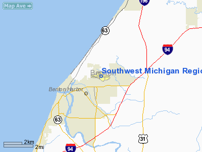
Benton Harbor, Michigan |
| Elevation AMSL |
643 ft / 196.0 m |
| Coordinates |
42°07′42.900″N 86°25′42.600″W / 42.128583°N 86.4285°W / 42.128583; -86.4285Coordinates: 42°07′42.900″N 86°25′42.600″W / 42.128583°N 86.4285°W / 42.128583; -86.4285 |
| Runways |
| Direction |
Length |
Surface |
| ft |
m |
| 9/27 |
5,109 |
1,557 |
Asphalt |
| 13/31 |
3,661 |
1,116 |
Asphalt |
| 18/36 |
2,498 |
762 |
Asphalt |
Southwest Michigan Regional Airport (IATA: BEH, ICAO: KBEH) is a public airport located in Benton Harbor in Berrien County, Michigan, USA. It was previously served from 1995-2000 by Mesaba Airlines, offering five daily flights to the Northwest Airlines hub at Detroit. But despite an intense local marketing campaign (utilizing the slogan You Can Get There From Here), the proximity of airports in Chicago, Kalamazoo and South Bend, Indiana siphoned business from BEH and service was discontinued. The airport has spent most of the current decade without commercial air service. It is used primarily by general aviation and corporate clients. Facilities
The airport is staffed as follows:
- Monday through Friday, May through September - 7AM to 8PM
- Monday through Friday, October through April - 7AM to 6PM
- Saturday and Sunday, Year round - 8AM to 5PM
Control Tower
Opened in 1973, the air traffic control tower sits abandoned to the present day after its closure during a 1981 controller strike. It ceased operation and never re-opened.
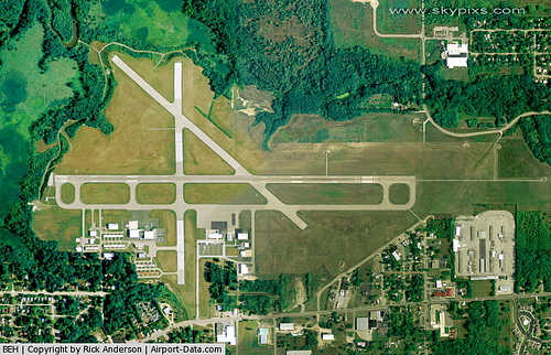
Runways
- Runway 9/27: 5,109 x 100 ft. (1,557 x 30 m), Surface: Asphalt
- Runway 13/31: 3,661 x 100 ft. (1,116 x 30 m), Surface: Asphalt
- Runway 18/36: 2,498 x 100 ft. (762 x 30 m), Surface: Asphalt
Transit
- The airport is accessible by road from Territorial Rd, and is close to I-94 and I-94 Business Loop.
The above content comes from Wikipedia and is published under free licenses – click here to read more.
|
 |
(Click on the photo to enlarge) |
Location & QuickFacts
| FAA Information Effective: | 2008-09-25 |
| Airport Identifier: | BEH |
| Airport Status: | Operational |
| Longitude/Latitude: | 086-25-42.6000W/42-07-42.9000N
-86.428500/42.128583 (Estimated) |
| Elevation: | 643 ft / 195.99 m (Surveyed) |
| Land: | 485 acres |
| From nearest city: | 2 nautical miles NE of Benton Harbor, MI |
| Location: | Berrien County, MI |
| Magnetic Variation: | 03W (1985) |
Owner & Manager
| Ownership: | Publicly owned |
| Owner: | Benton Harbor/st Joseph |
| Address: | 1123 Territorial Rd
Benton Harbor, MI 49022 |
| Phone number: | 269-927-3194 |
| Manager: | Robert Scherwitz |
| Address: | 1123 Territorial Rd
Benton Harbor, MI 49022 |
| Phone number: | 269-927-3194
EXT 10, OR 269-927-2643 MAINT OFC. |
Airport Operations and Facilities
| Airport Use: | Open to public |
| Wind indicator: | Yes |
| Segmented Circle: | Yes |
| Control Tower: | No |
| Lighting Schedule: | DUSK-DAWN
ACTVT HIRL RY 09/27; MIRL RYS 13/31 & 18/36; MALSR RY 27; REIL RYS 09 & 13 & 31 - CTAF. |
| Beacon Color: | Clear-Green (lighted land airport) |
| Landing fee charge: | Yes
LDG FEE FOR ALL MULTI-ENGINE & COML SINGLE ENGINE ACFT WAIVED WITH MIN FUEL PURCHASE. |
| Sectional chart: | Chicago |
| Region: | AGL - Great Lakes |
| Boundary ARTCC: | ZAU - Chicago |
| Tie-in FSS: | LAN - Lansing |
| FSS on Airport: | No |
| FSS Toll Free: | 1-800-WX-BRIEF |
| NOTAMs Facility: | BEH (NOTAM-d service avaliable) |
| Federal Agreements: | NGY |
Airport Communications
| CTAF: | 123.000 |
| Unicom: | 123.000 |
Airport Services
| Fuel available: | 100LLA1+
FOR SVC AFTER HRS CALL 269-325-7529. CALL-IN FEE. |
| Airframe Repair: | MAJOR |
| Power Plant Repair: | MAJOR |
| Bottled Oxygen: | HIGH |
Runway Information
Runway 09/27
| Dimension: | 5109 x 100 ft / 1557.2 x 30.5 m |
| Surface: | ASPH, Good Condition
RWY 18/38 PVMNT CRACKING |
| Surface Treatment: | Saw-cut or plastic Grooved |
| Weight Limit: | Single wheel: 28000 lbs.
Dual wheel: 35000 lbs. |
| Edge Lights: | High |
| |
Runway 09 |
Runway 27 |
| Longitude: | 086-26-12.5896W | 086-25-04.7949W |
| Latitude: | 42-07-40.5784N | 42-07-40.1806N |
| Elevation: | 627.00 ft | 643.00 ft |
| Alignment: | 90 | 127 |
| ILS Type: | | ILS
|
| Traffic Pattern: | Left | Left |
| Markings: | Precision instrument, Good Condition | Precision instrument, Good Condition
MARKING FADED |
| Crossing Height: | 44.00 ft | 3.00 ft |
| Displaced threshold: | 0.00 ft | 571.00 ft |
| VASI: | 4-box on left side | |
| Visual Glide Angle: | 3.00° | 0.00° |
| Approach lights: | | MALSR |
| Runway End Identifier: | Yes | |
| Obstruction: |
+ 38 FT LIGHTED ILS ANT, 152 FT FM RWY END, 300 FT R. | 51 ft trees, 1475.0 ft from runway, 600 ft right of centerline, 25:1 slope to clear
RWY 27 APCH RATIO 34:1 TO DSPLCD THLD
6 FT FENCE 480 FT L. |
|
Runway 13/31
| Dimension: | 3662 x 100 ft / 1116.2 x 30.5 m |
| Surface: | ASPH, Fair Condition
RWY 18/38 PVMNT CRACKING |
| Weight Limit: | Single wheel: 30000 lbs.
Dual wheel: 45000 lbs. |
| Edge Lights: | Medium |
| |
Runway 13 |
Runway 31 |
| Longitude: | 086-26-01.7232W | 086-25-25.4905W |
| Latitude: | 42-07-57.5948N | 42-07-33.4929N |
| Elevation: | 626.00 ft | 630.00 ft |
| Alignment: | 127 | 127 |
| Traffic Pattern: | Left | Left |
| Markings: | Basic, Poor Condition | Basic, Poor Condition
MARKING FADED |
| Crossing Height: | 45.00 ft | 41.00 ft |
| VASI: | 4-box on left side | 4-box on left side |
| Visual Glide Angle: | 3.50° | 4.00° |
| Runway End Identifier: | Yes | Yes |
| Obstruction: | , 20:1 slope to clear | 50 ft trees, 1100.0 ft from runway, 120 ft left of centerline, 18:1 slope to clear |
|
Runway 18/36
| Dimension: | 2498 x 100 ft / 761.4 x 30.5 m |
| Surface: | ASPH, Poor Condition
RWY 18/38 PVMNT CRACKING |
| Weight Limit: | Single wheel: 16000 lbs. |
| Edge Lights: | Medium |
| |
Runway 18 |
Runway 36 |
| Longitude: | 086-25-49.4567W | 086-25-49.1310W |
| Latitude: | 42-07-56.7160N | 42-07-32.0426N |
| Elevation: | 629.00 ft | 625.00 ft |
| Alignment: | 127 | 127 |
| Traffic Pattern: | Left | Left |
| Markings: | Basic, Poor Condition
MARKING FADED | Basic, Poor Condition |
|
Radio Navigation Aids
| ID |
Type |
Name |
Ch |
Freq |
Var |
Dist |
| MGC | NDB | Michigan City | | 203.00 | 01W | 30.7 nm |
| HAI | NDB | Three Rivers | | 407.00 | 02W | 38.7 nm |
| IUL | NDB | La Porte | | 356.00 | 03W | 40.9 nm |
| HLM | NDB | Holland | | 233.00 | 03W | 41.9 nm |
| VP | NDB | Sedly | | 212.00 | 02W | 45.4 nm |
| IRS | NDB | Sturgis | | 382.00 | 04W | 48.3 nm |
| ELX | VOR/DME | Keeler | 113X | 116.60 | 00E | 13.7 nm |
| PMM | VOR/DME | Pullman | 058X | 112.10 | 00E | 24.9 nm |
| AZO | VOR/DME | Kalamazoo | 027X | 109.00 | 01W | 39.5 nm |
| OXI | VOR/DME | Knox | 103X | 115.60 | 00E | 49.5 nm |
| GIJ | VORTAC | Gipper | 101X | 115.40 | 00E | 22.2 nm |
| GSH | VORTAC | Goshen | 084X | 113.70 | 00E | 40.5 nm |
Remarks
- BIRDS AND DEER ON & INVOF ARPT.
- RWYS 13 & 18: DROP OFF BEGINS 90'FM PAVED SFC; RWY 9: DROP OFF BEGINS 110'FM THR.
- SNOW REMOVAL OPNS IN PROGRESS WINTER MONTHS; VEHICLE OPERATORS WILL BE MONITORING CTAF. ACFT LANDING/DEPARTING BENTON HARBOR SHOULD ANNOUNCE THEIR INTENTIONS ON CTAF.
Images and information placed above are from
http://www.airport-data.com/airport/BEH/
We thank them for the data!
| General Info
|
| Country |
United States
|
| State |
MICHIGAN
|
| FAA ID |
BEH
|
| Latitude |
42-07-42.900N
|
| Longitude |
086-25-42.600W
|
| Elevation |
643 feet
|
| Near City |
BENTON HARBOR
|
We don't guarantee the information is fresh and accurate. The data may
be wrong or outdated.
For more up-to-date information please refer to other sources.
|
|


