 |
|
Shamrock Field is a Gaelic Athletic Association stadium in St. John's, Newfoundland and Labrador, Canada. It was built in 1838 it has a capacity of 4,000. It is also sometimes used as the national stadium of Canada GAA
The above content comes from Wikipedia and is published under free licenses – click here to read more.
|
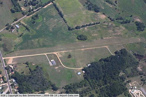 |
(Click on the photo to enlarge) |
|
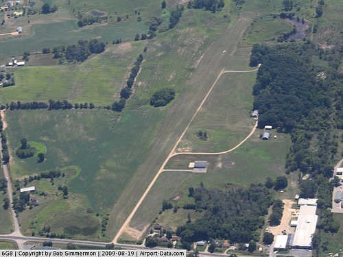 |
(Click on the photo to enlarge) |
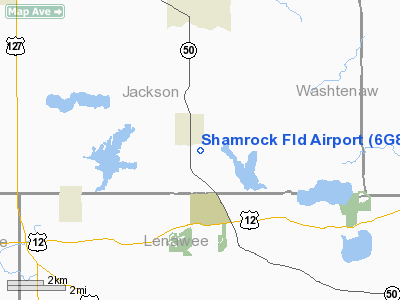
Location & QuickFacts
| FAA Information Effective: | 2008-09-25 |
| Airport Identifier: | 6G8 |
| Airport Status: | Operational |
| Longitude/Latitude: | 084-14-26.8120W/42-05-42.1480N
-84.240781/42.095041 (Estimated) |
| Elevation: | 995 ft / 303.28 m (Estimated) |
| Land: | 59 acres |
| From nearest city: | 1 nautical miles SE of Brooklyn, MI |
| Location: | Jackson County, MI |
| Magnetic Variation: | 05W (1985) |
Owner & Manager
| Ownership: | Privately owned |
| Owner: | Marcia Hubbs |
| Address: | 9237 Wamplers Lake Rd
Brooklyn, MI 49230 |
| Phone number: | 517-592-6253 |
| Manager: | Marcia Hubbs |
| Address: | 9237 Wamplers Lake Rd
Brooklyn, MI 49230 |
| Phone number: | 517-592-6253 |
Airport Operations and Facilities
| Airport Use: | Open to public |
| Wind indicator: | Yes |
| Segmented Circle: | Yes |
| Control Tower: | No |
| Lighting Schedule: | RDO-CTL
ACTVT LIRL RY 01/19 - CTAF. |
| Landing fee charge: | No |
| Sectional chart: | Detroit |
| Region: | AGL - Great Lakes |
| Boundary ARTCC: | ZOB - Cleveland |
| Tie-in FSS: | LAN - Lansing |
| FSS Toll Free: | 1-800-WX-BRIEF |
| NOTAMs Facility: | LAN (NOTAM-d service avaliable) |
Airport Communications
Airport Services
| Fuel available: | 100LL |
| Airframe Repair: | MAJOR |
| Power Plant Repair: | MAJOR |
Runway Information
Runway 01/19
| Dimension: | 2822 x 100 ft / 860.1 x 30.5 m |
| Surface: | TURF, Good Condition |
| Edge Lights: | Low |
| |
Runway 01 |
Runway 19 |
| Longitude: | 084-14-30.0300W | 084-14-23.5800W |
| Latitude: | 42-05-28.5100N | 42-05-55.7600N |
| Elevation: | 995.00 ft | 995.00 ft |
| Traffic Pattern: | Right | Left |
| Displaced threshold: | 0.00 ft | 613.00 ft |
| Obstruction: | 35 ft tree, 875.0 ft from runway, 25:1 slope to clear | 105 ft pline, 1494.0 ft from runway, 14:1 slope to clear
APCH RATIO 20:1 AT DSPLCD THR. |
|
Radio Navigation Aids
| ID |
Type |
Name |
Ch |
Freq |
Var |
Dist |
| ADG | NDB | Adrian | | 278.00 | 06W | 15.4 nm |
| TCU | NDB | Tecumseh | | 239.00 | 04W | 16.5 nm |
| USE | NDB | Fulton | | 375.00 | 05W | 29.6 nm |
| OZW | NDB | Howell | | 243.00 | 05W | 34.3 nm |
| BYN | NDB | Bryan | | 260.00 | 04W | 38.3 nm |
| BT | NDB | Batol | | 272.00 | 04W | 45.0 nm |
| DFI | NDB | Defiance | | 246.00 | 05W | 46.5 nm |
| ANQ | NDB | Angola | | 347.00 | 05W | 46.7 nm |
| RYS | NDB | Grosse Ile | | 419.00 | 06W | 48.5 nm |
| TOL | TACAN | Toledo | 072X | | 05W | 36.0 nm |
| JXN | VOR/DME | Jackson | 033X | 109.60 | 05W | 13.8 nm |
| LFD | VOR/DME | Litchfield | 049X | 111.20 | 05W | 23.5 nm |
| DXO | VOR/DME | Detroit | 081X | 113.40 | 06W | 39.6 nm |
| VWV | VOR/DME | Waterville | 078X | 113.10 | 02W | 47.2 nm |
| SVM | VORTAC | Salem | 090X | 114.30 | 03W | 34.4 nm |
| CRL | VORTAC | Carleton | 104X | 115.70 | 03W | 35.1 nm |
| LAN | VORTAC | Lansing | 045X | 110.80 | 05W | 42.6 nm |
| BTL | VORTAC | Battle Creek | 031X | 109.40 | 02W | 46.9 nm |
| PSI | VORTAC | Pontiac | 047X | 111.00 | 03W | 48.1 nm |
| YIP | VOT | Willow Run | | 112.00 | | 33.1 nm |
| DTW | VOT | Detroit Met Wayne | | 109.80 | | 39.8 nm |
Remarks
- 105 FT UNLIGHTED PLINE AND TOWER, 1/4 MILE FM THLD, EXTDD L & R OF CNTRLN RY 19.
- DEER ON & INVOF OF ARPT.
- ALL TFC PTNS CONDD EAST OF RWY 1/19.
Images and information placed above are from
http://www.airport-data.com/airport/6G8/
We thank them for the data!
| General Info
|
| Country |
United States
|
| State |
MICHIGAN
|
| FAA ID |
6G8
|
| Latitude |
42-05-42.148N
|
| Longitude |
084-14-26.812W
|
| Elevation |
995 feet
|
| Near City |
BROOKLYN
|
We don't guarantee the information is fresh and accurate. The data may
be wrong or outdated.
For more up-to-date information please refer to other sources.
|
|


