 |
|
Sawyer International Airport |
| Sawyer International Airport |
IATA: MQT – ICAO: KSAW – FAA LID: SAW

+
Sawyer
International
Airport
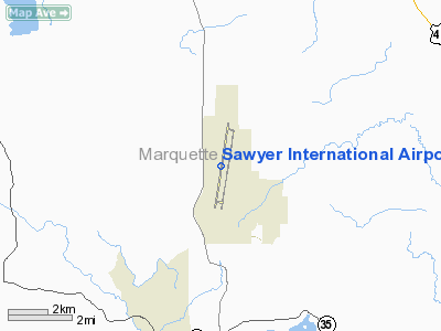
Location of airport in Michigan
|
| Summary |
| Airport type |
Public |
| Owner |
Marquette County |
| Serves |
Marquette, Michigan |
| Location |
Gwinn, Michigan |
| Elevation AMSL |
1,221 ft / 372 m |
| Coordinates |
46°21′13″N 087°23′43″W / 46.35361°N 87.39528°W / 46.35361; -87.39528 |
| Website |
www.sawyerairport.com |
| Runways |
| Direction |
Length |
Surface |
| ft |
m |
| 1/19 |
12,370 |
3,770 |
Asphalt/Concrete |
| Statistics (2009) |
| Total Passengers |
107,353 |
| Total Enplanements |
53,649 |
| Aircraft operations |
22,515 |
| Based aircraft |
44 |
| Source: FAA, Michigan DOT |
Sawyer International Airport (IATA: MQT, ICAO: KSAW, FAA LID: SAW) is a public airport located 17 miles (27 km) south of the central business district of Marquette, a city in Marquette County, Michigan, United States. The airport is publicly owned by Marquette County.
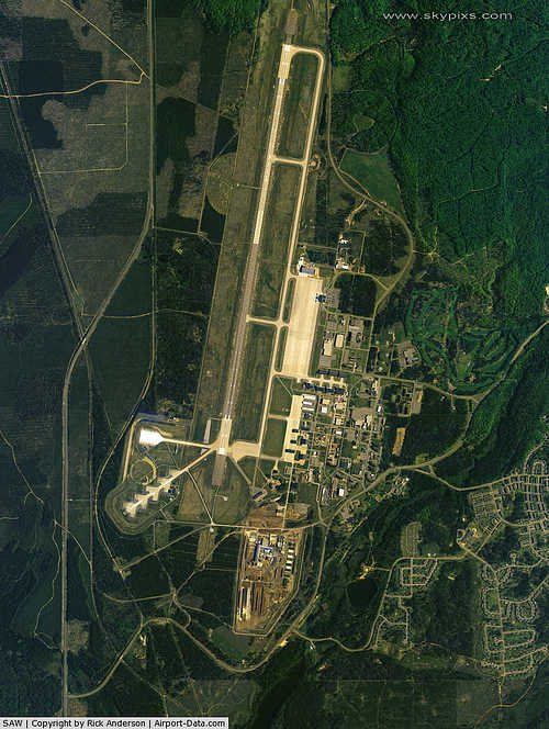
This commercial and general aviation airport is located near Gwinn, Michigan on a portion of the former K.I. Sawyer AFB, which closed in September 1995. The airport opened for passenger service in September 1999, serving Marquette and the surrounding area. It replaced the former Marquette County Airport (IATA: MQT, ICAO: KMQT, FAA LID: MQT) which closed the same year.
Although most U.S. airports use the same three-letter location identifier for the FAA and IATA, Sawyer International is assigned SAW by the FAA and MQT by the IATA (which had previously assigned SAW to Sabiha Gökçen International Airport in Istanbul, Turkey). The airport's ICAO identifier is KSAW. Facilities and aircraft
Sawyer International Airport covers an area of 2,100 acres (850 ha). It has a single asphalt/concrete runway, 12,370 x 150 ft (3,770 x 46 m), originally designed for B-52 bombers.
For 12-month period ending December 31, 2008, the airport had 22,515 aircraft operations, an average of 62 per day: 49% general aviation (10,940), 47% air taxi (10,536), <1% scheduled commercial (8), and 5% military (1,031). There are 44 aircraft based at this airport: 91% single engine (40) and 9% multi engine (4).
There is an industrial park, the Telkite Technology Park, adjacent to the airport, with 1,000 acres (4.0 km) of land and 1,500,000 square feet (139,000 m) of space in a Michigan Renaissance Zone, which exempts the tenant or owner from the majority of state and local taxes.
Airlines and destinations
| Airlines |
Destinations |
| American Eagle |
Chicago-O'Hare, Green Bay, Traverse City |
| Delta Connection operated by Mesaba Airlines |
Detroit, Minneapolis/St. Paul |
The above content comes from Wikipedia and is published under free licenses – click here to read more.
|
 |
(Click on the photo to enlarge) |
Location & QuickFacts
| FAA Information Effective: | 2008-09-25 |
| Airport Identifier: | SAW |
| Airport Status: | Operational |
| Longitude/Latitude: | 087-23-43.3000W/46-21-13.1000N
-87.395361/46.353639 (Estimated) |
| Elevation: | 1221 ft / 372.16 m (Surveyed) |
| Land: | 2100 acres |
| From nearest city: | 17 nautical miles S of Marquette, MI |
| Location: | Marquette County, MI |
| Magnetic Variation: | 04W (2000) |
Owner & Manager
| Ownership: | Publicly owned |
| Owner: | Marquette County |
| Address: | 125 G Avenue
Gwinn, MI 49841 |
| Phone number: | 906-346-3308 |
| Manager: | Keith Kaspari |
| Address: | Sawyer Intl Airport, 225 Airport Dr
Gwinn, MI 49841 |
| Phone number: | 906-346-3308 |
Airport Operations and Facilities
| Airport Use: | Open to public |
| Wind indicator: | Yes |
| Segmented Circle: | Yes |
| Control Tower: | Yes |
| Lighting Schedule: | DUSK-DAWN
ALL LIGHTING PILOT CONTROLLED CTAF 119.975 WHEN ATCT CLSD. |
| Beacon Color: | Clear-Green (lighted land airport) |
| Landing fee charge: | Yes
RAMP FEES IN EFFECT. LDG/RAMP FEES MAY BE WAIVED WITH FUEL PURCHASE. |
| Sectional chart: | Green Bay |
| Region: | AGL - Great Lakes |
| Boundary ARTCC: | ZMP - Minneapolis |
| Tie-in FSS: | GRB - Green Bay |
| FSS on Airport: | No |
| FSS Toll Free: | 1-800-WX-BRIEF |
| NOTAMs Facility: | SAW (NOTAM-d service avaliable) |
| Certification type/date: | I A S 09/1999
48 HRS PRIOR TO UNSKED ACR OPNS WITH MORE THAN 30 PSGR SEATS CALL AMGR 906-458-6636. |
| Federal Agreements: | NGYP |
Airport Communications
| CTAF: | 119.975 |
| Unicom: | 122.700 |
Airport Services
| Fuel available: | 100LLA
FUEL AVBL 24 HRS WITH CREDIT CARD, MULTI-SVC & AVCARD. SELF SERVICE FUEL LOCATED ADJACENT FBO RAMP. |
| Airframe Repair: | MAJOR |
| Power Plant Repair: | MAJOR |
| Bottled Oxygen: | NONE |
| Bulk Oxygen: | HIGH/LOW |
Runway Information
Runway 01/19
| Dimension: | 12366 x 150 ft / 3769.2 x 45.7 m
75 FT PAVED SHOULDERS EACH SIDE. |
| Surface: | ASPH-CONC, Fair Condition |
| Surface Treatment: | Saw-cut or plastic Grooved |
| Weight Limit: | Single wheel: 75000 lbs.
Dual wheel: 175000 lbs.
Dual tandem wheel: 490000 lbs. |
| Edge Lights: | High |
| |
Runway 01 |
Runway 19 |
| Longitude: | 087-23-56.9982W | 087-23-29.5411W |
| Latitude: | 46-20-12.7777N | 46-22-13.3696N |
| Elevation: | 1178.00 ft | 1221.00 ft |
| Alignment: | 9 | 127 |
| ILS Type: | ILS
| |
| Traffic Pattern: | Left | Left |
| Markings: | Precision instrument, Good Condition | Precision instrument, Good Condition |
| Crossing Height: | 66.00 ft | 62.00 ft |
| VASI: | 4-light PAPI on left side | 4-light PAPI on left side |
| Visual Glide Angle: | 3.00° | 3.00° |
| Approach lights: | MALSR | |
| Runway End Identifier: | | Yes
OTS INDEFLY. |
| Centerline Lights: | No | No |
|
Radio Navigation Aids
| ID |
Type |
Name |
Ch |
Freq |
Var |
Dist |
| SAW | VOR/DME | Sawyer | 118X | 117.10 | 04W | 0.3 nm |
| MQT | VOR/DME | Marquette/dcmsnd | 114X | 116.70 | 02W | 13.2 nm |
| ESC | VOR/DME | Escanaba | 045X | 110.80 | 00E | 40.0 nm |
| IMT | VOR/DME | Iron Mountain | 049X | 111.20 | 02W | 44.0 nm |
Remarks
- BIRDS & DEER ON & INVOF ARPT.
- FBO SERVICE AFTER HOURS CONTACT 906-222-3062.
- ARFF INDEX B AVBL. CALL ARPT MGR AT 906-458-6636 TO CONFIRM AVAILABILITY OF PSNL AND EQUIP.
- NORTH ENTRANCE TO AIRCARRIER RAMP, SOUTH OF ARFF/SRE BUILDING, CLSD NOV-MAR.
- GA & CHARTER ACFT PARKING AVBL AT GA TERMINAL ONLY, LCTD SE CORNER OF ARPT.
- S HALF OF ACR TERMINAL RAMP NOT PLOWED OCT-APR.
- FREQUENT SNOW REMOVAL OPNS IN PROGRESS VARIOUS TIMES OCT-APR. MONITOR CTAF.
- PAEW ON ARPT MONITOR 119.975 (CTAF).
- NO OBJECTIONS
Images and information placed above are from
http://www.airport-data.com/airport/SAW/
We thank them for the data!
| General Info
|
| Country |
United States
|
| State |
MICHIGAN
|
| FAA ID |
SAW
|
| Latitude |
46-21-13.000N
|
| Longitude |
087-23-44.996W
|
| Elevation |
1221 feet
|
| Near City |
MARQUETTE
|
We don't guarantee the information is fresh and accurate. The data may
be wrong or outdated.
For more up-to-date information please refer to other sources.
|
|


