|
|
Sault Ste Marie Muni / Sanderson Field Airport |
Sault Ste. Marie Municipal Airport
Sanderson Field |
| IATA: none – ICAO: KANJ – FAA LID: ANJ |
| Summary |
| Airport type |
Public |
| Owner |
City of Sault Saint Marie |
| Serves |
Sault Ste. Marie, Michigan |
| Elevation AMSL |
716 ft / 218 m |
| Coordinates |
46°28′45″N 084°22′06″W / 46.47917°N 84.36833°W / 46.47917; -84.36833 |
| Runways |
| Direction |
Length |
Surface |
| ft |
m |
| 14/32 |
5,234 |
1,595 |
Asphalt |
| Statistics (2008) |
| Aircraft operations |
9,067 |
| Based aircraft |
9 |
| Source: Federal Aviation Administration |
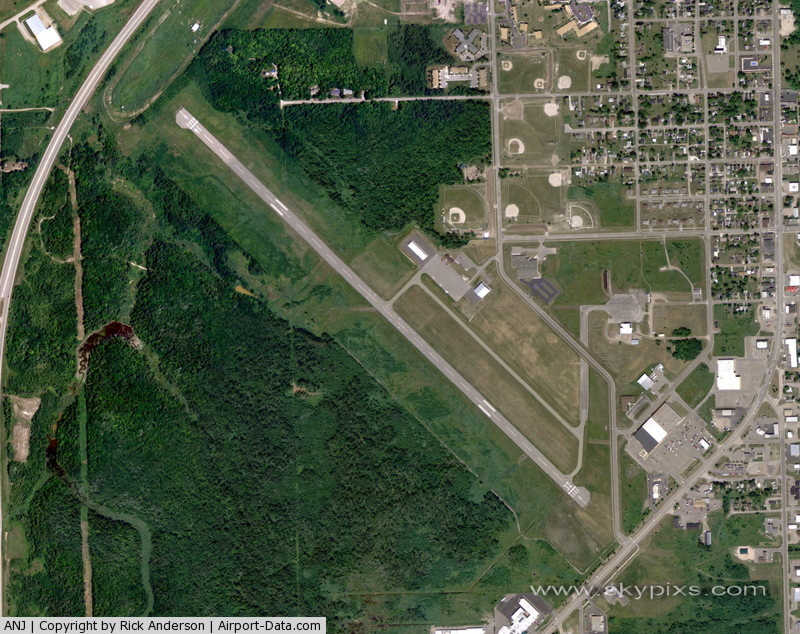
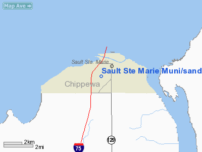
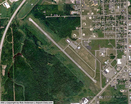
Sault Ste. Marie Municipal Airport (ICAO: KANJ, FAA LID: ANJ), also known as Sanderson Field, is a city-owned public-use airport located one nautical mile (1.85 km) southwest of the central business district of Sault Ste. Marie, a city in Chippewa County, Michigan, United States.
Although most U.S. airports use the same three-letter location identifier for the FAA and IATA, this airport is assigned ANJ by the FAA but has no designation from the IATA (which assigned ANJ to Zanaga Airport in Zanaga, Republic of Congo).
Facilities and aircraft
Sault Ste. Marie Municipal Airport covers an area of 400 acres (162 ha) at an elevation of 716 feet (218 m) above mean sea level. It has one runway designated 14/32 with an asphalt surface measuring 5,234 by 100 feet (1,595 x 30 m).
For the 12-month period ending December 31, 2008, the airport had 9,067 general aviation aircraft operations, an average of 24 per day. At that time there were 9 single-engine aircraft based at this airport.
The above content comes from Wikipedia and is published under free licenses – click here to read more.
|
 |
(Click on the photo to enlarge) |
Location & QuickFacts
| FAA Information Effective: | 2008-09-25 |
| Airport Identifier: | ANJ |
| Airport Status: | Operational |
| Longitude/Latitude: | 084-22-06.2000W/46-28-45.2000N
-84.368389/46.479222 (Estimated) |
| Elevation: | 716 ft / 218.24 m (Surveyed) |
| Land: | 400 acres |
| From nearest city: | 1 nautical miles SW of Sault Ste Marie, MI |
| Location: | Chippewa County, MI |
| Magnetic Variation: | 07W (1990) |
Owner & Manager
| Ownership: | Publicly owned |
| Owner: | City Of Sault Saint Marie |
| Address: | 325 Court St
Sault Ste. Marie, MI 49783 |
| Phone number: | 906-635-5261 |
| Manager: | Darien M. Neveu |
| Address: | 325 Court St
Sault Ste. Marie, MI 49783 |
| Phone number: | 906-632-5700 |
Airport Operations and Facilities
| Airport Use: | Open to public |
| Wind indicator: | Yes |
| Segmented Circle: | Yes |
| Control Tower: | No |
| Lighting Schedule: | RDO-CTL
ACTVT MIRL RY 14/32, PAPI RYS 14 & 32 & REIL RYS 14 & 32 - CTAF - 122.7 |
| Landing fee charge: | No |
| Sectional chart: | Lake Huron |
| Region: | AGL - Great Lakes |
| Boundary ARTCC: | ZMP - Minneapolis |
| Responsible ARTCC: | ZYZ - Toronto |
| Tie-in FSS: | GRB - Green Bay |
| FSS on Airport: | No |
| FSS Toll Free: | 1-800-WX-BRIEF |
| NOTAMs Facility: | ANJ (NOTAM-d service avaliable) |
Airport Communications
| CTAF: | 122.700 |
| Unicom: | 122.700 |
Airport Services
| Fuel available: | 100LLA
FUEL AFT HRS SELF SVC WITH CREDIT CARD. |
Runway Information
Runway 14/32
| Dimension: | 5234 x 100 ft / 1595.3 x 30.5 m |
| Surface: | ASPH, Good Condition |
| Edge Lights: | Medium |
| |
Runway 14 |
Runway 32 |
| Longitude: | 084-22-32.2733W | 084-21-40.2137W |
| Latitude: | 46-29-03.7232N | 46-28-26.6279N |
| Elevation: | 696.00 ft | 716.00 ft |
| Alignment: | 127 | 127 |
| Traffic Pattern: | Left | Right |
| Markings: | Basic, Fair Condition | Basic, Good Condition |
| Crossing Height: | 40.00 ft | 29.00 ft |
| Displaced threshold: | 180.00 ft | 178.00 ft |
| VASI: | 2-light PAPI on left side | 2-light PAPI on left side |
| Visual Glide Angle: | 3.00° | 3.00° |
| Runway End Identifier: | Yes | Yes |
| Obstruction: | , 50:1 slope to clear
APCH RATIO 50:1 TO DSPLCD THLD.
RWY 14 +5 FT FENCE; 130 FT DSTC. | 13 ft road, 201.0 ft from runway, 200 ft right of centerline
APCH RATIO 34:1 TO DSPLCD THLD. OVR +20 FT POLE 50 FT L 680 FT FM DSPLCD THLD.
+6 FT FENCE 201 FT DSTC 126 FT R. |
|
Radio Navigation Aids
| ID |
Type |
Name |
Ch |
Freq |
Var |
Dist |
| A | NDB | Gros Cap | | 286.00 | 06W | 10.4 nm |
| CI | NDB | Koloe | | 400.00 | 06W | 11.4 nm |
| DRM | NDB | Drummond Island | | 218.00 | 07W | 38.5 nm |
| SSM | VOR/DME | Sault Ste Marie | 059X | 112.20 | 04W | 4.6 nm |
| ERY | VOR/DME | Newberry | 019X | 108.20 | 06W | 46.5 nm |
Remarks
- US CUSTOMS ON REQ CALL 906-632-2631.
- DEER & BIRDS ON & INVOF ARPT.
- PILOTS OPERATING IN CANADIAN/US CLASS D AIRSPACE ARE REQUIRED TO ESTABLISH & MAINTAIN TWO-WAY COMMUNICATION & OBTAIN ATC CLNC FM SAULT ST MARIE ATCT (SOO TWR 118.8) PRIOR TO OPERATING IN THE CLASS D AIRSPACE. TRAFFIC ADVISORY SVC (118.8) IS AVBL IN THE US CLASS E SFC EXTENSION 0700-2000.
- GCO AVBL ON FREQ 135.075 THRU GRB AFSS.
- 50 FT DROP OFF, NORTH END, 200 FT FROM RY END.
- NO SNOW REMOVAL AFTER ATTENDED HRS EXCEPT FOR EMERGENCIES UPON REQUEST CALL CENTRAL DISPATCH 906-495-3312.
- E111: PRVDD OBSTNS WHICH PENETRATE 20:1 APCH SFC BE REMOVED/LOWERED OR THRS DSPLCD & MKD TO PRVD UNOBSTD 20:1 RWY APCH SFC; VFR USE ONLY; ALL OTHER... E111 CONT'D: RWY SFCS EXCEPT RWY 14/32 BE CLEARLY MKD CLSD; ARPT MGR ISSUES APROP NOTICES & INSURES ARPT....
Images and information placed above are from
http://www.airport-data.com/airport/ANJ/
We thank them for the data!
| General Info
|
| Country |
United States
|
| State |
MICHIGAN
|
| FAA ID |
ANJ
|
| Latitude |
46-28-45.145N
|
| Longitude |
084-22-06.276W
|
| Elevation |
716 feet
|
| Near City |
SAULT STE MARIE
|
We don't guarantee the information is fresh and accurate. The data may
be wrong or outdated.
For more up-to-date information please refer to other sources.
|
|