 |
|
| Romeo State Airport |
| IATA: none – ICAO: none – FAA LID: D98 |
| Summary |
| Airport type |
Public |
| Operator |
State of Michigan |
| Location |
Romeo, Michigan |
| Elevation AMSL |
739 ft / 225 m |
| Coordinates |
42°48′18″N 82°58′45″W / 42.805°N 82.97917°W / 42.805; -82.97917Coordinates: 42°48′18″N 82°58′45″W / 42.805°N 82.97917°W / 42.805; -82.97917 |
| Runways |
| Direction |
Length |
Surface |
| ft |
m |
| 18/36 |
4000 |
1219 |
Asphalt |
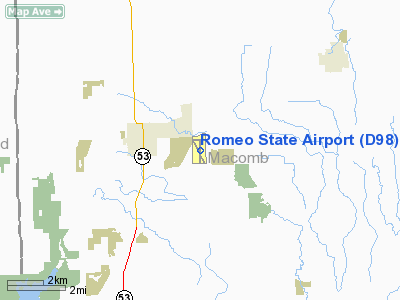
Romeo State Airport (FAA LID: D98) is a public airport owned and operated by the State of Michigan located 2m (3.2 km) east of Romeo, Michigan, United States. The airport in uncontrolled, and is used for general aviation purposes.
The airport has a single runway, runway 18/36. Previously, the airport had an additional runway, runway 15/33. This runway is currently closed and unusable.
On average, 76 aircraft operations occur each day, and 100% of the operations are general aviation. No commercial airline service is available. 63 aircraft are based on the field.
The above content comes from Wikipedia and is published under free licenses – click here to read more.
Location & QuickFacts
| FAA Information Effective: | 2008-09-25 |
| Airport Identifier: | D98 |
| Airport Status: | Operational |
| Longitude/Latitude: | 082-58-27.3360W/42-47-46.8030N
-82.974260/42.796334 (Estimated) |
| Elevation: | 739 ft / 225.25 m (Surveyed) |
| Land: | 265 acres |
| From nearest city: | 2 nautical miles E of Romeo, MI |
| Location: | Macomb County, MI |
| Magnetic Variation: | 06W (1985) |
Owner & Manager
| Ownership: | Publicly owned |
| Owner: | State Of Michigan |
| Address: | 2700 E Airport Service Dr
Lansing, MI 48906 |
| Phone number: | 517-335-9681 |
| Manager: | William H Decker |
| Address: | 15340 32 Mile Rd.
Ray, MI 48096 |
| Phone number: | 586-336-9116 |
Airport Operations and Facilities
| Airport Use: | Open to public |
| Wind indicator: | Yes |
| Segmented Circle: | No |
| Control Tower: | No |
| Lighting Schedule: | DUSK-DAWN
ACTVT MIRL, PAPI RYS 18 & 36, REIL RYS 18 & 36 CTAF. |
| Beacon Color: | Clear-Green (lighted land airport) |
| Landing fee charge: | No |
| Sectional chart: | Detroit |
| Region: | AGL - Great Lakes |
| Boundary ARTCC: | ZOB - Cleveland |
| Tie-in FSS: | LAN - Lansing |
| FSS on Airport: | No |
| FSS Toll Free: | 1-800-WX-BRIEF |
| NOTAMs Facility: | LAN (NOTAM-d service avaliable) |
| Federal Agreements: | N |
Airport Communications
| CTAF: | 122.800 |
| Unicom: | 122.800 |
Airport Services
| Fuel available: | 100LLA |
| Airframe Repair: | MAJOR |
| Power Plant Repair: | MAJOR |
| Bottled Oxygen: | NONE |
| Bulk Oxygen: | NONE |
Runway Information
Runway 18/36
| Dimension: | 4000 x 75 ft / 1219.2 x 22.9 m |
| Surface: | ASPH, Good Condition |
| Edge Lights: | Medium |
| |
Runway 18 |
Runway 36 |
| Longitude: | 082-58-28.4650W | 082-58-26.2080W |
| Latitude: | 42-48-06.5400N | 42-47-27.0650N |
| Elevation: | 739.00 ft | 729.00 ft |
| Alignment: | 127 | 127 |
| Traffic Pattern: | Left | Left |
| Markings: | Non-precision instrument, Good Condition | Non-precision instrument, Good Condition |
| Crossing Height: | 20.00 ft | 22.00 ft |
| Displaced threshold: | 470.00 ft | 0.00 ft |
| VASI: | 4-light PAPI on left side | 4-light PAPI on left side |
| Visual Glide Angle: | 3.00° | 3.00° |
| Runway End Identifier: | Yes | Yes |
| Centerline Lights: | No | No |
| Touchdown Lights: | No | No |
| Obstruction: | 66 ft trees, 1030.0 ft from runway, 12:1 slope to clear
APCH RATIO 20:1 AT DSPLCD THLD. | 12 ft road, 330.0 ft from runway, 10:1 slope to clear |
|
Radio Navigation Aids
| ID |
Type |
Name |
Ch |
Freq |
Var |
Dist |
| VQ | NDB | Cargl | | 230.00 | 05W | 26.5 nm |
| QG | NDB | Windsor | | 353.00 | 06W | 29.4 nm |
| G | NDB | Golf | | 398.00 | 05W | 33.4 nm |
| ZR | NDB | Sarnia | | 404.00 | 06W | 33.8 nm |
| RYS | NDB | Grosse Ile | | 419.00 | 06W | 42.5 nm |
| OZW | NDB | Howell | | 243.00 | 05W | 45.8 nm |
| 4L | NDB | Chatham | | 236.00 | 06W | 49.2 nm |
| MTC | TACAN | Selfridge | 064X | | 06W | 12.7 nm |
| YQG | VOR/DME | Windsor | 085X | 113.80 | 06W | 33.5 nm |
| DXO | VOR/DME | Detroit | 081X | 113.40 | 06W | 39.1 nm |
| PSI | VORTAC | Pontiac | 047X | 111.00 | 03W | 25.3 nm |
| ECK | VORTAC | Peck | 087X | 114.00 | 07W | 29.8 nm |
| FNT | VORTAC | Flint | 116X | 116.90 | 06W | 35.5 nm |
| SVM | VORTAC | Salem | 090X | 114.30 | 03W | 36.0 nm |
| CRL | VORTAC | Carleton | 104X | 115.70 | 03W | 49.8 nm |
| DET | VOT | Detroit City | | 111.60 | | 23.6 nm |
| DTW | VOT | Detroit Met Wayne | | 109.80 | | 38.3 nm |
| YIP | VOT | Willow Run | | 112.00 | | 41.6 nm |
Remarks
Images and information placed above are from
http://www.airport-data.com/airport/D98/
We thank them for the data!
| General Info
|
| Country |
United States
|
| State |
MICHIGAN
|
| FAA ID |
D98
|
| Latitude |
42-47-49.167N
|
| Longitude |
082-58-30.957W
|
| Elevation |
745 feet
|
| Near City |
DETROIT
|
We don't guarantee the information is fresh and accurate. The data may
be wrong or outdated.
For more up-to-date information please refer to other sources.
|
|


