 |
|
Coordinates: 43°43′21″N 085°30′15″W / 43.7225°N 85.50417°W / 43.7225; -85.50417
| Roben-Hood Airport |
| IATA: WBR – ICAO: KRQB – FAA LID: RQB |
| Summary |
| Airport type |
Public |
| Owner |
City of Big Rapids |
| Serves |
Big Rapids, Michigan |
| Location |
Big Rapids, MI, 49307 |
| Elevation AMSL |
990 ft / 302 m |
| Website |
www.colt-aviation.com |
| Runways |
| Direction |
Length |
Surface |
| ft |
m |
| 9/27 |
4,300 |
1,311 |
Asphalt |
| 14/32 |
2,700 |
823 |
Asphalt |
| Statistics (2005) |
| Aircraft operations |
4,040 |
| Source: Federal Aviation Administration |
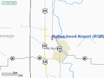
Roben-Hood Airport (IATA: WBR, ICAO: KRQB, FAA LID: RQB) is a public airport located two miles (3 km) northwest of the central business district of Big Rapids, a city in Mecosta County, Michigan, United States. It is owned by the City of Big Rapids.
Although most U.S. airports use the same three-letter location identifier for the FAA and IATA, Roben-Hood Airport is assigned RQB by the FAA and WBR by the IATA.
Facilities and aircraft
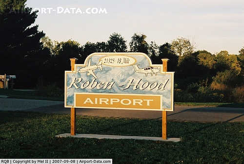
Roben-Hood Airport covers an area of 629 acres (255 ha) which contains two asphalt paved runways: 9/27 measuring 4,300 x 75 ft (1,311 x 23 m) and 14/32 measuring 2,700 x 75 ft (823 x 23 m). For the 12-month period ending December 31, 2005, the airport had 4,040 general aviation aircraft operations. The airport is staffed Monday through Friday from 8:00 a.m. to 5:00 p.m. and is accessible by road from 18 Mile Rd, and is close to Business US-131. Plans are underway for a 700' expansion to runway 9/27.
The above content comes from Wikipedia and is published under free licenses – click here to read more.
|
 |
(Click on the photo to enlarge) |
|
 |
(Click on the photo to enlarge) |
Location & QuickFacts
| FAA Information Effective: | 2008-09-25 |
| Airport Identifier: | RQB |
| Airport Status: | Operational |
| Longitude/Latitude: | 085-30-14.6640W/43-43-21.4780N
-85.504073/43.722633 (Estimated) |
| Elevation: | 990 ft / 301.75 m (Surveyed) |
| Land: | 629 acres |
| From nearest city: | 2 nautical miles NW of Big Rapids, MI |
| Location: | Mecosta County, MI |
| Magnetic Variation: | 05W (2000) |
Owner & Manager
| Ownership: | Publicly owned |
| Owner: | City Of Big Rapids |
| Address: | City Hall
Big Rapids, MI 49307 |
| Phone number: | 231-592-4045 |
| Manager: | Mike Lafferty |
| Address: | 21325 18 Mile Rd
Big Rapids, MI 49307 |
| Phone number: | 231-796-5600 |
Airport Operations and Facilities
| Airport Use: | Open to public |
| Wind indicator: | Yes |
| Segmented Circle: | Yes |
| Control Tower: | No |
| Lighting Schedule: | DUSK-DAWN
ACTVT MIRL RYS 09/27 & 14/32; PAPI RYS 09 & 27; REIL RYS 09 & 27 - CTAF. |
| Beacon Color: | Clear-Green (lighted land airport) |
| Landing fee charge: | No |
| Sectional chart: | Chicago |
| Region: | AGL - Great Lakes |
| Boundary ARTCC: | ZMP - Minneapolis |
| Tie-in FSS: | LAN - Lansing |
| FSS on Airport: | No |
| FSS Toll Free: | 1-800-WX-BRIEF |
| NOTAMs Facility: | RQB (NOTAM-d service avaliable) |
| Federal Agreements: | NGY |
Airport Communications
| CTAF: | 122.800 |
| Unicom: | 122.800 |
Airport Services
| Fuel available: | 100LL
24 HRS SELF-SERVE FUEL. |
Runway Information
Runway 09/27
| Dimension: | 4300 x 75 ft / 1310.6 x 22.9 m |
| Surface: | ASPH, Good Condition |
| Weight Limit: | Single wheel: 20000 lbs. |
| Edge Lights: | Medium |
| |
Runway 09 |
Runway 27 |
| Longitude: | 085-30-59.5280W | 085-30-00.9810W |
| Latitude: | 43-43-28.3370N | 43-43-28.1240N |
| Elevation: | 989.00 ft | 944.00 ft |
| Alignment: | 90 | 127 |
| Traffic Pattern: | Left | Left |
| Markings: | Non-precision instrument, Good Condition | Non-precision instrument, Good Condition |
| Crossing Height: | 25.00 ft | 25.00 ft |
| VASI: | 2-light PAPI on left side | 4-light PAPI on right side |
| Visual Glide Angle: | 3.33° | 3.08° |
| Runway End Identifier: | Yes
REIL OTS INDEFLY. | Yes |
| Obstruction: | 88 ft trees, 2136.0 ft from runway, 22:1 slope to clear | 33 ft tree, 1652.0 ft from runway, 75 ft right of centerline, 44:1 slope to clear |
|
Runway 14/32
| Dimension: | 2700 x 75 ft / 823.0 x 22.9 m |
| Surface: | ASPH, Good Condition |
| Weight Limit: | Single wheel: 20000 lbs. |
| Edge Lights: | Medium |
| |
Runway 14 |
Runway 32 |
| Longitude: | 085-30-00.7970W | 085-29-38.6600W |
| Latitude: | 43-43-21.3500N | 43-43-00.0700N |
| Elevation: | 932.00 ft | 924.00 ft |
| Alignment: | 127 | 127 |
| Traffic Pattern: | Left | Left |
| Markings: | Basic, Good Condition | Basic, Good Condition |
| Runway End Identifier: | | No |
| Centerline Lights: | | No |
| Touchdown Lights: | | No |
| Obstruction: | 80 ft trees, 2440.0 ft from runway, 28:1 slope to clear | 56 ft tree, 1320.0 ft from runway, 140 ft left of centerline, 20:1 slope to clear |
|
Radio Navigation Aids
| ID |
Type |
Name |
Ch |
Freq |
Var |
Dist |
| CAD | NDB | Cadillac | | 269.00 | 04W | 33.4 nm |
| AMN | NDB | Alma | | 329.00 | 05W | 39.5 nm |
| LDM | NDB | Ludington | | 341.00 | 03W | 41.8 nm |
| GDW | NDB | Wiggins | | 209.00 | 04W | 47.0 nm |
| HIC | VOR/DME | White Cloud | 123X | 117.60 | 01W | 12.8 nm |
| MOP | VOR/DME | Mount Pleasant | 043X | 110.60 | 05W | 33.9 nm |
| MBL | VOR/DME | Manistee | 051X | 111.40 | 05W | 46.2 nm |
| MKG | VORTAC | Muskegon | 099X | 115.20 | 01W | 40.6 nm |
Remarks
- DEER ON & INVOF ARPT.
- EXTENSIVE ULTRALIGHT ACTIVITY ON & INVOF ARPT.
Images and information placed above are from
http://www.airport-data.com/airport/RQB/
We thank them for the data!
| General Info
|
| Country |
United States
|
| State |
MICHIGAN
|
| FAA ID |
RQB
|
| Latitude |
43-43-21.478N
|
| Longitude |
085-30-14.664W
|
| Elevation |
990 feet
|
| Near City |
BIG RAPIDS
|
We don't guarantee the information is fresh and accurate. The data may
be wrong or outdated.
For more up-to-date information please refer to other sources.
|
|


