 |
|
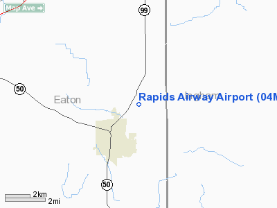
Location & QuickFacts
| FAA Information Effective: | 2008-09-25 |
| Airport Identifier: | 04MI |
| Airport Status: | Operational |
| Longitude/Latitude: | 084-37-41.9270W/42-32-04.1320N
-84.628313/42.534481 (Estimated) |
| Elevation: | 880 ft / 268.22 m (Estimated) |
| Land: | 9 acres |
| From nearest city: | 2 nautical miles NE of Eaton Rapids, MI |
| Location: | Eaton County, MI |
| Magnetic Variation: | 04W (1980) |
Owner & Manager
| Ownership: | Privately owned |
| Owner: | Ronald Goodnoe |
| Address: | 10618 Petrieville Hwy
Eaton Rapids, MI 48827 |
| Phone number: | 517-663-8721 |
| Manager: | Ronald Goodnoe |
| Address: | 10618 Petrieville Hwy
Eaton Rapids, MI 48827 |
| Phone number: | 517-663-8721 |
Airport Operations and Facilities
| Airport Use: | Private |
| Wind indicator: | Yes |
| Segmented Circle: | No |
| Control Tower: | No |
| Sectional chart: | Detroit |
| Region: | AGL - Great Lakes |
| Boundary ARTCC: | ZOB - Cleveland |
| Tie-in FSS: | LAN - Lansing |
| FSS Toll Free: | 1-800-WX-BRIEF |
Runway Information
Runway 18/36
| Dimension: | 2000 x 100 ft / 609.6 x 30.5 m |
| Surface: | TURF, Good Condition |
| |
Runway 18 |
Runway 36 |
| Traffic Pattern: | Left | Left |
| Displaced threshold: | 450.00 ft | 225.00 ft |
| Obstruction: | 50 ft trees, 550.0 ft from runway | 28 ft trees, 560.0 ft from runway |
|
Radio Navigation Aids
| ID |
Type |
Name |
Ch |
Freq |
Var |
Dist |
| BT | NDB | Batol | | 272.00 | 04W | 26.8 nm |
| OZW | NDB | Howell | | 243.00 | 05W | 29.0 nm |
| TCU | NDB | Tecumseh | | 239.00 | 04W | 44.8 nm |
| ADG | NDB | Adrian | | 278.00 | 06W | 46.9 nm |
| AMN | NDB | Alma | | 329.00 | 05W | 47.9 nm |
| JXN | VOR/DME | Jackson | 033X | 109.60 | 05W | 18.2 nm |
| LFD | VOR/DME | Litchfield | 049X | 111.20 | 05W | 29.0 nm |
| GRR | VOR/DME | Grand Rapids | 106Y | 115.95 | 04W | 41.3 nm |
| AZO | VOR/DME | Kalamazoo | 027X | 109.00 | 01W | 44.8 nm |
| LAN | VORTAC | Lansing | 045X | 110.80 | 05W | 11.4 nm |
| BTL | VORTAC | Battle Creek | 031X | 109.40 | 02W | 30.8 nm |
| SVM | VORTAC | Salem | 090X | 114.30 | 03W | 46.5 nm |
| FNT | VORTAC | Flint | 116X | 116.90 | 06W | 46.8 nm |
| PSI | VORTAC | Pontiac | 047X | 111.00 | 03W | 49.5 nm |
Images and information placed above are from
http://www.airport-data.com/airport/04MI/
We thank them for the data!
| General Info
|
| Country |
United States
|
| State |
MICHIGAN
|
| FAA ID |
04MI
|
| Latitude |
42-32-04.132N
|
| Longitude |
084-37-41.927W
|
| Elevation |
880 feet
|
| Near City |
EATON RAPIDS
|
We don't guarantee the information is fresh and accurate. The data may
be wrong or outdated.
For more up-to-date information please refer to other sources.
|
|


