 |
|
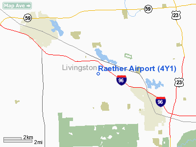
Location & QuickFacts
| FAA Information Effective: | 2008-09-25 |
| Airport Identifier: | 4Y1 |
| Airport Status: | Operational |
| Longitude/Latitude: | 083-51-23.3840W/42-33-55.0520N
-83.856496/42.565292 (Estimated) |
| Elevation: | 982 ft / 299.31 m (Estimated) |
| Land: | 10 acres |
| From nearest city: | 6 nautical miles SE of Howell, MI |
| Location: | Livingston County, MI |
| Magnetic Variation: | 05W (1990) |
Owner & Manager
| Ownership: | Privately owned |
| Owner: | Rodney F. & Judy E. Raether |
| Address: | 2650 Fishbeck Road
Howell, MI 48843 |
| Phone number: | 517-546-4498 |
| Manager: | Rodney F. Raether |
| Address: | 2650 Fishbeck Road
Howell, MI 48843 |
| Phone number: | 517-546-4498 |
Airport Operations and Facilities
| Airport Use: | Open to public |
| Wind indicator: | Yes |
| Segmented Circle: | No |
| Control Tower: | No |
| Landing fee charge: | No |
| Sectional chart: | Chicago |
| Region: | AGL - Great Lakes |
| Boundary ARTCC: | ZOB - Cleveland |
| Tie-in FSS: | LAN - Lansing |
| FSS on Airport: | No |
| FSS Toll Free: | 1-800-WX-BRIEF |
| NOTAMs Facility: | LAN (NOTAM-d service avaliable) |
Airport Communications
Runway Information
Runway 17/35
| Dimension: | 2206 x 60 ft / 672.4 x 18.3 m |
| Surface: | TURF, Fair Condition |
| |
Runway 17 |
Runway 35 |
| Longitude: | 083-51-26.6000W | 083-51-18.7000W |
| Latitude: | 42-34-05.2000N | 42-33-44.2000N |
| Traffic Pattern: | Left | Left |
| Displaced threshold: | 440.00 ft | 553.00 ft |
| Obstruction: | 31 ft trees, 189.0 ft from runway, 125 ft right of centerline, 6:1 slope to clear
APCH RATIO 6:1 TO DSPLCD THLD. BASED ON +43 FT FREES 261 FT FM DSPLCD THLD 90 FT L. | 39 ft trees, 0.0 ft from runway, 84 ft left of centerline
APCH RATIO 7:1 AT DSPLCD THLD BASED ON 50 FT TREES 380 FT FM DSPLCD THLD 55 FT L. |
|
Radio Navigation Aids
| ID |
Type |
Name |
Ch |
Freq |
Var |
Dist |
| OZW | NDB | Howell | | 243.00 | 05W | 7.1 nm |
| TCU | NDB | Tecumseh | | 239.00 | 04W | 31.8 nm |
| G | NDB | Golf | | 398.00 | 05W | 40.8 nm |
| RYS | NDB | Grosse Ile | | 419.00 | 06W | 41.9 nm |
| VQ | NDB | Cargl | | 230.00 | 05W | 41.9 nm |
| ADG | NDB | Adrian | | 278.00 | 06W | 42.9 nm |
| QG | NDB | Windsor | | 353.00 | 06W | 46.4 nm |
| MTC | TACAN | Selfridge | 064X | | 06W | 45.4 nm |
| DXO | VOR/DME | Detroit | 081X | 113.40 | 06W | 30.3 nm |
| JXN | VOR/DME | Jackson | 033X | 109.60 | 05W | 32.4 nm |
| YQG | VOR/DME | Windsor | 085X | 113.80 | 06W | 49.4 nm |
| SVM | VORTAC | Salem | 090X | 114.30 | 03W | 15.0 nm |
| PSI | VORTAC | Pontiac | 047X | 111.00 | 03W | 16.5 nm |
| FNT | VORTAC | Flint | 116X | 116.90 | 06W | 24.6 nm |
| CRL | VORTAC | Carleton | 104X | 115.70 | 03W | 35.8 nm |
| LAN | VORTAC | Lansing | 045X | 110.80 | 05W | 38.3 nm |
| YIP | VOT | Willow Run | | 112.00 | | 24.8 nm |
| DTW | VOT | Detroit Met Wayne | | 109.80 | | 29.8 nm |
| DET | VOT | Detroit City | | 111.60 | | 38.5 nm |
Remarks
- HEAVY EQUIPMENT ADJACENT TO WEST SIDE OF RY 35.
- DEER ON & INVOF RY.
- ULTRALIGHT ACTIVITY ON & INVOF ARPT.
Images and information placed above are from
http://www.airport-data.com/airport/4Y1/
We thank them for the data!
| General Info
|
| Country |
United States
|
| State |
MICHIGAN
|
| FAA ID |
4Y1
|
| Latitude |
42-33-55.052N
|
| Longitude |
083-51-23.384W
|
| Elevation |
982 feet
|
| Near City |
HOWELL
|
We don't guarantee the information is fresh and accurate. The data may
be wrong or outdated.
For more up-to-date information please refer to other sources.
|
|


