 |
|
|
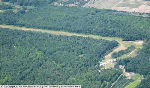 |
(Click on the photo to enlarge) |
|
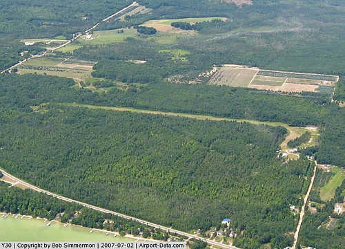 |
(Click on the photo to enlarge) |
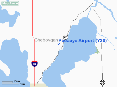
Location & QuickFacts
| FAA Information Effective: | 2008-09-25 |
| Airport Identifier: | Y30 |
| Airport Status: | Operational |
| Longitude/Latitude: | 084-33-25.1340W/45-31-52.0390N
-84.556982/45.531122 (Estimated) |
| Elevation: | 690 ft / 210.31 m (Surveyed) |
| Land: | 40 acres |
| From nearest city: | 3 nautical miles NE of Topinabee, MI |
| Location: | Cheboygan County, MI |
| Magnetic Variation: | 06W (1985) |
Owner & Manager
| Ownership: | Privately owned |
| Owner: | Pbeaaye Inc. |
| Address: | 3299 Tryban Rd
Cheboygan, MI 49721 |
| Phone number: | 231-627-5791 |
| Manager: | George R. Thomson |
| Address: | 3299 Tryban Rd
Cheboygan, MI 49721 |
| Phone number: | 231-627-5791
231-238-9553. |
Airport Operations and Facilities
| Airport Use: | Open to public |
| Wind indicator: | Yes |
| Segmented Circle: | No |
| Control Tower: | No |
| Landing fee charge: | No |
| Sectional chart: | Lake Huron |
| Region: | AGL - Great Lakes |
| Boundary ARTCC: | ZMP - Minneapolis |
| Tie-in FSS: | LAN - Lansing |
| FSS on Airport: | No |
| FSS Toll Free: | 1-800-WX-BRIEF |
| NOTAMs Facility: | LAN (NOTAM-d service avaliable) |
Airport Communications
Airport Services
Runway Information
Runway 01/19
| Dimension: | 2470 x 90 ft / 752.9 x 27.4 m |
| Surface: | TURF, Poor Condition
RWY SFC ROLLING TERRAIN, ROUGH. |
| |
Runway 01 |
Runway 19 |
| Traffic Pattern: | Left | Left |
| Displaced threshold: | 450.00 ft | 800.00 ft |
| Obstruction: | 50 ft trees, 100 ft right of centerline
APCH RATIO 0:1 AT DSPLCD THLD. 30 FT TREES 65 FT L/R, 25:1 BASED ON STRAIGHT OUT OVR +50 FT TREES 1250 FT DSTC. | 60 ft trees, 0.0 ft from runway, 60 ft right of centerline
RWY 19 APCH RATIO 0:1 AT DSPLCD THLD. 30 FT TREES 90 FT L/R, 20:1 BASED ON STRAIGHT OUT OVR +85 FT TREES, 1700 FT DSTC. |
|
Radio Navigation Aids
| ID |
Type |
Name |
Ch |
Freq |
Var |
Dist |
| BFA | NDB | Boyne Falls | | 263.00 | 06W | 26.8 nm |
| PZQ | NDB | Rogers City | | 215.00 | 07W | 32.0 nm |
| CVX | NDB | Charlevoix | | 392.00 | 05W | 33.1 nm |
| SJX | NDB | St James | | 382.00 | 05W | 43.2 nm |
| DRM | NDB | Drummond Island | | 218.00 | 07W | 44.6 nm |
| CXK | NDB | Clam Lake | | 251.00 | 05W | 47.7 nm |
| CI | NDB | Koloe | | 400.00 | 06W | 48.2 nm |
| GYG | NDB | Grayling | | 359.00 | 06W | 48.3 nm |
| GLR | VOR/DME | Gaylord | 029X | 109.20 | 06W | 31.8 nm |
| PLN | VORTAC | Pellston | 055X | 111.80 | 06W | 7.5 nm |
Remarks
- TREES ALL QUADRANTS.
- DEER & BIRDS INVOF ARPT.
- WINTER OPNS SKIS ONLY
- +60 FT WINDSOCK LCTD AT N END.
- PRVDD OBSTNS IN APCH SFC ARE RMVD/LWRD TP PRVD 20:1 CLRNC FM RWY END OR THRS LCTD/MKD TO PRVD 10:1 CLRNC OVR OBSTNS.
Images and information placed above are from
http://www.airport-data.com/airport/Y30/
We thank them for the data!
| General Info
|
| Country |
United States
|
| State |
MICHIGAN
|
| FAA ID |
Y30
|
| Latitude |
45-31-52.039N
|
| Longitude |
084-33-25.134W
|
| Elevation |
690 feet
|
| Near City |
TOPINABEE
|
We don't guarantee the information is fresh and accurate. The data may
be wrong or outdated.
For more up-to-date information please refer to other sources.
|
|


