 |
|
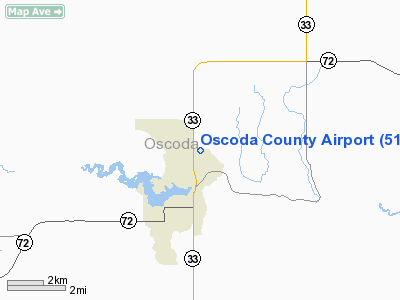
Location & QuickFacts
| FAA Information Effective: | 2008-09-25 |
| Airport Identifier: | 51M |
| Airport Status: | Operational |
| Longitude/Latitude: | 084-07-30.0200W/44-40-50.0480N
-84.125006/44.680569 (Estimated) |
| Elevation: | 1050 ft / 320.04 m (Estimated) |
| Land: | 80 acres |
| From nearest city: | 2 nautical miles N of Mio, MI |
| Location: | Oscoda County, MI |
| Magnetic Variation: | 05W (1985) |
Owner & Manager
| Ownership: | Publicly owned |
| Owner: | Oscoda County |
| Address: | 311 Morenci
Mio, MI 48619 |
| Phone number: | 989-826-1130 |
| Manager: | David E. Kauffman |
| Address: | 191 S. Mt Tom Rd
Mio, MI 48647 |
| Phone number: | 989-848-2446 |
Airport Operations and Facilities
| Airport Use: | Open to public |
| Wind indicator: | Yes |
| Segmented Circle: | No |
| Control Tower: | No |
| Lighting Schedule: | RDO-CTL
ACTVT LIRL RY 09/27 - CTAF. |
| Landing fee charge: | No |
| Sectional chart: | Lake Huron |
| Region: | AGL - Great Lakes |
| Boundary ARTCC: | ZMP - Minneapolis |
| Tie-in FSS: | LAN - Lansing |
| FSS on Airport: | No |
| FSS Toll Free: | 1-800-WX-BRIEF |
| NOTAMs Facility: | LAN (NOTAM-d service avaliable) |
Airport Communications
Airport Services
Runway Information
Runway 09/27
| Dimension: | 2800 x 90 ft / 853.4 x 27.4 m |
| Surface: | DIRT, Poor Condition
LARGE AREAS OF DIRT ON RWY.
ROUGH WITH LARGE AREAS OF SOFT SAND ON RY. |
| Edge Lights: | Low |
| |
Runway 09 |
Runway 27 |
| Traffic Pattern: | Left | Left |
| Displaced threshold: | 978.00 ft | 784.00 ft |
| Obstruction: | 60 ft trees, 240.0 ft from runway, 135 ft right of centerline, 4:1 slope to clear
APCH RATIO 20:1 AT DSPLCD THLD. | 56 ft trees, 1008.0 ft from runway, 18:1 slope to clear
APCH RATIO 25:1 AT DSPLCD THLD OVR + 70 FT TREE, 1750 FT DSTC, 160 FT R. |
|
Radio Navigation Aids
| ID |
Type |
Name |
Ch |
Freq |
Var |
Dist |
| BHW | NDB | Hardwood | | 236.00 | 06W | 26.0 nm |
| GYG | NDB | Grayling | | 359.00 | 06W | 30.3 nm |
| BFA | NDB | Boyne Falls | | 263.00 | 06W | 44.8 nm |
| GDW | NDB | Wiggins | | 209.00 | 04W | 45.3 nm |
| PZQ | NDB | Rogers City | | 215.00 | 07W | 45.4 nm |
| CXK | NDB | Clam Lake | | 251.00 | 05W | 49.3 nm |
| CGG | VOR | Grayling | | 109.80 | 06W | 25.8 nm |
| BXZ | VOR/DME | West Branch | 079X | 113.20 | 06W | 26.4 nm |
| HTL | VOR/DME | Houghton Lake | 053X | 111.60 | 05W | 30.2 nm |
| GLR | VOR/DME | Gaylord | 029X | 109.20 | 06W | 31.7 nm |
| ASP | VOR/DME | Au Sable | 108X | 116.10 | 07W | 34.2 nm |
| APN | VORTAC | Alpena | 025X | 108.80 | 07W | 34.2 nm |
Remarks
Images and information placed above are from
http://www.airport-data.com/airport/51M/
We thank them for the data!
| General Info
|
| Country |
United States
|
| State |
MICHIGAN
|
| FAA ID |
51M
|
| Latitude |
44-40-50.048N
|
| Longitude |
084-07-30.020W
|
| Elevation |
1050 feet
|
| Near City |
MIO
|
We don't guarantee the information is fresh and accurate. The data may
be wrong or outdated.
For more up-to-date information please refer to other sources.
|
|


